
Context
In October 2026, a 17-member Indian Coast Guard team scaled Mount Mukut (7,045 m) under Himalayan Mountaineering Institute (HMI) Darjeeling’s guidance, completing a key training milestone for its planned 2027 Mount Everest expedition.
About Mount Mukut
- Location: Garhwal Himalayas, Uttarakhand, near Mount Kamet and northeast of Badrinath.
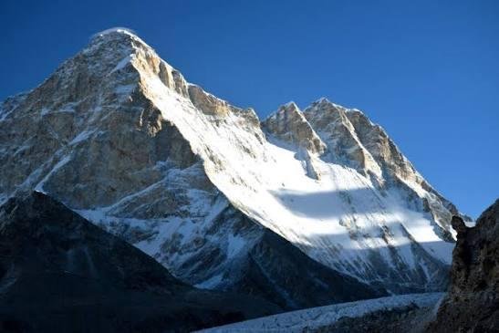
- Name: Mukut means “crown” in Hindi, referring to the peak’s distinctive shape.
- Terrain: Its upper slopes consist of exposed rocks, permanent snow, glacier ice and ridges exposed to strong winds.
- Geographical Setting: Lies in a high-altitude Himalayan region that transitions from monsoon-influenced valleys to the colder, drier landscape towards the Tibetan Plateau.
- Mount Mukut was first climbed in 1951 by a New Zealand expedition team that included Edmund Hillary and George Lowe.
Key Facts about the Garhwal Himalayas
- Location: Western part of the Central Himalayas, primarily in Uttarakhand.
- Extent: Commonly described as extending from the Tons River in the west towards the Kali River in the east.
- Boundaries: The Greater Himalayan region borders Tibet (China) to the north, while the Shivalik Hills mark its southern transition.
- Major Rivers: Bhagirathi, Alaknanda, Mandakini and Yamuna.
- Vegetation: Pine, oak, deodar, fir and rhododendron forests occur at different elevations.
Frequently Asked Questions (FAQs)
Q1. Where is Mount Mukut located, and what is its height?
Mount Mukut is located in the Garhwal Himalayas of Uttarakhand, near Mount Kamet and northeast of Badrinath. It is approximately 7,045 metres high.
Q2. Who first climbed Mount Mukut?
Mount Mukut was first climbed in 1951 by a New Zealand expedition team that included Edmund Hillary and George Lowe.
Q3. What are the major geographical features of Mount Mukut?
Its upper slopes feature exposed rocks, permanent snow, glacier ice and wind-exposed ridges. The region transitions from monsoon-influenced valleys to the colder, drier landscape towards the Tibetan Plateau.
Q4. Which major rivers flow through the Garhwal Himalayas?
The major rivers include the Bhagirathi, Alaknanda, Mandakini and Yamuna. The region also supports forests of pine, oak, deodar, fir and rhododendron at different elevations.