Context
A private jet was recently landed for the first time under the supervision of the Directorate General of Civil Aviation (DGCA) using the GPS Aided GEO Augmented Navigation (GAGAN) system, highlighting India’s indigenous satellite-based navigation capability for civil aviation.
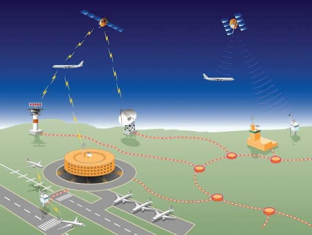
About GPS Aided GEO Augmented Navigation (GAGAN)
- GPS Aided GEO Augmented Navigation (GAGAN) is India’s Satellite-Based Augmentation System (SBAS), jointly developed by the Airports Authority of India (AAI) and the Indian Space Research Organisation (ISRO).
- It enhances the accuracy, integrity, and reliability of GPS signals, enabling safe and precise navigation for civil aviation.
- Its primary objectives are to provide high-precision satellite navigation and improve air traffic management over Indian airspace.
- GAGAN is interoperable with international SBAS networks, enabling seamless navigation across regional boundaries.
- The system integrates ground and space segments to detect GPS signal errors, generate corrections, and transmit accurate navigation information to aircraft.
Ground Segment
- Indian Reference Stations (INRES): A network of 15 reference stations across India continuously monitors GPS signals and detects errors caused by ionospheric disturbances, satellite orbit variations, and clock inaccuracies.
- Indian Master Control Centre (INMCC): Processes data received from the reference stations and generates correction messages.
- Indian Land Uplink Station (INLUS): Transmits the correction messages to geostationary satellites for broadcasting to aircraft.
Space Segment
- The space segment comprises GSAT-8 (2011), GSAT-10 (2012), and GSAT-15 (2015), each carrying dedicated GAGAN payloads.
- These geostationary satellites broadcast the correction messages to GPS receivers on aircraft, enabling accurate and reliable navigation.
Importance
- Enhances the accuracy and safety of aircraft navigation and precision landing.
- Improves air traffic management and the efficient utilisation of Indian airspace.
- Minimises navigation errors caused by atmospheric disturbances and satellite inaccuracies.
- Ensures compatibility with global Satellite-Based Augmentation Systems (SBAS) for seamless cross-border navigation.
- Strengthens India’s indigenous satellite-based navigation capability and reduces dependence on foreign augmentation systems.
Conclusion
GAGAN is a significant achievement in India’s aviation and space sectors. By integrating satellite technology with ground-based correction systems, it provides accurate and reliable navigation services, enhances aviation safety, and strengthens India’s self-reliance in satellite-based air navigation.