Context
Large-scale protests in Albania against a proposed luxury tourism project along its Adriatic coast have brought the country into focus, highlighting its geographical location and strategic significance in the Balkan region.
About Albania
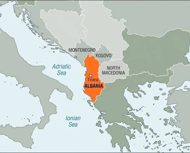
- Albania is a country in Southeastern Europe on the Balkan Peninsula, with Tirana as its capital.
- It shares land borders with Montenegro (northwest), Kosovo (northeast), North Macedonia (east), and Greece (south and southeast).
- It is bounded by the Adriatic Sea to the west and the Ionian Sea to the southwest. The Strait of Otranto separates Albania from Italy and connects these two seas.
- The country is predominantly mountainous, with the Albanian Alps, Korab Mountains, and Pindus Mountains as its major mountain ranges. Mount Korab is the highest peak.
- The western coastal region experiences a Mediterranean climate, while the interior and eastern regions have a continental climate.
- Major rivers include the Drin and Vjosa. Important lakes include Lake Shkodër (shared with Montenegro) and Lakes Ohrid and Prespa (shared with North Macedonia).
- Albania possesses reserves of petroleum, natural gas, coal, and metallic minerals, particularly chromite.
Its strategic location along the Adriatic–Ionian maritime corridor enhances its geopolitical, economic, and maritime significance in the Balkan region.