
Context
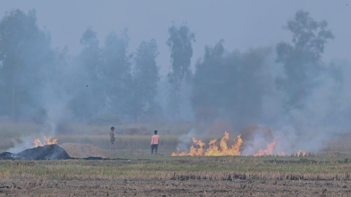
- Stubble burning remains a recurring seasonal issue in Punjab, Haryana and parts of western Uttar Pradesh, where the rice–wheat cropping cycle leaves farmers with a narrow window to prepare fields for wheat.
- Government data show a sharp decline in satellite-detected farm fires. However, analysis of 2025 burning patterns suggests that the decline in detected fires may be greater than the actual reduction in the area affected by burning.
- A key concern is the timing of fires. A large share of fires occurred during the late afternoon and evening, when some polar-orbiting satellites have fewer observation opportunities.
- This highlights the need to combine satellite monitoring, burnt-area assessment and ground verification rather than relying only on the number of detected fire incidents.
Why Farmers Burn Crop Residue
- Short sowing window: Paddy harvesting and wheat sowing are separated by a limited period. Burning provides a quick method of clearing fields.
- High removal cost: Collecting, transporting and processing large quantities of paddy residue can be expensive for small and marginal farmers.
- Combine harvesting: Mechanical harvesting leaves substantial quantities of straw in the field, making manual removal difficult.
- Limited economic returns: Where suitable markets or local uses for residue are unavailable, farmers may find burning the least-cost option.
Environmental and Health Impacts
- Burning releases PM2.5, PM10, carbon monoxide and nitrogen oxides, contributing to poor air quality.
- Fine particulate matter can aggravate respiratory and cardiovascular problems, particularly among vulnerable populations.
- Repeated burning reduces the availability of organic matter for the soil and can affect beneficial soil organisms and nutrients.
- It also releases greenhouse gases and wastes biomass that could otherwise be used for energy, compost, fodder or industrial applications.
Impact on Delhi-NCR Air Quality
- Crop-residue burning is an important seasonal contributor to pollution episodes in Delhi-NCR, but it is not the sole source. Vehicles, industries, construction, road dust and waste burning also contribute significantly.
- After the monsoon, lower wind speeds, temperature inversion and a shallow atmospheric boundary layer can restrict dispersion of pollutants.
- Regional transport of smoke can therefore worsen pollution when agricultural burning coincides with unfavourable winter meteorological conditions.
Satellite Monitoring and Its Limitations
- India has developed a multi-agency monitoring system involving ISRO, State Remote Sensing Centres, IARI and CAQM.
- Satellite systems such as MODIS and VIIRS identify active fire locations during satellite overpasses.
- The monitoring system also uses burnt-area assessment, which provides a different measure from the number of individual fire detections.
- The principal limitation is temporal coverage. A fire that starts and ends between satellite overpasses may not be detected.
- Analysis of 2025 data found that many large fires occurred during the late afternoon and evening, reducing the effectiveness of some polar-satellite observations.
- An iFOREST analysis estimated that around 20,000 sq km in Punjab and 8,800 sq km in Haryana was affected by burning in 2025. This indicates that the actual area burnt may be substantially different from what simple fire-count data suggest.
Key distinction: A reduction in detected fire incidents does not automatically mean an equivalent reduction in the total area burnt.
Role of CAQM
The Commission for Air Quality Management (CAQM) is a statutory body established under the CAQM Act, 2021 to coordinate air-quality management across Delhi-NCR and adjoining areas.
Its role in crop-residue management includes:
- Coordinating with Punjab, Haryana, Uttar Pradesh, Rajasthan and Delhi.
- Supporting satellite-based monitoring and field-level enforcement.
- Promoting in-situ and ex-situ crop-residue management.
- Using environmental compensation and enforcement measures against violations.
- Improving inter-state coordination because air pollution does not remain confined to administrative boundaries.
Environmental Compensation
CAQM has prescribed differentiated compensation for crop-burning incidents:
- Less than 2 acres: ₹5,000
- 2 to less than 5 acres: ₹10,000
- More than 5 acres: ₹30,000
Way Forward
- Improve monitoring: Combine polar and geostationary satellite data to obtain more frequent observations of agricultural fires.
- Strengthen ground verification: Use field teams, local officials and targeted inspections to validate satellite observations.
- Measure outcomes, not just fires: Track burnt area, residue management and air-quality outcomes alongside fire counts.
- Create economic alternatives: Expand markets for biomass, bioenergy, compressed biogas, compost and other residue-based products.
- Improve access to machinery: Strengthen Custom Hiring Centres so small farmers can access residue-management equipment at affordable rates.
- Promote crop diversification: Reduce excessive dependence on the rice–wheat cycle in areas facing severe groundwater and residue-management pressures.
- Balance incentives and enforcement: Combine financial support and technological assistance with credible penalties for deliberate burning.
Conclusion
The stubble-burning challenge is not merely an issue of farmer compliance; it is also a problem of agricultural incentives, technology, measurement and inter-state governance. A reliable policy framework must measure the actual extent of burning rather than depending solely on satellite fire counts. Better monitoring, economically viable residue management and crop diversification can make the transition towards sustainable agriculture more effective.
UPSC-Oriented FAQs
- Why is stubble burning common in north-western India?
Answer: The rice–wheat cycle leaves farmers with a short interval between paddy harvesting and wheat sowing. Burning provides a quick and inexpensive method of clearing crop residue.
- Why can satellite fire counts underestimate crop burning?
Answer: Polar-orbiting satellites observe a location only during specific overpasses. Fires occurring between these observation windows, particularly for short durations, may remain undetected.
- What is the difference between active-fire detection and burnt-area assessment?
Answer: Active-fire detection identifies locations where fire is detected at a particular time. Burnt-area assessment estimates the land surface affected by burning and can provide a broader measure of its extent.
- What is the role of CAQM in controlling stubble burning?
Answer: CAQM coordinates air-pollution control measures across Delhi-NCR and adjoining areas, including satellite monitoring, enforcement, crop-residue management and inter-state coordination.
- Is stubble burning the only cause of Delhi’s winter pollution?
Answer: No. It is an important seasonal contributor, but vehicles, industries, construction, road dust, waste burning and adverse meteorological conditions also play major roles.
- What measures can provide a long-term solution to stubble burning?
Answer: Long-term solutions include crop diversification, affordable residue-management machinery, biomass-based economic uses, financial incentives, stronger field verification and effective enforcement.