The Chota Nagpur Plateau is a formidable geological and cultural bastion in eastern India, often referred to as the “Mineral Heart of India.” Spanning an area of approximately 65,000 square kilometres, this ancient landform acts as the primary engine for India’s industrial sector. Primarily encompassing the state of Jharkhand, the plateau extends its rocky fingers into Chhattisgarh, Odisha, West Bengal, and Bihar, creating a trans-state economic corridor defined by coal mines, steel plants, and a rich tribal tapestry.
Geological Formation and Topography
The Chota Nagpur Plateau is composed mainly of Precambrian rocks, specifically granite and gneiss, it dates back over 540 million years.
The Structure
The plateau is unique due to its stepped topography, shaped by tectonic uplift during the Cenozoic era and millions of years of erosion. It is categorized into three distinct elevational steps:
- The Highest Step (Western): Elevation ranges from 910 to 1,070 meters.
- The Intermediate Step: Average elevation sits around 610 meters.
- The Lowest Step (Eastern): Descends to approximately 300 meters.
Key Topographical Features
- Highest Peak: Parasnath Hill (1,164 meters), located in the Giridih district, is not only a geographical marvel but also a major Jain pilgrimage site.
- Sub-Plateaus: The region collectively refers to the Ranchi Plateau, Hazaribagh Plateau, and Koderma Plateau.
- Climate: It experiences a tropical climate with a significant monsoon influence, receiving an average of 1,400 mm of rainfall annually.
Mineral Wealth:
The Chota Nagpur Plateau is the backbone of India’s metallurgical and energy sectors. Its unique stratigraphy, including the Dharwar Series metamorphic rocks, houses an unparalleled variety of minerals.
- Coal: The Damodar Valley is home to the Jharia and Bokaro coalfields, producing high-quality bituminous coal essential for thermal power and steel making.
- Iron Ore: Abundant deposits of Hematite and Magnetite have facilitated the rise of Jamshedpur (Tata Steel) and Bokaro Steel City.
- Mica: Hazaribagh and Koderma are globally recognized as major hubs for mica mining.
- Bauxite: Large-scale deposits support the nation’s aluminium production.
- Other Resources: The plateau also contains significant quantities of chromite, copper, asbestos, and kyanite.
Hydrological Network:
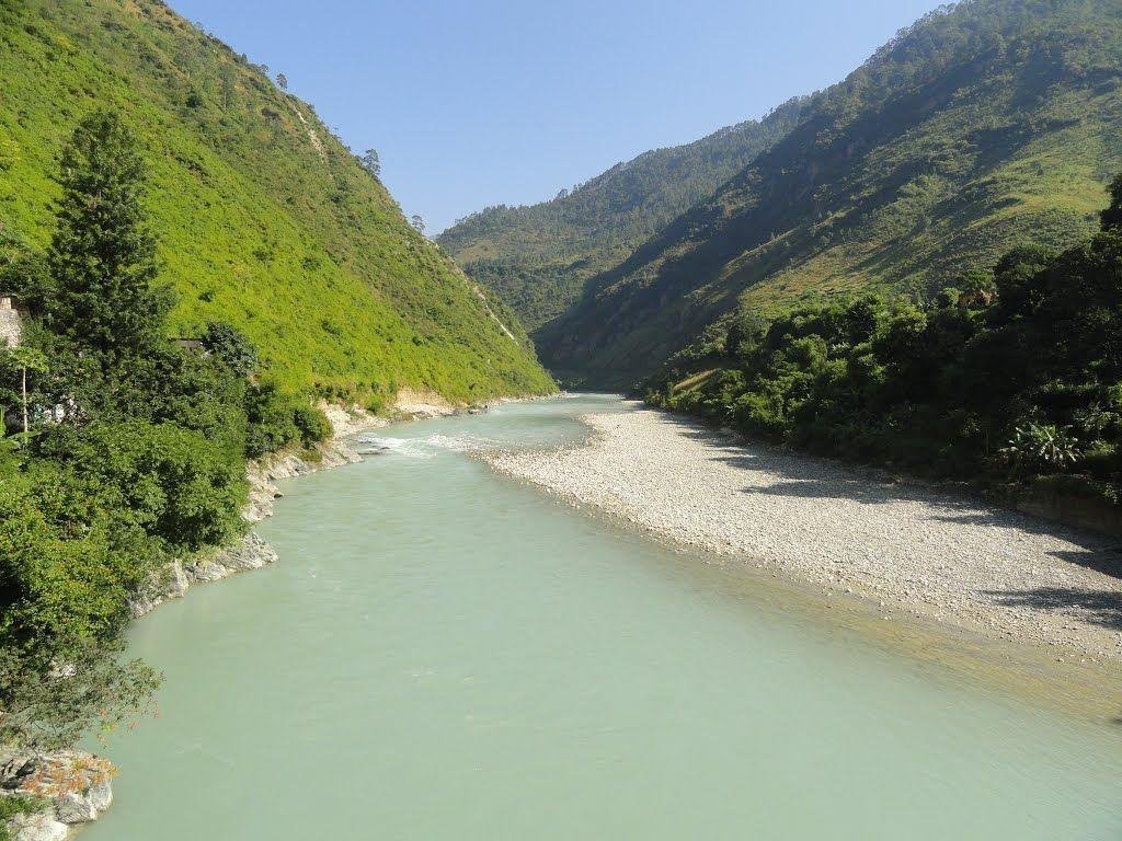
The plateau acts as a drainage divide between the Ganges and Mahanadi systems. The rivers originating here are crucial for both industrial cooling and rural irrigation.
| River | Significance |
| Damodar | Known as the “Sorrow of Bengal” for historical floods; now harnessed for coal-based industries. |
| Subarnarekha | It rises near Ranchi; the only river in the region to flow directly into the Bay of Bengal. |
| Brahmani | Formed by the confluence of the South Koel and Sankh rivers. |
| Koel (North & South) | Vital for agriculture in Palamu and surrounding districts. |
| Barakar | A major tributary of the Damodar, supporting various dam projects. |
Tribal Communities and Cultural Heritage
The human landscape of the plateau is as diverse as its minerals. It is the ancestral home to several major tribal groups (Adivasis), each with distinct languages and socio-political structures.
- Santhal: One of India’s largest tribal groups, known for the Santhali language and vibrant dance traditions.
- Munda: Celebrated for their historical resistance under Birsa Munda; they revere the Karam tree during fertility festivals.
- Oraon: Primarily agriculturists who speak the Kurukh (Oraon) language.
- Ho & Gond: Known for their unique native languages and forest-dependent lifestyles, practicing shifting cultivation in the Singhbhum and central regions.
Economic and Strategic Significance
- Industrial Hubs: The plateau has birthed “Steel Cities” like Jamshedpur and Bokaro, which are central to India’s GDP.
- Forest Economy: Tropical deciduous forests provide valuable resources like Lac and Tussah silk (Kosa silk), supporting local livelihoods.
- Biodiversity: The rugged terrain provides a sanctuary for leopards, elephants, and diverse avian species.
- Connectivity: Extensive rail networks link the mineral-rich interior to the ports of Kolkata and the markets of Patna.
FAQs: Chota Nagpur Plateau
Q1 Which state contains the largest portion of the Chota Nagpur Plateau?
Jharkhand holds the majority of the plateau’s land area and its primary mineral wealth.
Q2 What is the highest point of the Chota Nagpur Plateau?
The highest point is Parasnath Hill, standing at 1,164 meters.
Q3 Which river is popularly known as the “Sorrow of Bengal” and originates in this plateau?
The Damodar River is traditionally known as the “Sorrow of Bengal” due to its history of devastating floods.
Q4 What are the primary types of rocks found in the plateau?
The plateau is predominantly composed of ancient Precambrian rocks, including granite and gneiss.
Q5 Which minerals are most abundant in the Damodar Valley?
The Damodar Valley is world-famous for its massive coal deposits, specifically bituminous coal.
Q6 Name the major tribal groups inhabiting the Chota Nagpur region.
The major tribes include the Santhal, Munda, Oraon, Ho, and Gond.
Q7 Why is Jamshedpur significant in the context of this plateau?
Jamshedpur is home to Tata Steel, India’s first integrated private steel plant, established because of the proximity to iron ore and coal in the plateau.
Q8 Does the Chota Nagpur Plateau receive high rainfall?
Yes, it receives an average annual rainfall of 1,400 millimetres, mostly during the monsoon months.
Q9 Which sub-plateaus make up the Chota Nagpur region?
It is composed of the Ranchi, Hazaribagh, and Koderma plateaus.
Q10 What is the historical significance of the plateau in India’s freedom struggle?
The plateau was the site of significant anti-colonial resistance, most notably the Ulgulan (Great Tumult) led by the tribal leader Birsa Munda.