The Aravalli Range is not merely a geographical feature — it is a living archive of Earth’s ancient tectonic history, a critical ecological shield, and a contested zone of resource extraction and conservation. From its role as a natural barrier against desert expansion to its recent appearance in a landmark Supreme Court ruling in November 2025, the Aravalli Hills remain one of the most significant and multidimensional mountain systems in India. This comprehensive guide covers everything from geology and drainage to minerals and ecology — structured for UPSC aspirants and geography enthusiasts alike.
Why Is the Aravalli Range in the News?
In November 2025, the Supreme Court of India delivered a significant ruling that brought the Aravalli Hills back into national focus. The Court formally defined what constitutes an “Aravalli Hill,” a move that has far-reaching implications for mining regulation, land use, and ecological protection in the region.
The central concern raised was that the new legal definition — limiting Aravalli Hills to elevations 100 metres or higher above the local ground level — could potentially weaken existing legal protections for lower-lying but ecologically critical areas that had previously been treated as part of the hill system.
This ruling has sparked debate among environmentalists, state governments, mining companies, and conservationists, making it a high-relevance topic for UPSC General Studies and Current Affairs preparation.
Supreme Court Definition and Guidelines for the Aravalli Range
How the Supreme Court Defined Aravalli Hills
- Aravalli Hills are defined as any landform rising 100 metres or more above the surrounding local terrain.
- Local relief is measured using the lowest contour line encircling the hill — providing a standardised, objective basis for classification.
- Protection under this definition applies to the entire hill system, including supporting slopes and associated landforms, regardless of their individual height.
How the Supreme Court Defined Aravalli Ranges
- Aravalli Ranges are defined as clusters of two or more hills located within 500 metres of each other.
- The entire intervening area between such hills — including slopes, smaller hillocks, and transitional landforms — is considered an integral part of the range and receives corresponding legal protection.
Supreme Court Directions on Mining
- A temporary ban has been imposed on the issuance of new mining leases in areas falling within the Aravalli definition.
- Existing legal mining operations are permitted to continue but must operate under strict regulatory oversight.
- The ban on new leases will remain in place until a Management Plan for Sustainable Mining (MPSM) is prepared by the Indian Council of Forestry Research and Education (ICFRE).
Requirements for the Management Plan (MPSM)
- Identify no-mining zones and strictly regulated mining areas based on ecological sensitivity.
- Map sensitive habitats and wildlife corridors to prevent ecological fragmentation.
- Assess cumulative ecological impacts and the carrying capacity of the landscape to absorb continued mining activity.
- Prescribe specific restoration and rehabilitation measures for areas already affected by past mining operations.
Key Observations Made by the Supreme Court
- The Court recognised that blanket bans on all mining activity can paradoxically fuel illegal and unregulated mining, making enforcement harder rather than easier.
- The Court therefore adopted a calibrated, three-pronged approach:
- A temporary pause on the issuance of new mining leases
- Regulated continuation of existing legal mining under supervision
- Permanent protection of ecologically sensitive areas that fall within the Aravalli system
About the Aravalli Range: An Overview
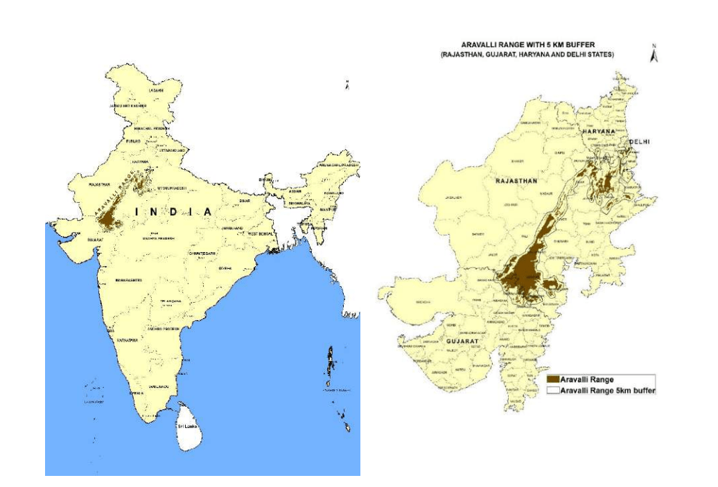
The Aravalli Range, also referred to as the Aravali Hills, is among the oldest surviving mountain systems on Earth. It forms one of the most prominent physiographic divisions of north-western India and constitutes a major natural boundary within the Indian subcontinent.
Although the range has been heavily eroded over geological time and no longer resembles the towering fold mountains it once was, it continues to exert a powerful influence on climate, drainage, mineral resources, ecology, and human settlement patterns across Rajasthan, Haryana, Gujarat, and adjoining territories.
Location and Extent of the Aravalli Range
- The Aravalli Range is located in north-western India and is one of the most prominent physiographic features of the region.
- The range extends in a south-west to north-east orientation, which distinguishes it from most other Indian mountain ranges that run roughly parallel to the coasts.
- Its northernmost extension begins near Delhi, where the hills manifest as discontinuous, low-lying ridges — barely recognisable as part of an ancient mountain system.
- From Delhi, the range passes through southern Haryana, influencing the drainage patterns and ecological character of the region.
- It then traverses through central and southern Rajasthan, where it reaches its greatest prominence in terms of both height and width.
- The range finally terminates near Ahmedabad in Gujarat, gradually merging into the surrounding plains with no dramatic conclusion.
Physical Characteristics of the Aravalli Range
- The range is composed of discontinuous ridges, hills, and residual mountains, forming a rugged, irregular terrain rather than a smooth, continuous chain.
- The width of the range varies considerably — between 6 to 60 miles — reflecting the uneven nature of erosion and geological exposure.
- Average elevations range from 1,000 to 3,000 feet, though the terrain can vary significantly at the local level.
- The highest peak in the range is Guru Shikhar, located in Mount Abu, Rajasthan, at an elevation of 5,650 feet (1,722 metres) — also the highest point in Rajasthan.
- The total length of the range is approximately 670 kilometres, running from Delhi in the north-east to Ahmedabad in the south-west.
- The range divides Rajasthan into two climatically and ecologically distinct regions:
- The north-western arid zone, dominated by sand dunes, sparse vegetation, and semi-desert conditions
- The south-eastern fertile zone, characterised by better drainage, more reliable rainfall, and denser human population
- Terrain features include steep slopes, sharp ridges, hillocks, and low plateaus, with localised variations in relief creating diverse microclimates — supporting different vegetation types and land use patterns.
- The range acts as both a climatic and hydrological barrier, influencing rainfall distribution across Rajasthan and determining the course of several river systems.
Geological Formation and Evolution of the Aravalli Range
- The Aravalli Range was formed during the Proterozoic Era — making it one of the oldest mountain systems on Earth, predating even the Himalayas by hundreds of millions of years.
- It forms a key part of the Aravalli–Delhi Orogenic Belt and is an integral component of the Indian Shield, providing direct evidence of ancient cratonic collisions that shaped the Indian subcontinent.
- The range initially consisted of very high fold mountains — comparable to modern ranges like the Alps or Himalayas in their original height — but has since been extensively worn down by millions of years of weathering, denudation, and erosion.
- The exposed rock formations display gneiss, schist, quartzite, and marble, reflecting a complex geological history involving heat, pressure, and metamorphic transformation.
- The range provides crucial scientific evidence of ancient tectonic activity, plate movements, and early Earth processes — making it a site of significant geological research.
- The landscape also contains paleochannels and river valleys, which are ancient, now-dry or seasonally active river beds that indicate the presence of formerly extensive drainage systems across the region.
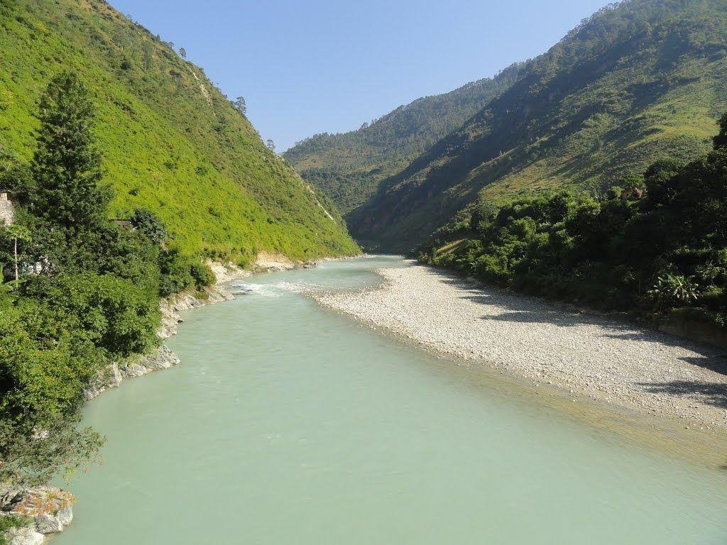
Drainage System of the Aravalli Range
The Aravalli Range functions as a major watershed of north-western India, with rivers flowing in opposite directions from its western and eastern slopes — creating two distinct drainage systems.
Western-Slope Drainage
- Rivers originating on the western slopes of the Aravalli flow into inland basins or ultimately towards the Arabian Sea.
- Key rivers include the Luni, Sakhi, and Sabarmati, all of which flow through arid and semi-arid regions.
- These rivers often end in marshes and salt flats such as the Rann of Kutch, rather than reaching the open sea directly.
- Historically significant: the river valleys and adjacent terraces along western-slope rivers contain Indus Valley Civilisation sites, indicating that these drainage corridors were important zones of early human settlement.
Eastern-Slope Drainage
- Rivers from the eastern slopes flow north-eastward into the Yamuna river system, ultimately contributing to the Ganga basin.
- Key rivers include the Chambal, Banas, and Berach, all of which are significant tributaries of the Yamuna.
- The Ahar River, a tributary of the Banas, is responsible for forming lakes such as Lake Pichola in Udaipur, a major heritage water body.
The Sahibi River and Its Tributaries
- The Sahibi River and its tributaries — including the Dohan, Sota, and Krishnavati — flow north-westward into the Yamuna.
- These rivers and their paleochannels contain key wetlands such as Bhindawas and Sultanpur, both of which are ecologically important bird habitats and protected areas.
Mineral Resources of the Aravalli Range
- The Aravalli Range is recognised as one of India’s oldest and most productive mineral belts, with evidence of continuous mining activity since ancient times.
- The range is particularly rich in the following economically significant minerals:
- Copper — mined historically and remains economically active in parts of Rajasthan
- Zinc and Lead — the Zawar mines near Udaipur are among the world’s oldest known zinc-smelting sites
- Marble and building stones — extensively quarried and used in construction, monuments, and handicrafts; Makrana marble, famously used in the Taj Mahal, comes from this region
- Historical mining in the Aravallis contributed directly to early metallurgy, regional trade, and the establishment of settlements along mineral-rich corridors.
- Current regulations — particularly in light of the Supreme Court’s 2025 directions — place significant emphasis on sustainable mining practices, especially in ecologically sensitive zones.
- Mineral-rich zones within the Aravalli continue to influence regional industrial growth, employment generation, and economic planning in Rajasthan and adjacent states.
Ecological and Historical Significance of the Aravalli Range
Ecological Role
- The Aravalli Range serves as a natural barrier preventing the eastward spread of the Thar Desert, playing a crucial role in mitigating desertification across northern India, a function that makes its protection environmentally critical.
- The range supports critical wetlands, lakes, and wildlife habitats, including several bird sanctuaries and protected forest zones.
- It plays a central role in river origin, groundwater recharge, and soil fertility — functions that are directly tied to agricultural productivity and the sustainability of settlements across a vast region.
- The Aravalli ecosystem informs land use decisions, conservation planning, and sustainable development policies at both state and national levels.
- The range also provides significant scenic and tourism value, with Mount Abu serving as Rajasthan’s only hill station and Guru Shikhar attracting pilgrims and trekkers alike.
Historical and Archaeological Significance
- River valleys along the Luni, Sahibi, and Krishnavati rivers — all fed by Aravalli watersheds — are linked to sites of the Indus Valley Civilisation, indicating that this region was among the earliest zones of organised human habitation in South Asia.
- Ochre Coloured Pottery (OCP) culture sites found in and around the Aravalli foothills indicate Late Harappan phase settlements, connecting the range to the twilight of one of the ancient world’s greatest civilisations.
- The Aravalli’s mineral wealth, water resources, and ecological diversity collectively made it a magnet for human settlement, trade, and cultural development across millennia.
Frequently Asked Questions (FAQs)
Q1. Why is the Aravalli Range one of the oldest mountain systems?
Formed during the Proterozoic Era, the Aravallis predate the Himalayas by hundreds of millions of years. Once towering, they have been eroded into residual ridges and are part of the Aravalli–Delhi Orogenic Belt and Indian Shield.
Q2. What did the Supreme Court rule on Aravalli Hills in November 2025?
The Court defined Aravalli Hills as landforms 100 metres or more above local terrain, banned new mining leases, and directed ICFRE to prepare a Management Plan for Sustainable Mining (MPSM).
Q3. What is the highest peak in the Aravalli Range?
Guru Shikhar, Mount Abu, Rajasthan — at 5,650 feet (1,722 m), also the highest point in Rajasthan.
Q4. How do the Aravallis prevent desertification?
They act as a natural barrier blocking eastward movement of Thar Desert sand and winds, protecting the Indo-Gangetic plains from desertification.
Q5. Which major rivers originate from the Aravalli Range?
Western slopes: Luni, Sakhi, Sabarmati. Eastern slopes: Chambal, Banas, Berach, Sahibi. The Ahar River feeds Lake Pichola, Udaipur.
Q6. What minerals are found in the Aravalli Range?
Rich in copper, zinc, lead, and marble. The Zawar mines are among the world’s oldest zinc-smelting sites; Makrana marble was used in building the Taj Mahal.
Q7. How does the Aravalli Range influence Rajasthan’s climate?
It creates a climatic divide — arid, dune-dominated north-west versus fertile, better-watered south-east — and shapes monsoon rainfall distribution across the state.
Q8. What are Ochre Coloured Pottery (OCP) sites?
Archaeological remains of the Late Harappan phase found in Aravalli foothills, indicating organised human settlement in the region during the second millennium BCE.
Q9. What is ICFRE’s role in the Aravalli mining issue?
ICFRE must prepare the MPSM — identifying no-mining zones, mapping wildlife corridors, assessing ecological impacts, and prescribing restoration measures before new mining leases resume.
Q10. Why are the Aravallis ecologically significant beyond desert control?
They sustain wetlands (Bhindawas, Sultanpur), wildlife habitats, groundwater recharge zones, and river systems — while also hosting Rajasthan’s only hill station, Mount Abu, and Indus Valley Civilisation archaeological sites.