
Context
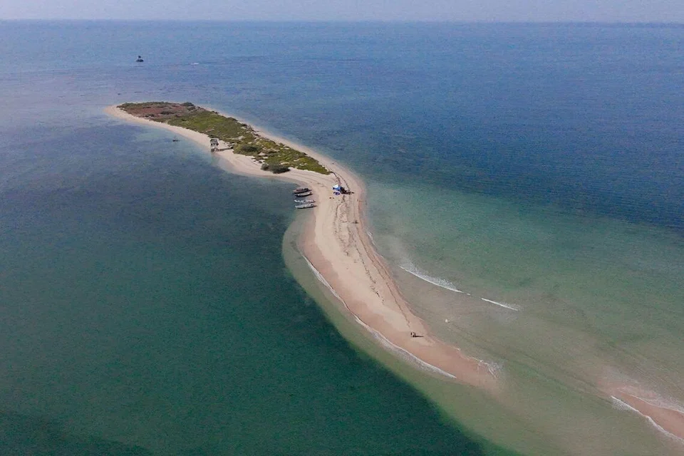
Kariyachalli Island in the Gulf of Mannar has lost a major portion of its landmass due to coastal erosion and rising sea levels. Tamil Nadu is undertaking restoration measures by deploying 8,500 artificial coral reef modules to protect the island. The initiative is being implemented under the Tamil Nadu SHORE Project, with support from the World Bank.
What are Artificial Coral Reefs?
- Artificial coral reefs are man-made underwater structures placed on the seabed to create habitats for marine organisms and support coral growth.
- Materials Used: They are made using eco-friendly materials such as concrete blocks, limestone, steel structures and specially designed reef modules.
- Purpose: They provide surfaces for coral attachment, shelter for fish and other marine organisms, and help restore degraded marine ecosystems.
- Benefits:
- Promote marine biodiversity by creating habitats for aquatic species.
- Support fish breeding and nursery grounds.
- Help reduce wave energy and coastal erosion in suitable locations.
- Limitations: They cannot fully replace natural coral reefs and require careful site selection, scientific monitoring and maintenance to ensure ecological effectiveness.
About Kariyachalli Island
- Location: It is one of the 21 islands in the Gulf of Mannar Marine National Park region, along the southeastern coast of India, between Rameswaram and Thoothukudi.
- Geographical features: The island has beaches, sand dunes, spits and sandy plains.
- Status: It is an uninhabited island.
- Ecological significance: The Gulf of Mannar contains one of India’s four major coral reef systems and is an ecologically sensitive marine region.
Key Terms
|
Why is Kariyachalli Island Shrinking?
The island is facing rapid loss of land due to multiple environmental factors:
- Coastal erosion: Continuous removal of coastal sediments is reducing the island’s landmass.
- Sea-level rise: Rising sea levels increase the vulnerability of low-lying coastal areas.
- Coral reef degradation: Damaged coral reefs provide less protection against incoming waves.
- Seagrass degradation: Decline in surrounding seagrass meadows further weakens the island’s coastal ecosystem.
Extent of Land Loss
According to a January 2025 report by the Department of Ocean Engineering, IIT Madras:
- The island’s area declined by more than 70% between 1969 and 2024.
- Its original area of 20.85 hectares had been reduced to less than 6 hectares by 2024.
- Around one-third of the coral reefs surrounding the island had undergone bleaching on average.
- The report warned that, if erosion continues at the existing rate, the island could be submerged by 2036.
Tamil Nadu’s Restoration Measures
The Tamil Nadu Government is implementing restoration work under the Tamil Nadu SHORE (Sustainably Harnessing Ocean Resources) Project, with World Bank support. Major interventions include:
- Artificial coral reef modules:
- Deployment of 8,500 multipurpose artificial reef modules.
- Designed by IIT Madras using studies of wave dynamics and seabed depth (bathymetry).
- Intended to reduce wave energy, protect the shoreline and encourage sediment deposition.
- Seagrass restoration: Rehabilitation of around three acres of degraded seagrass beds.
- Blue-carbon assessment: Assessment of the island’s coastal ecosystem for its blue-carbon potential.
Frequently Asked Questions (FAQs)
Q1. What is Kariyachalli Island, and where is it located?
Kariyachalli is an uninhabited island in the Gulf of Mannar Marine National Park region, along India’s southeastern coast, between Rameswaram and Thoothukudi. It features beaches, sand dunes, spits and sandy plains.
Q2. What are artificial coral reefs, and what is their ecological significance?
Artificial coral reefs are man-made underwater structures placed on the seabed to provide habitats for marine organisms and support coral growth. They promote biodiversity, provide fish breeding grounds and help reduce wave energy and coastal erosion.
Q3. Why is Kariyachalli Island shrinking?
The island is experiencing land loss due to coastal erosion, rising sea levels, coral reef degradation and declining seagrass meadows. These factors weaken natural coastal protection and increase its vulnerability to waves.
Q4. What is the extent of land loss on Kariyachalli Island?
According to a January 2025 IIT Madras report, the island lost more than 70% of its area between 1969 and 2024, shrinking from 20.85 hectares to less than 6 hectares. It could be submerged by 2036 if erosion continues at the existing rate.
Q5. What restoration measures has Tamil Nadu undertaken to protect Kariyachalli Island?
Under the Tamil Nadu SHORE Project, with World Bank support, the government is deploying 8,500 artificial reef modules, restoring around three acres of degraded seagrass beds and assessing the island’s blue-carbon potential.