
Context
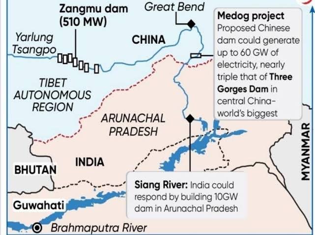
The proposed 11,000 MW Siang Upper Multipurpose Project (SUMP) in Arunachal Pradesh faces opposition from the Adi tribal community over concerns about displacement and loss of ancestral land and cultural heritage. The project has also gained strategic importance amid China’s upstream hydropower development on the Yarlung Tsangpo River.
About the Project
- Location: Proposed on the Siang River in Arunachal Pradesh (part of the Brahmaputra river system).
- Capacity: Around 11,000 MW (Megawatt) of installed hydropower capacity.
- Objectives: Hydropower generation, flood moderation, and water management.
- Strategic Context: Serves as a strategic response to China’s proposed mega-hydropower project near Medog (Motuo) in Tibet, located upstream of India.
Siang River: Geographical Facts
- Origin: Rises in Tibet, where it is called the Yarlung Tsangpo.
- Course in India: Enters Arunachal Pradesh as the Siang (or Dihang).
- Formation of Brahmaputra: Meets the Dibang and Lohit rivers in Assam to form the Brahmaputra.
- River Basin: Part of the transboundary Brahmaputra basin, shared by China, India, and Bangladesh.
Importance of Large Hydropower Projects
- Energy Security: Reduces dependence on fossil fuels and supports non-fossil electricity generation.
- Grid Stability: Reservoir-based hydropower provides flexible power to balance variable solar and wind energy.
- Flood Moderation: Reservoir storage regulates downstream water flow and lowers flood peaks.
- Regional Development: Develops roads, power networks, and local jobs, improving connectivity in remote areas.
- Water Security: Helps cushion sudden changes in downstream river flows caused by upstream activities.
Major Concerns Associated with the Project
- Ecological Impacts
- Forest Submergence: Reservoir creation may submerge forests, wildlife habitats, and farmland, causing biodiversity loss.
- River Ecosystem: Dams alter natural river flows, fish migration, and sediment transport.
- Downstream Impacts: Changes in water flow and silt deposition can harm floodplains, farming, fisheries, and local livelihoods.
- Cumulative Impact: Multiple dams in the same river basin increase combined ecological damage.
- Geological and Disaster Risks
- Seismic Vulnerability: The Eastern Himalayas are highly earthquake-prone, requiring strict seismic safety measures.
- Landslides: Excavation, road construction, deforestation, and slope instability near reservoirs increase landslide risks.
- Extreme Weather: Cloudbursts, heavy rainfall, and GLOFs (Glacial Lake Outburst Floods) threaten dams and downstream villages.
- Reservoir-Induced Seismicity: Large reservoirs can alter underground pressure and potentially trigger earthquakes.
- Socioeconomic and Cultural Concerns
- Displacement: Submergence may affect villages, farmland, community forests, and traditional livelihood resources.
- Livelihood Loss: Reduced access to farmland and common resources lowers household incomes.
- Cultural Heritage: The indigenous Adi community has deep spiritual ties with the Siang River; submergence threatens ancestral burial grounds, sacred sites, and traditions.
- Unequal Benefits: Wider regions gain electricity and infrastructure, while local communities bear the social and environmental costs.
- Governance and Institutional Challenges
- Community Consultation: Weak public participation and ignoring customary land rights fuel local opposition.
- Trust Deficit: Disagreements between authorities and communities delay work and raise social tensions.
- Impact Assessment: Project-level EIA (Environmental Impact Assessment) studies often miss cumulative, downstream, and long-term impacts.
- Rehabilitation: Cash compensation alone cannot restore lost livelihoods, community networks, and cultural identity.
- Coordination: Effective execution needs smooth coordination among agencies handling land acquisition, clearances, dam safety, and rehabilitation.
- Strategic Dimension: China’s Medog Hydropower Project
- Upstream Water Control: China’s mega-dam on the Yarlung Tsangpo raises concerns over potential diversion or reduction of downstream water flows into India, especially during dry seasons.
- Artificial Flood Risks: Sudden water releases or upstream dam failures—triggered by earthquakes or GLOFs (Glacial Lake Outburst Floods)—could cause severe downstream flooding in Arunachal Pradesh and Assam.
- Limited Buffering Capacity: While SUMP (Siang Upper Multipurpose Project) can help moderate floods, it cannot fully offset massive upstream water releases.
- Weak Hydrological Data Sharing: Lack of timely sharing of river flow and rainfall data by China weakens India’s flood forecasting and early-warning systems.
- Strategic vs. Local Dilemma: Over-prioritising strategic projects to counter China risks sidelining local ecological safety and tribal rights, sparking local protests.
Way Forward
- Basin-Wide Assessment: Conduct cumulative environmental impact assessments covering biodiversity, sediment movement, and upstream–downstream effects.
- Disaster-Resilient Design: Account for earthquakes, landslides, GLOFs, and extreme rainfall in dam design and safety planning.
- Community Participation: Ensure meaningful consultation with the Adi community, respecting customary land rights, sacred sites, and traditional institutions.
- Rehabilitation & Benefit Sharing: Provide fair compensation, livelihood restoration, skill training, and equitable local benefits.
- Transparent Governance: Strengthen independent environmental scrutiny, inter-agency coordination, and grievance redressal.
- Transboundary Cooperation: Improve India–China hydrological data sharing, early-warning systems, and flood management cooperation.
- Alternative Assessment: Examine less disruptive project designs and alternative energy options before finalising the project.
FAQs
Q1. What is the Siang Upper Multipurpose Project?
Ans. A proposed 11,000 MW hydropower project in Arunachal Pradesh for electricity generation, flood moderation and water management.
Q2. Why is the Siang project strategically important?
Ans. It could help India manage some downstream flows amid China’s hydropower development on the Yarlung Tsangpo River.
Q3. Which tribal community has opposed the project and why?
Ans. The Adi community, due to concerns over displacement, loss of ancestral land and sacred sites, and inadequate consultation.
Q4. What is a cumulative environmental impact assessment?
Ans. It assesses the combined environmental effects of multiple projects and activities across a river basin or ecosystem.