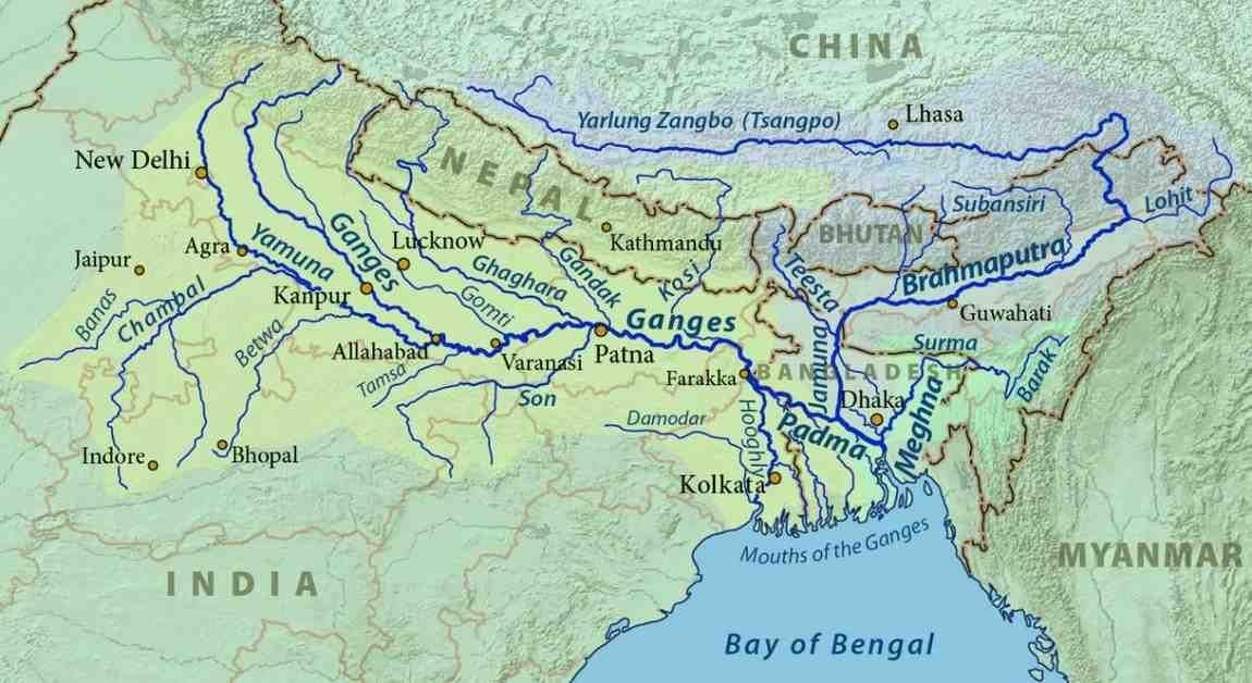
The Ganga River System, also known as the Ganges, is the largest and most sacred river network in India. It is a transboundary lifeline that flows through the heart of Northern India and into Bangladesh, supporting over 400 million people. More than just a water body, the Ganga is the cultural, spiritual, and economic backbone of the Indo-Gangetic Plain.
From the high-altitude glaciers of the Himalayas to the world’s largest delta in the Bay of Bengal, the Ganga basin covers approximately 26% of India’s landmass, influencing agriculture, biodiversity, and urban development across multiple states.
The Origin: From Bhagirathi to Ganga
The Ganga does not begin as a single stream but as a confluence of several Himalayan rivers.
- Gangotri Glacier: The primary source is the Gangotri Glacier in the Uttarkashi district of Uttarakhand. At its source, the river is called the Bhagirathi.
- The Five Prayags: As the Bhagirathi descends, it meets other glacial streams. The most significant confluence is at Devprayag, where the Bhagirathi meets the Alaknanda. From this point forward, the combined flow is officially known as the Ganga.
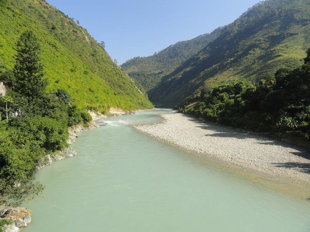
- Journey through the Plains: The river enters the northern plains at Haridwar and flows eastward for approximately 2,525 km.
Ganga River System Map and Course
The Ganga flows through five major Indian states: Uttarakhand, Uttar Pradesh, Bihar, Jharkhand, and West Bengal. Its journey is divided into three distinct stages:
- Upper Course: High-velocity flow through the mountains of Uttarakhand.
- Middle Course: Flow through the fertile plains of Uttar Pradesh and Bihar, where it receives its largest tributaries.
- Lower Course: In West Bengal, the river bifurcates into the Bhagirathi-Hooghly (flowing through Kolkata) and the Padma (entering Bangladesh).
The Tributary Network: Left Bank vs. Right Bank
The Ganga is fed by an intricate network of rivers originating from both the Himalayas (North) and the Peninsular Plateau (South).
I. Major Right-Bank Tributaries (South)
These rivers primarily join the Ganga from the southern side.
| Name | Origin | Key Details |
| Yamuna | Yamunotri Glacier | The largest and longest tributary. Meets Ganga at Prayagraj (Triveni Sangam). |
| Son | Amarkantak Plateau | The second-largest southern tributary; joins near Patna. |
| Punpun | Palamu (Jharkhand) | Flows northeast and merges at Fatuha (Bihar). |
| Damodar | Chota Nagpur Plateau | Known as the “Sorrow of Bengal” historically; joins the Hooghly River. |
| Tamsa (Tons) | Kaimur Range | Merges with the Ganga in Uttar Pradesh. |
II. Major Left-Bank Tributaries (North)
These are largely perennial rivers originating in the Himalayas.
| Name | Origin | Key Details |
| Ramganga | Doodhatoli Range | The first major left-bank tributary; joins near Kannauj. |
| Gomti | Fulhaar Jheel | A plain-originating river; flows through Lucknow. |
| Ghaghara | Mapchachungo Glacier | The largest tributary by volume; joins near Chhapra. |
| Gandak | Nepal Himalayas | Known as ‘Narayani’ in Nepal; joins at Sonpur. |
| Kosi | Tibet/Nepal Border | Known as “Bihar’s Sorrow” due to frequent course changes and flooding. |
Key Tributaries
The Yamuna: The Primary Companion
The Yamuna flows parallel to the Ganga for nearly 1,376 km. It is a vital river for Delhi, Haryana, and Uttar Pradesh. Its own tributaries include the Chambal, Betwa, and Ken, which bring water from the Peninsular plateau into the Ganga system.
The Kosi:
The Kosi is notorious for its heavy silt load. It frequently shifts its course, leading to devastating floods in Northern Bihar. It is formed by the confluence of seven streams, popularly known as Saptakoshi.
The Falgu (Niranjana):
Flowing through Gaya, the Falgu is sacred to both Hindus and Buddhists. It is on the banks of this river (at Bodh Gaya) that Lord Buddha attained enlightenment.
The Ganga-Brahmaputra Delta: The Sundarbans
Before entering the Bay of Bengal, the Ganga merges with the Brahmaputra (known as Jamuna in Bangladesh) and the Meghna. Together, they form the Ganga-Brahmaputra Delta, the largest in the world.
- Mangrove Forests: This region is home to the Sundarbans, a UNESCO World Heritage site and the world’s largest mangrove forest.
- The Padma: In Bangladesh, the main branch of the Ganga is called the Padma, which provides critical irrigation for the country’s deltaic plains.
FAQs: Ganga River System
Q1 What is the total length of the Ganga River?
The total length of the Ganga is approximately 2,525 km, making it the longest river in India.
Q2 Where do Alaknanda and Bhagirathi meet?
They meet at Devprayag in Uttarakhand, which is considered the official starting point of the name ‘Ganga’.
Q3 Which is the largest tributary of the Ganga?
In terms of length and volume, the Yamuna is the largest tributary.
Q4 Why is the Kosi River called the “Sorrow of Bihar”?
Because it carries massive amounts of silt, causing it to change its course frequently, which leads to unpredictable and catastrophic flooding in Bihar.
Q5 Which river joins the Ganga at Prayagraj?
The Yamuna joins the Ganga at Prayagraj (formerly Allahabad) at the holy confluence known as Sangam.
Q6 What is the source of the Ganga?
The primary source is the Gangotri Glacier at Gaumukh, where the river is initially known as the Bhagirathi.
Q7 Which states are covered by the Ganga basin?
The basin covers Uttarakhand, Uttar Pradesh, Bihar, Jharkhand, and West Bengal.
Q8 What is the name of the Ganga in Bangladesh?
Upon entering Bangladesh, the Ganga is known as the Padma.
Q9 Which city is known as the “Gateway to the Ganga”?
Haridwar is often called the Gateway to the Ganga as it is the point where the river leaves the mountains and enters the plains.
Q10 What is the National River of India?
The Ganga was officially declared the National River of India in 2008.