
1. Baltic Sea
Why in the News?
- The Baltic Sea region has witnessed a sharp rise in GPS interference (jamming and spoofing) affecting aviation and maritime navigation.
- According to Sweden’s Transport Agency, incidents in Swedish airspace rose from 55 in 2023 to 733 in 2025 (till August 18).
- Sweden has attributed the interference to Russia, with disruptions now spreading over both land and sea areas.
- Six Baltic Sea countries, Sweden, Estonia, Finland, Latvia, Lithuania, and Poland, raised the issue with the ICAO Council, which expressed grave concern and urged Russia to stop the interference.
- A recent case included GPS jamming of EU chief Ursula von der Leyen’s aircraft while landing in Bulgaria.
About Baltic Sea
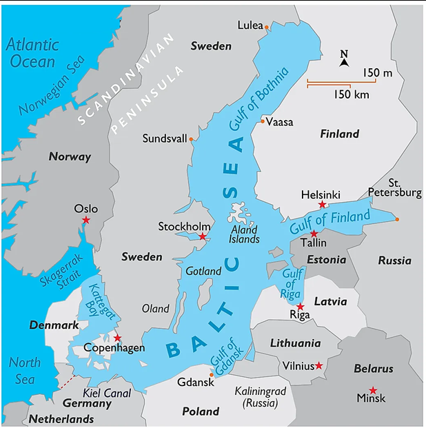
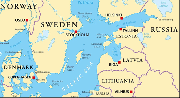
- The Baltic Sea, part of the Atlantic Ocean system, lies in Northern Europe.
- It is considered the youngest sea on Earth, having formed around 10,000–15,000 years ago after the last Ice Age when glaciers receded.
- The sea extends roughly 1,600 km in length and 193 km in width, covering an area of nearly 77 lakh sq. km.
- Coastline & Countries: With a coastline of about 8,000 km, it is bordered by Sweden, Finland, Estonia, Latvia, Lithuania, Poland, Germany, Denmark, and Russia.
- Connectivity:
- Linked to the Atlantic Ocean through the Danish Straits.
- Connected to the White Sea via the White Sea Canal.
- Connected to the North Sea (German Bight) through the Kiel Canal.
- Important Gulfs:
- Gulf of Bothnia (north)
- Gulf of Finland (east)
- Gulf of Riga (south-east)
- The Baltic Sea is the largest brackish inland water body in the world. Its low salinity is due to shallow depth and heavy inflow of freshwater from rivers.
- Around 60 rivers drain into it, with the Neva River being the largest contributor.
- Islands: The sea has more than 20 islands and archipelagos; Gotland (Sweden) is the largest.
- Environmental Concern: The sea frequently experiences Harmful Algal Blooms (HABs), making it one of the major ecological issues in the region.
2. South China Sea
Why in the News?
- China’s Navy carried out a so-called “routine patrol” in the South China Sea.
- This coincided with the Philippines completing joint naval drills with Australia, Canada, and the U.S. in the same region.
- The event reflects the ongoing maritime tensions in the South China Sea, where several countries contest China’s expansive claims.
About South China Sea
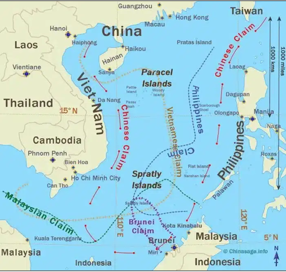
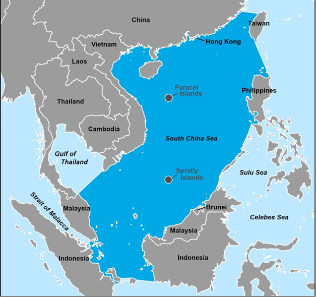
- The South China Sea is a marginal sea of the western Pacific Ocean, lying adjacent to the Southeast Asian mainland.
- It covers an area of about 68 million sq. km (1.42 million sq. miles) with an average depth of 1,212 m (3,976 ft).
- Borders: China, Taiwan, the Philippines, Malaysia, Brunei, Indonesia, and Vietnam.
- Southern limit: Seabed ridge between Sumatra and Borneo.
- Northern limit: Line from northern Taiwan to China’s Fujian coast (Taiwan Strait).
- Connections:
- With East China Sea via Taiwan Strait.
- With Philippine Sea via Luzon Strait.
- Together with the East China Sea, it forms the China Seas.
- Two major disputed archipelagos:
- Paracel Islands (under Chinese control).
- Spratly Islands (claimed by multiple states).
- Climate: Tropical monsoon climate, with seasonal variations heavily influenced by monsoons.
- Strategic Importance
- One of the busiest sea lanes in the world (2nd most used).
- A critical route for crude oil shipments from the Persian Gulf and Africa, passing through the Strait of Malacca to reach Singapore, Hong Kong, Taiwan, South Korea, Japan, and beyond.
- Major Ports on the South China Sea: Hong Kong (China), Singapore and Kaohsiung (Taiwan).