- Courses
- GS Full Course 1 Year
- GS Full Course 2 Year
- GS Full Course 3 Year
- GS Full Course Till Selection
- Answer Alpha: Mains 2025 Mentorship
- MEP (Mains Enrichment Programme) Data, Facts
- Essay Target – 150+ Marks
- Online Program
- GS Recorded Course
- Polity
- Geography
- Economy
- Ancient, Medieval and Art & Culture AMAC
- Modern India, Post Independence & World History
- Environment
- Governance
- Science & Technology
- International Relations and Internal Security
- Disaster Management
- Ethics
- NCERT Current Affairs
- Indian Society and Social Issue
- NCERT- Science and Technology
- NCERT - Geography
- NCERT - Ancient History
- NCERT- World History
- NCERT Modern History
- CSAT
- 5 LAYERED ARJUNA Mentorship
- Public Administration Optional
- ABOUT US
- OUR TOPPERS
- TEST SERIES
- FREE STUDY MATERIAL
- VIDEOS
- CONTACT US
PLACES IN NEWS 2nd MAY 2025
PLACES IN NEWS 2nd MAY 2025

Vembanad Lake
Why in news?
a. Inspired by the Namami Gange Programme, Alappuzha District Administration launched the Vembanad Lake Rejuvenation Project to restore the ecosystem.
About Vembanad Lake:
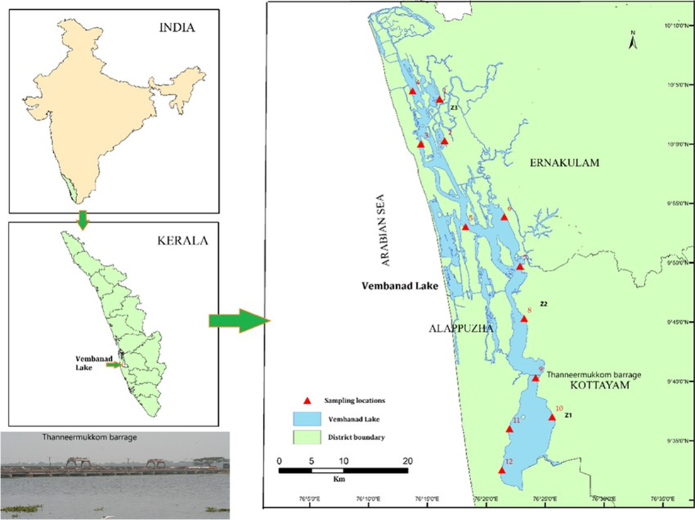
- Location and Geography:
- Vembanad Lake is located in Kerala.
- It is the longest lake in India and the largest in Kerala, stretching about 96.5 km in length and 14 km in width.
- With an area of approximately 230 sq. km, the lake spans three districts—Alappuzha, Kottayam, and Ernakulam.
-
- Known by different names across regions—Punnamada Lake in Alappuzha, Vembanad Lake in Kottayam, and Kochi Lake in Ernakulam—it is surrounded by important islands like Pathiramanal, Perumbalam, and Willingdon Island.
- The lake lies at sea level, separated from the Laccadive Sea by a narrow barrier island.
- It is fed by 10 rivers, including major ones like Periyar, Pamba, Meenachil, Muvattupuzha, Manimala, and Achenkovil, draining a basin of 15,770 sq. km, or 40% of Kerala's area.
- A significant hydro-engineering structure, the Thanneermukkom saltwater barrier, divides the lake into brackish and freshwater zones, supporting agriculture in the Kuttanad region—the lowest altitude in India and one of the few places in the world where farming is done below sea level.
- Ecological Significance:
- Vembanad is part of the Vembanad-Kol Wetland, which was designated a
Ramsar Site in 2002 for its global ecological importance.
-
- It is the largest Ramsar site in Kerala and supports a vast biodiversity, including over 20,000 waterfowl, making it the third largest waterfowl habitat in India.
- The lake also serves as an ideal breeding ground for shrimp and hosts the
Kumarakom Bird Sanctuary, a crucial habitat for migratory birds.
-
- Despite its importance, Vembanad faces severe ecological threats due to pollution, weed infestation, and land reclamation, which has reduced its area to just 37% of its original extent.
- Conservation efforts are underway under the National Wetlands Conservation Programme.
Cotigao Wildlife Sanctuary
Why in news?
After decades without power, Keri hamlet in Goa’s remote Cotigao Wildlife Sanctuary is finally getting electricity connectivity.
About Cotigao Wildlife Sanctuary:
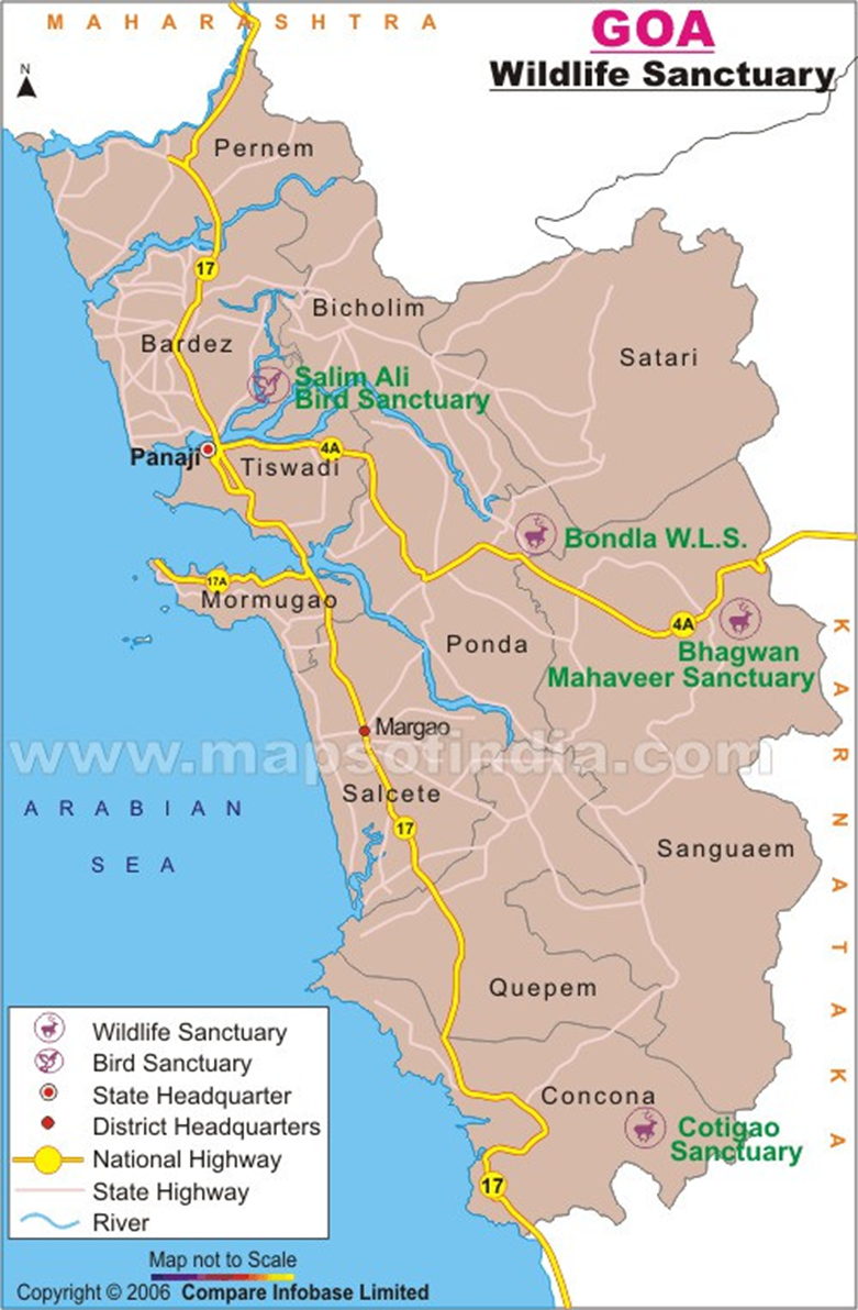
- Location and Geography:
- Cotigao Wildlife Sanctuary is located in Canacona Taluka, South Goa district, in the state of Goa, India.
-
- Established in 1968, the sanctuary covers a lush green area in the Western Ghats and is the second-largest wildlife sanctuary in Goa.
- At the entrance, an eco-tourism complex offers facilities like a nature interpretation centre, cottages, a canteen, a library, and a rescue centre, making it visitor-friendly.
- The sanctuary is known for its dense forest canopy with trees soaring up to 30 metres in height.
- A unique feature is the 25-metre-high treetop watchtower overlooking a
watering hole, best visited during dawn and dusk for wildlife sightings.
-
- It also includes eight nature trails ranging from 500 metres to 5 kilometres, ideal for trekking and exploration.
- Flora and Fauna:
- The sanctuary hosts a mix of moist deciduous, semi-evergreen, and evergreen forests.
- It is home to rare species like the flying squirrel, slender loris, Indian pangolin, mouse deer, and four-horned antelope.
- Reptiles include the Malabar pit viper, golden-back gliding snake, and
Malabar tree toad.
-
- Birdwatchers can spot the Malabar trogon, white-bellied woodpecker, draco (flying lizard), and speckled piculet.
- Local tribal communities, such as the Velip and Kunbil, reside in and around the sanctuary, offering cultural insights to visitors.
Kamlang Tiger Reserve
Why in news?
a. On April 29, 2025, Arunachal Pradesh Chief Secretary Manish Kumar Gupta launched the official website of Kamlang Tiger Reserve, enhancing digital access to this ecologically significant sanctuary.
About Kamlang Tiger Reserve:
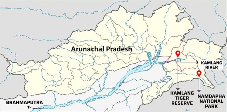
- Location and Geography:
- Kamlang Tiger Reserve is located in the Lohit district of Arunachal Pradesh, in the northeastern region of India.
- Established in 1989 as a wildlife sanctuary, it was later designated as the 50th Tiger Reserve of India and declared an eco-sensitive zone in 2024.
- Spanning 783 square kilometres, the sanctuary lies in the south-eastern part of Lohit, named after the Kamlang River that flows through it.
- It shares its southern boundary with Namdapha National Park and is bordered by the Lang River to the north.
- The sanctuary includes notable landmarks like the sacred Parshuram Kund and the picturesque Glow Lake, located at 5,000 feet, accessible only through trekking.
- The nearest towns are Wakro and Namsai, with Tinsukia and Dibrugarh
serving as the closest railhead and airport, respectively.
- Flora and Fauna:
- Kamlang lies in both tropical and sub-tropical climatic zones, hosting diverse ecosystems.
- Tropical wet evergreen forests dominate the foothills, while alpine vegetation
is found in the upper reaches, like Daphabum peak.
-
- The reserve is also rich in herbs, shrubs, bamboos and features 49 species of orchids.
- Faunally, it is home to all four major big cats of India — tiger, leopard, clouded leopard, and snow leopard.
-
- Other mammals include elephants, wild boars, sambar, barking deer, and
flying squirrels.
-
- Six primate species, such as the rhesus macaque and eastern hoolock gibbon, also inhabit the reserve. With 61 mammal, 105 bird, and 20 reptile species, Kamlang is a vital part of India’s biodiversity heritage.
- Six primate species, such as the rhesus macaque and eastern hoolock gibbon, also inhabit the reserve. With 61 mammal, 105 bird, and 20 reptile species, Kamlang is a vital part of India’s biodiversity heritage.
Tonga
Why in news?
a. The 2022 Tonga eruption injected seawater into the stratosphere and sulfur into oceans, altering atmospheric chemistry and marine ecosystems.
About Tonga:
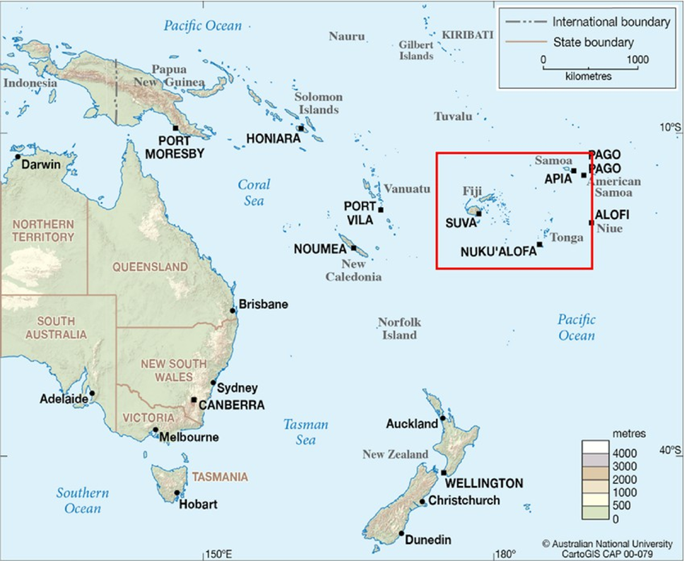
- Location and Geography:
- Tonga is a Polynesian island nation located in the South Pacific Ocean, consisting of over 170 islands, of which around 36 are inhabited.
- It lies to the northeast of New Zealand and is part of the Ring of Fire, a seismically active zone known for frequent earthquakes and volcanic eruptions.
- One of its most significant volcanoes, Hunga Tonga–Hunga Ha'apai, is a
submarine volcano situated about 65 km north of Tonga’s main island.
- 2022 Volcanic Eruption and Recent Study:
- In January 2022, the Hunga Tonga–Hunga Ha'apai volcano experienced one of the largest eruptions in modern history.
- The eruption was powerful enough to send an estimated 3 billion tons of water vapour into the atmosphere in just one hour, reaching altitudes up to 57 km, impacting both the stratosphere and mesosphere.
- While submarine volcanism was previously considered insignificant in climate studies due to limited atmospheric sulfur emissions, this eruption challenged that assumption.
- A recent study found that the eruption also released around 20 million tons of sulfur dioxide, most of which dissolved into seawater at depths between 300 and 1,100 meters.
- This combination of water vapour and sulfur emissions has had global climate impacts, including a cooling effect in the Southern Hemisphere.
- The study emphasises that submarine eruptions like Hunga can alter atmospheric chemistry, affect marine ecosystems, and pose hazards like tsunamis and damage to undersea cables.
- Researchers are now working to better understand the environmental and climatic implications of such underwater volcanic events in the southwestern Pacific.
|
Also Read |
|
UPSC Foundation Course |
|
| UPSC Monthly Magazine | CSAT Foundation Course |


PLACES IN NEWS 20th June 2025

PLACES IN NEWS 19th June 2025

PLACES IN NEWS 17th June 2025
Karol Bagh Metro Pillar No. 112, Above Domino's, 22B, First Floor, New Delhi - 110060
Very Important Instruction For Any Issue, Student Must Produce His/Her Fee Receipt. Without Fee Receipt, It Will Not Be Possible To Track Your Details. If You Have Been Given Any Special Consideration, You Must Keep That In Writing And Produce In Case Of Conflict.
Copyright © 2024-2026 ENSURE IAS. All rights reserved.