- Courses
- GS Full Course 1 Year
- GS Full Course 2 Year
- GS Full Course 3 Year
- GS Full Course Till Selection
- Answer Alpha: Mains 2025 Mentorship
- MEP (Mains Enrichment Programme) Data, Facts
- Essay Target – 150+ Marks
- Online Program
- GS Recorded Course
- Polity
- Geography
- Economy
- Ancient, Medieval and Art & Culture AMAC
- Modern India, Post Independence & World History
- Environment
- Governance
- Science & Technology
- International Relations and Internal Security
- Disaster Management
- Ethics
- NCERT Current Affairs
- Indian Society and Social Issue
- NCERT- Science and Technology
- NCERT - Geography
- NCERT - Ancient History
- NCERT- World History
- NCERT Modern History
- CSAT
- 5 LAYERED ARJUNA Mentorship
- Public Administration Optional
- ABOUT US
- OUR TOPPERS
- TEST SERIES
- FREE STUDY MATERIAL
- VIDEOS
- CONTACT US
PLACES IN NEWS 20th June 2025
PLACES IN NEWS 20th June 2025
20-06-2025

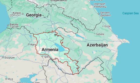
1. Armenia
Why in the News?
- India’s Ministry of External Affairs carried out Operation Sindu to bring back Indian students and citizens from Tehran.
- They were safely evacuated through Armenia.
- This was done because of increasing tensions between Israel and Iran.
What are the Key Highlights?
- Location & Borders
- Continent: Asia (Transcaucasia / South Caucasus)
- Coordinates: 40° N latitude and 45° E longitude
- Landlocked Country
- Borders:
- North: Georgia
- East: Azerbaijan
- South: Iran
- West: Turkey
- Area & Size
- Total Area: 29,743 sq. km (slightly smaller than Belgium)
- Strategic Location: Between Europe and Asia, part of the historical Silk Road
- Topography
- Highly mountainous: over 90% of Armenia lies above 1,000 meters
- Dominated by the Lesser Caucasus Mountains
- Key features:
- Mount Aragats: Highest point (4,090 meters)
- Ararat Valley: Most fertile and densely populated region
- Lake Sevan: One of the largest freshwater, high-altitude lakes in the world (Approximate 1,900 m above sea level)
- Climate
- Continental climate: Hot summers, cold winters
- Influenced by elevation and topography
- Low precipitation: Especially in plains and valleys
- Snowfall common in winter, especially in highlands
- Rivers & Lakes
- Key rivers:
- Hrazdan River
- Aras River (forms border with Turkey and Iran)
- Major Lake:
- Lake Sevan (covers ~5% of Armenia's area)
- Key rivers:
- Natural Resources
- Copper, molybdenum, gold
- Small deposits of zinc, aluminum, and other minerals
- Forests cover approximately 11% of the land
- Environmental Issues
- Deforestation
- Water pollution (especially Lake Sevan)
- Soil erosion due to overgrazing
- Earthquake-prone region (e.g., 1988 Spitak earthquake)
- Geopolitical Importance
- Situated at the crossroads of Eastern Europe and Western Asia
- Close to major regional powers: Turkey, Iran, Russia
- Disputes with Azerbaijan over Nagorno-Karabakh region
- Urban Geography
- Capital: Yerevan (in Ararat Valley)
- Other cities: Gyumri, Vanadzor
- Most urban settlements located in western and central Armenia
- Geographical Challenges
- Landlocked: Hinders trade and connectivity
- Hostile borders: Closed borders with Turkey and Azerbaijan
- Earthquakes: Seismic zone
- Rugged terrain: Limits agriculture and infrastructure development
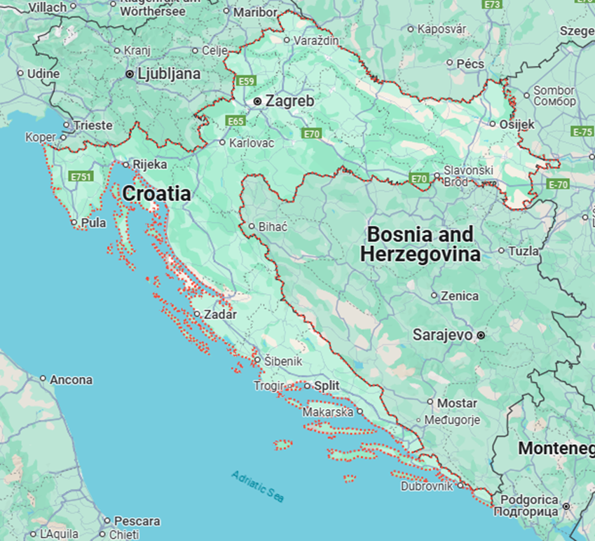
2. Croatia
Why in the News?
- The Prime Minister of India reached Croatia. He is the first Indian Prime Minister to visit the country. This visit is part of his tour to three countries.
- He came after attending the G7 Summit in Canada.
What are the Key Highlights?
- Location & Borders
- Continent: Europe (Southeastern Europe, part of the Balkans)
- Latitude & Longitude: 45°N, 16°E
- Strategic Location: Along the Adriatic Sea, gateway between Central Europe and the Mediterranean
- Borders:
- North: Slovenia and Hungary
- East: Serbia
- South: Bosnia & Herzegovina and Montenegro
- West: Adriatic Sea (opposite Italy)
- Area & Size
- Total Area: ~56,594 sq. km
- Slightly smaller than West Bengal
- Coastline: ~1,800 km (including over 1,000 islands and islets)
- Topography
- Three main geographic zones:
- Pannonian Plain (North & East):
- Flat, fertile land — agriculture dominant
- Pannonian Plain (North & East):
- Dinaric Alps (Central region):
- Mountainous and rugged
- Dinara Peak: Highest point (1,831 meters)
- Adriatic Coast (West):
- Narrow coastal strip with limestone cliffs and karst topography
- Scenic, highly indented coastline with many islands
- Three main geographic zones:
- Climate
- Diverse climate due to varied topography:
- Continental Climate: In Pannonian region (cold winters, hot summers)
- Mediterranean Climate: Along Adriatic coast (mild, wet winters; hot, dry summers)
- Mountain Climate: In Dinaric Alps (snowfall common)
- Diverse climate due to varied topography:
- Rivers & Lakes
- Major Rivers:
- Sava River: Flows through capital Zagreb
- Drava River: Northern border
- Danube River: Eastern border with Serbia
- Kupa River
- Plitvice Lakes: UNESCO World Heritage site, known for cascading lakes and waterfalls
- Major Rivers:
- Natural Resources
- Bauxite, oil, natural gas, coal, limestone, salt
- Fertile soil in eastern plains
- Rich biodiversity, especially in karst regions
- Environmental Features
- Karst Topography:
- Limestone landscapes with sinkholes, caves, and underground rivers
- Covers over half of Croatia
- National Parks:
- Plitvice Lakes, Krka, Paklenica, and others
- Biodiversity Hotspot: Part of the Dinaric Alps and Mediterranean bioregions.
- Seismic Activity
- Croatia is located in a moderate seismic zone
- Earthquakes occasionally affect Zagreb and coastal areas
- Karst Topography:
- Urban Geography
- Capital: Zagreb (northwest, inland, on the Sava River)
- Other major cities:
- Split (coastal, Dalmatia region)
- Rijeka (main seaport)
- Dubrovnik (historic coastal city)
- Urbanization is concentrated along the coast and in river valleys
- Geopolitical Importance
- Member of EU and NATO
- Gateway to the Balkans
- Maritime significance: Important ports on the Adriatic Sea
- Proximity to Italy, Austria, and Central Europe increases trade potential

PLACES IN NEWS 20th June 2025
PLACES IN NEWS 19th June 2025

PLACES IN NEWS 17th June 2025
Karol Bagh Metro Pillar No. 112, Above Domino's, 22B, First Floor, New Delhi - 110060
Very Important Instruction For Any Issue, Student Must Produce His/Her Fee Receipt. Without Fee Receipt, It Will Not Be Possible To Track Your Details. If You Have Been Given Any Special Consideration, You Must Keep That In Writing And Produce In Case Of Conflict.
Copyright © 2024-2026 ENSURE IAS. All rights reserved.