- Courses
- GS Full Course 1 Year
- GS Full Course 2 Year
- GS Full Course 3 Year
- GS Full Course Till Selection
- Answer Alpha: Mains 2025 Mentorship
- MEP (Mains Enrichment Programme) Data, Facts
- Essay Target – 150+ Marks
- Online Program
- GS Recorded Course
- Polity
- Geography
- Economy
- Ancient, Medieval and Art & Culture AMAC
- Modern India, Post Independence & World History
- Environment
- Governance
- Science & Technology
- International Relations and Internal Security
- Disaster Management
- Ethics
- NCERT Current Affairs
- Indian Society and Social Issue
- NCERT- Science and Technology
- NCERT - Geography
- NCERT - Ancient History
- NCERT- World History
- NCERT Modern History
- CSAT
- 5 LAYERED ARJUNA Mentorship
- Public Administration Optional
- ABOUT US
- OUR TOPPERS
- TEST SERIES
- FREE STUDY MATERIAL
- VIDEOS
- CONTACT US
PLACES IN NEWS 2nd APRIL 2025
PLACES IN NEWS 2nd APRIL 2025
02-04-2025

Gandhi Sagar Wildlife Sanctuary
Why in news?
- Gandhi Sagar Wildlife Sanctuary in Mandsaur, Madhya Pradesh, is preparing to host cheetahs under India's ongoing cheetah reintroduction program.
About Gandhi Sagar Wildlife Sanctuary:
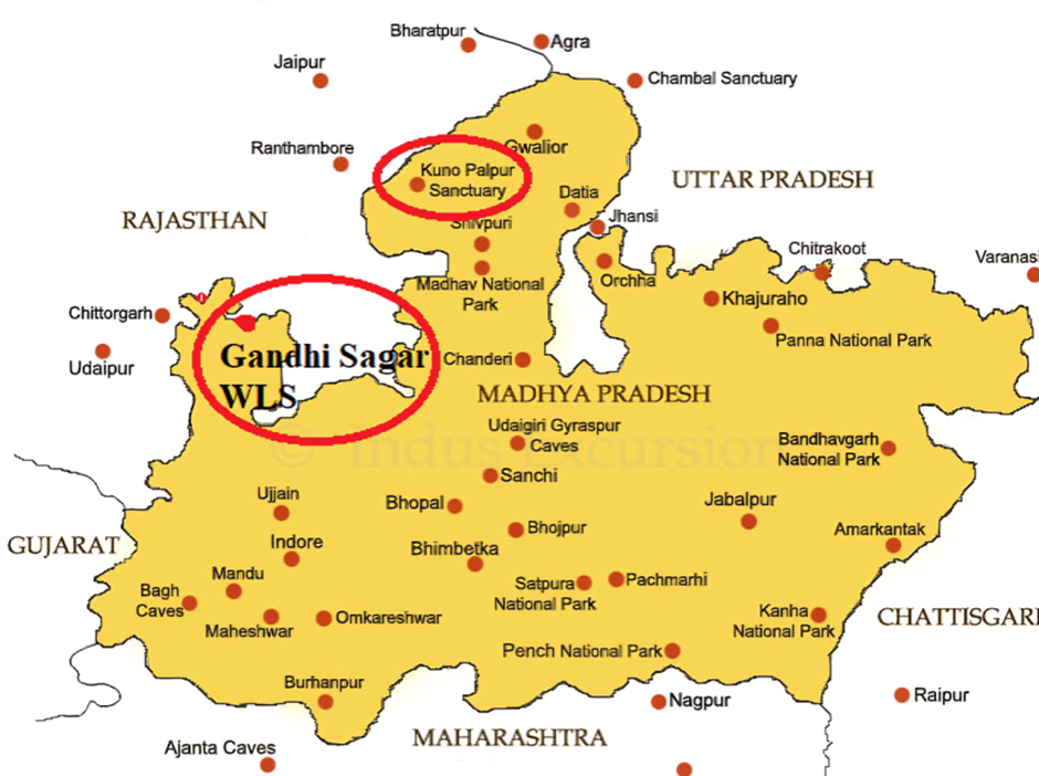
- Location:
- Gandhi Sagar Wildlife Sanctuary (GSWS) is situated on the northern boundary of the Mandsaur and Neemuch districts in Madhya Pradesh, India.
- It spans an area of 368.62 km² (142.32 sq mi) and shares a border with Rajasthan.
- The Chambal River flows through the sanctuary, dividing it into two parts: the western part in Neemuch district and the eastern part in Mandsaur district.
- The sanctuary lies within the Khathiar-Gir dry deciduous forests ecoregion, featuring diverse landscapes of wooded hills and grasslands.
- Flora and Fauna:
- The sanctuary’s vegetation consists mainly of dry, mixed deciduous forests and flat grasslands near the Gandhi Sagar Dam submergence area.
- Major tree species include Khair (Acacia catechu), Salai, Kardhai, Dhawda, Tendu, and Palash.
- The primary wildlife species found in GSWS include:
- Deer species: Chinkara (Indian gazelle), nilgai, and sambar.
- Carnivores: Indian leopard and Indian wild dog.
- Other fauna: langur, peacock, otter, and mugger crocodile.
Bannerghatta National Park
Why in news?
- Bannerghatta National Park intensifies wildlife protection efforts by launching an anti-snare drive to prevent poaching and safeguard its biodiversity.
About Bannerghatta National Park:
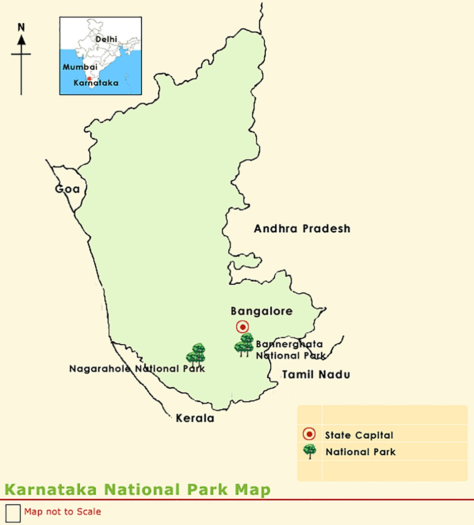
- Location:
- Bannerghatta National Park (BNP) is located in the Bengaluru and Ramanagara districts of Karnataka, India.
- It was established in 1970 and declared a national park in 1974. A part of the park was converted into the Bannerghatta Biological Park in 2002.
- The park covers an area of 260.51 km² and lies in the Anekal range at an elevation of 1,245–1,634 meters.
- BNP is part of an elephant corridor connecting Biligiriranga Hills (BR Hills) and Sathyamangalam Forest, ensuring the movement of large mammals.
- The Suvarnamukhi stream flows through the park, and additional bore wells have been installed to ensure water availability.
- Flora and Fauna:
- The park features moist deciduous forests, scrublands, and artificial forests.
Major tree species include sandalwood, neem, tamarind, bamboo, and eucalyptus. - Fauna in BNP includes:
- Large mammals: Indian elephants, leopards, gaurs, sloth bears, jackals, and wild boars.
- Deer species: spotted deer, barking deer, and Indian gazelle (chinkara).
- Carnivores: Royal Bengal tiger, Indian wolf, striped hyena, and Asiatic lion.
- Reptiles: monitor lizards, cobras, pythons, Russell’s viper, and kraits.
- Birds: Flamingos, pelicans, peacocks, and over 101 recorded bird species.
- Anti-Snare Drive:
- Bannerghatta National Park has launched an anti-snare drive to prevent poaching and illegal wildlife trapping.
- The initiative aims to remove snares and traps set by poachers that endanger animals, particularly tigers, leopards, and elephants.
- Forest officials, NGOs, and local communities are involved in conducting surveillance and dismantling snares.
- The drive is crucial for protecting Bannerghatta’s wildlife, as illegal hunting and habitat destruction pose significant threats.
- It is part of a broader effort to enhance conservation measures, reduce human-wildlife conflicts, and ensure the safety of animals in the park.
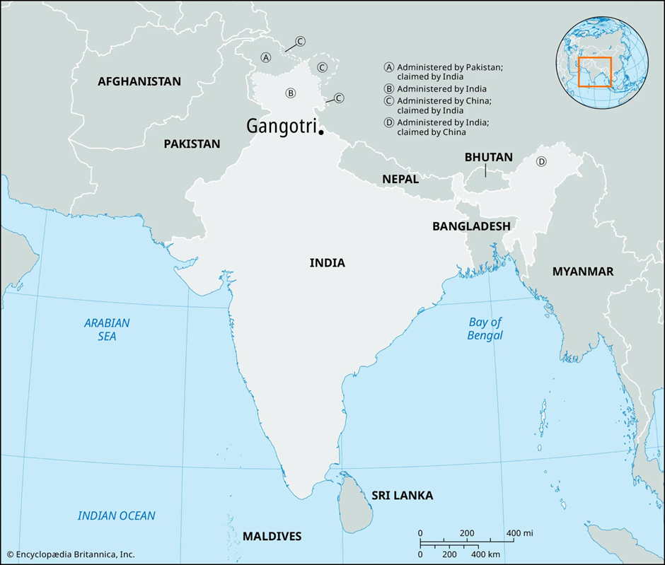
Gangotri National Park
Why in news?
- Gangotri National Park, Uttarakhand, reopens for tourists, offering access to its diverse flora, fauna, and scenic Himalayan landscapes.
About Gangotri National Park:
-
- Location and Geography:
- Gangotri National Park (GNP) is located in the Uttarkashi district of Uttarakhand, India. It was established in 1989 and covers an area of 2,390 km² (920 sq mi).
- The park lies in the upper catchment of the Bhagirathi River and shares its north-eastern boundary with China.
- It falls under the West Himalayan biogeographical zone and features high-altitude landscapes, including glaciers, deep gorges, and steep ridges.
- The Gaumukh Glacier, the origin of the Ganges River, is located within the park. The Gangotri temple, one of Hinduism’s holiest shrines, is also situated nearby.
- The park serves as a crucial ecological corridor, connecting Govind National Park and Kedarnath Wildlife Sanctuary.
- Elevation ranges from 1,800 m to 7,083 m, resulting in diverse ecosystems from subtropical forests to alpine meadows.
- Flora and Fauna:
- The park has Western Himalayan subalpine conifer forests at lower elevations and alpine meadows at higher altitudes.
- Major tree species include deodar, fir, spruce, oak, chir pine, and rhododendrons.
- Gangotri National Park is home to the snow leopard, a top predator of the region.
- Other key mammal species include the Asian black bear, brown bear, musk deer, blue sheep, and Himalayan tahr.
- Over 150 bird species are recorded, including the Himalayan monal, koklass pheasant, snowcock, partridges, and doves.
- The diverse landscape supports a rich biodiversity, making it an important conservation area in the Indian Himalayas.
East Khasi Hills
Why in news?
- BSF apprehended five Bangladeshi infiltrators in East Khasi Hills, Meghalaya, for illegal border crossing.
About East Khasi Hills:
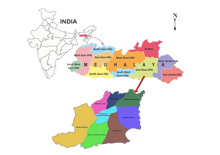
- Location and Geography:
- East Khasi Hills is a district in the state of Meghalaya, India, with Shillong as its headquarters.
- It shares an international border with Bangladesh to the south and is surrounded by West Khasi Hills, Ri-Bhoi, and South West Khasi Hills.
- The district features rugged terrain, deep gorges, waterfalls, and rolling hills, forming part of the Shillong Plateau.
- The Wah Umngot and Umiam rivers are major water bodies, with the Umiam Lake serving as a key hydroelectric source.
- The region experiences high rainfall, misty weather, and cool temperatures, influenced by the Southwest Monsoon.
- Natural Resources:
- East Khasi Hills is rich in limestone, coal, granite, and uranium deposits, making mining a key economic activity.
- The region has extensive forests with medicinal plants, orchids, and bamboo species, supporting the local economy.
- Agriculture and horticulture thrive in the district, with products like betel nut, oranges, pineapples, and ginger.
- Hydropower potential is significant, with projects like Umiam Hydroelectric Plant contributing to energy production.
- Issues of Illegal Migration:
- Due to its porous border with Bangladesh, East Khasi Hills faces persistent issues of illegal migration.
- Infiltrators from Bangladesh enter for livelihood opportunities, land encroachment, and illegal trade.
- The rise in demographic changes, pressure on resources, and potential security threats have led to local discontent.
- Human trafficking, drug smuggling, and cross-border crimes are linked to unregulated migration in the region.
- Government Initiatives to Combat Illegal Migration:
- Border Security Force (BSF) patrols the India-Bangladesh border to prevent illegal crossings.
- The Indo-Bangladesh Border Fence (IBBF) is being constructed to enhance border security.
- Advanced surveillance technologies like drones, night vision cameras, and motion sensors are deployed for monitoring.
- The Meghalaya Residents Safety and Security Act (MRSSA) was enacted to regulate the entry of outsiders and prevent illegal settlements.
- Identification and deportation drives are conducted in coordination with the Bangladesh government.
- The Integrated Check Posts (ICPs) and border outposts are being strengthened to curb unauthorised movements.
Nankai Trough
Why in news?
-
-
- Japan's latest report warns of a potential megaquake and tsunami along the Nankai Trough, potentially causing 298,000 fatalities.
-
About Nankai Trough:
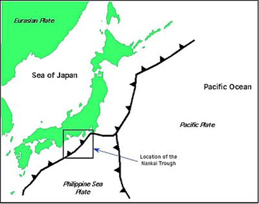
- Location & Geography
- The Nankai Trough is a 900 km (559 mi) long submarine trench located south of Honshu, Japan.
- It extends from Shizuoka Prefecture to the southern tip of Kyushu in the Nankaidō region.
- It is a subduction zone, where the Philippine Sea Plate is moving beneath the Eurasian Plate.
- The region is part of the Pacific Ring of Fire, one of the world’s most tectonically active areas.
- Tectonic Activity & Megaquakes
- The Nankai Megathrust Fault is the main cause of Nankai Trough earthquakes, which occur every 100–200 years.
- The last major earthquake in the region occurred in 1946.
- A megaquake (magnitude 8 or higher) along this fault could trigger a tsunami and cause widespread destruction.
- The Japanese government estimates a 75-82% chance of a megaquake within the next 30 years.
- Megaquake & Tsunami Risk
- A new government report warns that a megaquake and tsunami along the Nankai Trough could cause 298,000 deaths and $2 trillion in damages.
- The 2011 Tōhoku earthquake (magnitude 9.0) was a similar megathrust event that caused a tsunami and the Fukushima nuclear disaster.
- Japan’s first megaquake advisory was issued in August 2023 due to a magnitude 7.1 earthquake.
- What is a megaquake?
- A megaquake is an earthquake with a magnitude of 8.0 or higher.
- It occurs at subduction zones, where one tectonic plate is forced beneath another.
- Megaquakes are capable of causing tsunamis due to the sudden movement of the seafloor.
- Natural Resources & Economic Impact
- The Nankai Trough contains methane clathrate deposits, a potential hydrocarbon fuel source.
- A megaquake in the region would severely impact Japan’s economy, infrastructure, and coastal cities.
- Government Measures & Preparedness
- Strict earthquake-resistant building codes are in place across Japan.
- Early warning systems and evacuation plans are continuously updated.
- Seawalls and tsunami barriers have been reinforced after the 2011 disaster.
- Public awareness campaigns encourage disaster preparedness and emergency supply stocking.
|
Also Read |
|
| NCERT Books For UPSC | |
| UPSC Monthly Magazine | Best IAS Coaching in Delhi |


PLACES IN NEWS 20th June 2025

PLACES IN NEWS 19th June 2025

PLACES IN NEWS 17th June 2025
Karol Bagh Metro Pillar No. 112, Above Domino's, 22B, First Floor, New Delhi - 110060
Very Important Instruction For Any Issue, Student Must Produce His/Her Fee Receipt. Without Fee Receipt, It Will Not Be Possible To Track Your Details. If You Have Been Given Any Special Consideration, You Must Keep That In Writing And Produce In Case Of Conflict.
Copyright © 2024-2026 ENSURE IAS. All rights reserved.