- Courses
- GS Full Course 1 Year
- GS Full Course 2 Year
- GS Full Course 3 Year
- GS Full Course Till Selection
- Answer Alpha: Mains 2025 Mentorship
- MEP (Mains Enrichment Programme) Data, Facts
- Essay Target – 150+ Marks
- Online Program
- GS Recorded Course
- Polity
- Geography
- Economy
- Ancient, Medieval and Art & Culture AMAC
- Modern India, Post Independence & World History
- Environment
- Governance
- Science & Technology
- International Relations and Internal Security
- Disaster Management
- Ethics
- Current Affairs
- Indian Society and Social Issue
- NCERT- Science and Technology
- NCERT - Geography
- NCERT - Ancient History
- NCERT- World History
- CSAT
- 5 LAYERED ARJUNA Mentorship
- Public Administration Optional
- ABOUT US
- OUR TOPPERS
- TEST SERIES
- FREE STUDY MATERIAL
- VIDEOS
- CONTACT US
PLACES IN NEWS 29th APRIL 2025
PLACES IN NEWS 29th APRIL 2025

Sariska Tiger Reserve
Why in news?
a. Sariska Tiger Reserve’s Critical Tiger Habitat may expand by about 4,500 hectares after a rationalisation ordered by the Supreme Court.
About Sariska Tiger Reserve:
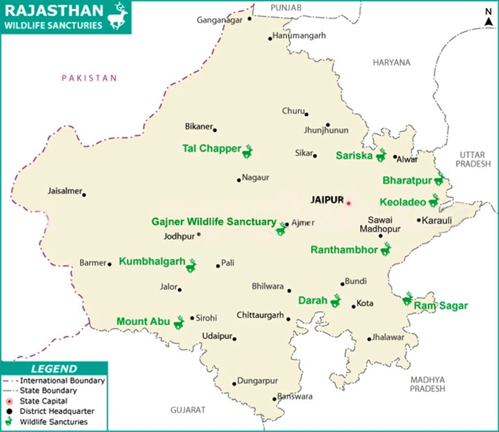
- Location and Geography:
- Sariska Tiger Reserve is located in Alwar district, Rajasthan, stretching across
881 square kilometres of diverse landscapes.
-
- The terrain includes scrub-thorn arid forests, dry deciduous forests, grasslands, and rocky hills.
- It forms a crucial part of the Northern Aravalli leopard and wildlife corridor. Situated within the Aravalli Range, the park’s elevation ranges from 300 to 722 meters, receiving an average annual rainfall of about 700 mm.
- Sariska is also rich in mineral resources like copper, although illegal marble mining continues to threaten its fragile ecosystem despite the Supreme Court ban.
- Flora:
- The forests of Sariska are dominated by the dhok tree, which covers a major portion of the reserve.
- Other important tree species include salar, kadaya, dhak, gol, ber, khair, bargad, arjun, gugal, and bamboo.
- The undergrowth features numerous shrubs such as kair, adusta, and jhar ber, creating a varied and rich plant ecosystem suited to the dry conditions of the region.
- Fauna:
- Apart from being home to the Bengal tiger, Sariska hosts a wide variety of wildlife.
- Key mammal species include the Indian leopard, sloth bear, jungle cat, caracal, striped hyena, golden jackal, chital, sambar deer, nilgai, wild boar, honey badger, small Indian civet, mongoose species, Rhesus macaque, and Northern plains grey langur.
- Birdlife is equally rich, with species like the Indian peafowl, grey francolin, white-throated kingfisher, bush quail, sandgrouse, treepie, golden-backed woodpecker, crested serpent eagle, and the Indian eagle-owl.
- After losing its entire tiger population by 2005, Sariska became the first reserve in the world to successfully relocate tigers, starting in 2008. As of 2020, the reserve hosts around 20 tigers, marking a significant conservation success story.
Cholistan Desert
Why in news?
a. Recently, the Government of Pakistan decided to halt its ambitious canals project
aimed at extending irrigation networks into the Cholistan Desert.
About Cholistan Desert:
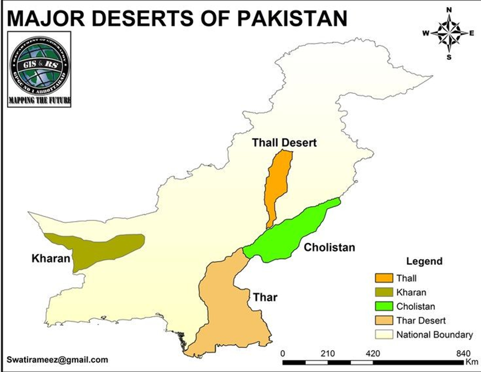
- Location and Background:
- The Cholistan Desert lies in the southern part of Punjab province, Pakistan, bordering the Thar Desert of India.
- It spans approximately 26,300 square kilometres and is characterised by extreme aridity, sand dunes, and sparse vegetation.
- The region relies heavily on traditional water sources like tobas (natural ponds) and rainwater harvesting for survival.
- Given its harsh conditions, government initiatives have long focused on improving water access and boosting agriculture through canal networks sourced from the Indus River system.
- The Cholistan Canal Project:
- The Cholistan Canal Project was an ambitious plan by the Government of Pakistan to construct a network of canals diverting water from the Indus River system to the Cholistan Desert in southern Punjab.
-
- The project's main goal was to convert arid desert land into fertile agricultural fields, thereby supporting food security, economic development, and population resettlement in one of the harshest regions of Pakistan.
- Reason Behind the Halt:
- Despite its economic promises, the project faced strong opposition from Sindh province, the lower riparian region of the Indus River.
- Sindh protesters and political leaders argued that the new canals would divert precious Indus water upstream, severely reducing water availability for agriculture, drinking, and industry in Sindh, which is already grappling with chronic water shortages.
- They warned that this would violate the spirit of the 1991 Indus Water Accord, which governs the equitable distribution of river water between provinces.
- Concerns also arose over the ecological impact of further water extraction from the Indus, which could accelerate desertification, reduce riverine ecosystems, and threaten the livelihoods of millions who depend on consistent water flows in Sindh.
Sandy Cay
Why in news?
a. The Philippines has strongly criticised China's recent actions around Sandy Cay in the South China Sea, labelling them as "desperate and cheap stunts."
About Sandy Cay:
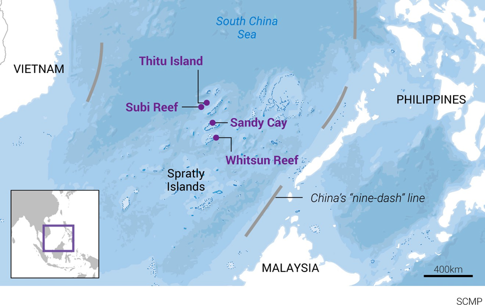
- Location:
- Sandy Cay is a group of small sandbars located approximately four nautical miles west of Pag-asa Island (part of the Kalayaan Island Group), within the Philippines’ Exclusive Economic Zone (EEZ) in the West Philippine Sea (South China Sea).
- It lies strategically near Philippine-occupied territory and is a critical feature in ongoing territorial assertions in the region.
- Territorial Disputes:
- The Philippines firmly considers Sandy Cay as part of its sovereign territory.
- Recently, tensions flared when Chinese personnel reportedly raised a Chinese flag and conducted inspection activities on the sandbar, actions that Philippines condemned as "desperate and cheap stunts" aimed at misleading international opinion and bolstering illegitimate claims.
- The Speaker of the Philippine House of Representatives emphasised that Sandy Cay falls well within Philippine jurisdiction, citing the 2016 ruling of the Permanent Court of Arbitration (PCA) in The Hague, which invalidated China's sweeping claims over the South China Sea, including areas surrounding Sandy Cay.
- South China Sea Context:
-
- The South China Sea is a hotbed of overlapping territorial claims involving China, the Philippines, Vietnam, Malaysia, Brunei, and Taiwan.
- China’s "nine-dash line" claims nearly the entire sea, despite the PCA’s ruling
rejecting its historical rights argument.
-
- The sea holds vast untapped reserves of oil and natural gas, making it economically and strategically vital.
- The Philippines' National Security Council (NSC) and National Task Force-West Philippine Sea reaffirmed Philippine sovereignty by launching a coordinated maritime operation involving the Navy, Coast Guard, and Police-Maritime Group around Sandy Cay and nearby Pag-asa Cays.
- Officials urged China to cease provocative actions and respect international law to prevent further escalation in the region, where tensions have increasingly strained Philippines-China relations.
Saraswati River
Why in news?
a. Saraswati Board plans to divert Sutlej River water into the Saraswati’s believed course, collaborating with Haryana Space Centre for mapping.
About Saraswati River:
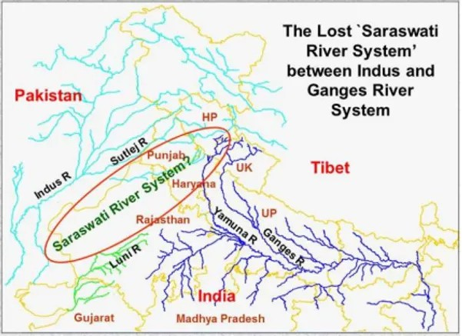
- Location:
- The Saraswati River is believed to have flowed through parts of modern-day Haryana, Rajasthan, and Gujarat before emptying into the Arabian Sea.
- Based on geological and satellite studies, the ancient river's course is associated with the present-day Ghaggar-Hakra river system.
- Traces of its paleo-channels have been found near Kurukshetra, Yamunanagar, and Sirsa in Haryana, and extending through Cholistan in Pakistan.
- The river is thought to have originated from the Himalayas, particularly from the
Bandarpunch glacier, and flowed parallel to the Yamuna and Sutlej rivers.
-
- Various efforts by the Indian government, including satellite imagery mapping by the Haryana Space Applications Centre (HARSAC), are underway to revive and trace its ancient course.
- Cultural and Religious Significance:
- The Saraswati River holds immense cultural and religious significance in
Hindu tradition.
-
- It is mentioned extensively in ancient Vedic texts, including the Rigveda, where it is described as a mighty and sacred river.
- Saraswati is often referred to as the "mother of all rivers" and the embodiment of knowledge, wisdom, and purity.
-
- According to Hindu beliefs, the Saraswati River was part of the holy Triveni Sangam at Prayagraj along with the Ganga and Yamuna.
- Even though it is no longer visible, it is believed to flow underground and spiritually confluences at the Sangam.
- The river is closely associated with important Vedic rituals and ancient civilisation sites of the Indus-Saraswati Civilisation, such as Rakhigarhi and Kalibangan, highlighting its role in the early cultural evolution of the Indian subcontinent.
Karangutta Hills
Why in news?
a. A Naxal cave hideout was discovered in the Karangutta Hills, revealing a strategic base used by insurgent groups.
About Karangutta Hills
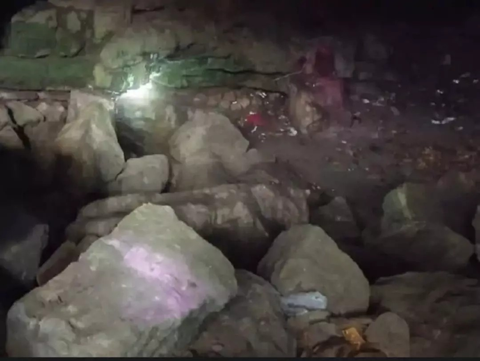
- Location:
- The Karangutta Hills are located in the central region of India, primarily spanning the states of Chhattisgarh and Madhya Pradesh.
- These hills are part of the Eastern Ghats and are characterised by dense forests, rough terrain, and remote mountainous areas.
- The region is sparsely populated, with limited access to infrastructure, making it a challenging area for both security forces and government administration.
- The Karangutta Hills are surrounded by various river valleys and wildlife sanctuaries, which further add to the area’s natural seclusion and difficult accessibility.
- Naxal Hideout:
- The Karangutta Hills have been identified as a strategic hideout for Naxalites
(Maoist insurgents).
-
- Due to its dense forests and isolated terrain, the region offers natural cover for Naxal groups who have been involved in armed resistance against the Indian government, especially in states like Chhattisgarh, Madhya Pradesh, and Odisha.
-
- A recent operation led to the unearthing of a Naxal cave hideout in these hills, confirming its use as a safe base for planning attacks, storing supplies, and training militants.
- The discovery of such hideouts underscores the ongoing challenges in combating Naxalism in the Red Corridor.
- The Karangutta Hills, with their difficult terrain and seclusion, remain a key area of concern for security forces combating the insurgency.
|
Also Read |
|
| FREE NIOS Books | |


PLACES IN NEWS 10th MAY 2025

PLACES IN NEWS 9th MAY 2025

PLACES IN NEWS 8th MAY 2025
Karol Bagh Metro Pillar No. 112, Above Domino's, 22B, First Floor, New Delhi - 110060
Very Important Instruction For Any Issue, Student Must Produce His/Her Fee Receipt. Without Fee Receipt, It Will Not Be Possible To Track Your Details. If You Have Been Given Any Special Consideration, You Must Keep That In Writing And Produce In Case Of Conflict.
Copyright © 2024-2026 ENSURE IAS. All rights reserved.