- Courses
- GS Full Course 1 Year
- GS Full Course 2 Year
- GS Full Course 3 Year
- GS Full Course Till Selection
- Online Program
- GS Recorded Course
- NCERT (Recorded 500+ Hours)
- Polity Recorded Course
- Geography Recorded Course
- Economy Recorded Course
- AMAC Recorded Course
- Modern India, Post Independence & World History
- Environment Recoded Course
- Governance Recoded Course
- Science & Tech. Recoded Course
- International Relations and Internal Security Recorded Course
- Disaster Management Module Course
- Ethics Recoded Course
- Essay Recoded Course
- Current Affairs Recoded Course
- CSAT
- 5 LAYERED ARJUNA Mentorship
- Public Administration Optional
- ABOUT US
- OUR TOPPERS
- TEST SERIES
- FREE STUDY MATERIAL
- VIDEOS
- CONTACT US
PLACES IN NEWS 10th MAY 2025
PLACES IN NEWS 10th MAY 2025
10-05-2025

Hemis National Park
Why in news?
Hemis National Park in Ladakh hosts the world's highest snow leopard density, showcasing India’s critical role in species conservation.
About Hemis National Park:
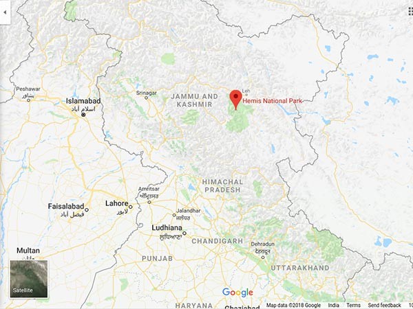
- Location and Geography:
- Hemis National Park, located in the eastern part of Ladakh, Union Territory of India, lies within the Trans-Himalayan region, nestled between the Indus River and the Zanskar range.
- Spanning approximately 4,400 sq. km, it is India’s largest national park and one of the highest-altitude protected areas in the world, ranging from 3,000 to over 6,000 meters.
-
- The park includes rugged valleys, high mountain passes, alpine meadows, and steep gorges.
- Its cold desert climate features sparse vegetation and extremely low precipitation, especially in winter.
- Flora and Fauna:
- Despite its harsh terrain, Hemis supports unique alpine and dry temperate vegetation, including juniper, wild rose, poplar, and birch at lower elevations.
- It is internationally celebrated for its rich biodiversity, especially as a stronghold of the endangered Snow Leopard (Panthera uncia), which finds ideal habitat and prey here.
- Other important fauna includes the Asiatic ibex, bharal (blue sheep), Ladakh urial, Himalayan marmot, and red fox, while avifauna includes golden eagle, lammergeier, and Himalayan griffon.
- Significance for Snow Leopard Conservation:
- Hemis National Park holds the world’s highest density of snow leopards, estimated at 8–10 per 100 sq. km, making it a flagship site for global conservation efforts.
- It plays a central role in India’s Project Snow Leopard, launched in 2009 to ensure landscape-level conservation across five Himalayan states.
- Internationally, Hemis is part of the Global Snow Leopard and Ecosystem Protection Program (GSLEP), a 12-country initiative led by Snow Leopard Range Countries, including India, supported by organisations like the UNDP, WWF, and Snow Leopard Trust.
- The park is a model for community-based ecotourism, involving local Ladakhi communities in conservation and reducing human-wildlife conflict, thus integrating livelihood and wildlife protection.
Gomti River
Why in news?
Once pristine, the Gomti River now faces severe pollution and encroachment, threatening its survival and Lucknow’s water security.
About Gomti River:
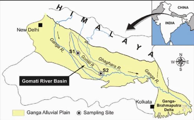
- Origin and Course:
- The Gomti River, a tributary of the Ganges, originates from Gomat Taal near
Madho Tanda in Pilibhit, Uttar Pradesh.
-
- Revered in Hindu mythology as Rishi Vashishtha’s daughter, it flows 940 km through the Gangetic plains, passing major towns like Lakhimpur Kheri, Lucknow, Sultanpur, and Jaunpur.
- It receives tributaries such as the Gaihaaee, Sai, Sarayan, and Kathina, and enters Lucknow after 190 km, supplying water to the city before meeting the Ganges near Markandey Mahadeo temple.
- Pollution and Encroachment:
- The Gomti faces acute pollution due to untreated sewage, industrial effluents from sugar mills and distilleries, and solid waste dumped into its tributaries and drains—especially in urban centers like Lucknow.
- Of the 40 natural drains in Lucknow, 23 major ones now pour sewage instead of surplus rainwater.
- The high embankments constructed after the 1970s floods altered the natural floodplain and disrupted groundwater recharge.
- Additionally, unregulated urban expansion on the floodplain, like in Gomti Nagar—has reduced the river’s width and worsened its ecological stress.
-
- Projects such as the Bharwara Sewage Treatment Plant (Asia's largest, inaugurated in 2008) have underperformed, with only 10% capacity utilisation reported by 2014.
- Projects such as the Bharwara Sewage Treatment Plant (Asia's largest, inaugurated in 2008) have underperformed, with only 10% capacity utilisation reported by 2014.
- Rejuvenation Measures:
- Several initiatives have aimed to revive the river. The Gomti Riverfront Development Project, inspired by the Sabarmati model, was launched around 2015.
- However, it faced criticism from IIT Roorkee and environmentalists for increasing flood risks and disrupting the natural flow.
- The Central government’s Namami Gange programme and state-level projects have supported sewage treatment, mechanical dredging, and ecological restoration.
Vadakkumnathan Temple
Why in news?
Thrissur Pooram, Kerala’s grand temple festival, begins at Vadakkumnathan Temple. It showcases vibrant processions, percussion, and cultural heritage.
About Vadakkumnathan Temple:
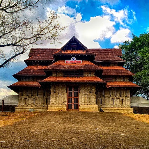
- Location and Establishment
- The Vadakkumnathan Temple is an ancient Hindu temple dedicated to Lord Shiva, located in Thrissur city, Kerala.
- It is a classical example of Kerala temple architecture, featuring monumental towers on four sides and an intricately designed koothambalam (temple theatre hall).
- The temple is believed to be the first of the 108 Shiva temples established by Parashurama, the sixth avatar of Vishnu, and is referred to in scriptures as Shrimad-Dakshina Kailasam ("Mount Kailash of the South").
- According to legend, Parashurama consecrated the lingam of Shiva at a place known as Sri Moola Sthana, later shifted to the temple’s present sanctum with royal patronage and ritual sanctity.
- The temple is notable for its mural paintings, particularly those illustrating scenes from the Mahabharata, and wooden carvings in the shrines and the kuttambalam.
-
- Recognising its historical and architectural value, the temple has been declared a National Monument under the AMASR Act and was recommended by the Archaeological Survey of India in 2012 for inclusion in the UNESCO World Heritage Sites list.
- Recognising its historical and architectural value, the temple has been declared a National Monument under the AMASR Act and was recommended by the Archaeological Survey of India in 2012 for inclusion in the UNESCO World Heritage Sites list.
- Cultural Significance
- The Vadakkumnathan Temple is the spiritual and cultural nucleus of the
Thrissur Pooram, Kerala’s most vibrant and iconic temple festival.
-
- Held annually in the Thekkinkadu Maidan that surrounds the temple, the festival showcases elephant processions, traditional percussion ensembles like Panchavadyam, and a grand fireworks display.
- Thrissur Pooram not only exemplifies Kerala’s rich temple culture but also reinforces the temple’s role as a centre of communal harmony and artistic expression.
Taklamakan Desert
Why in news?
China employs 600,000 workers to green the Taklamakan Desert, transforming an area the size of Germany to fight desertification.
About Taklamakan Desert:
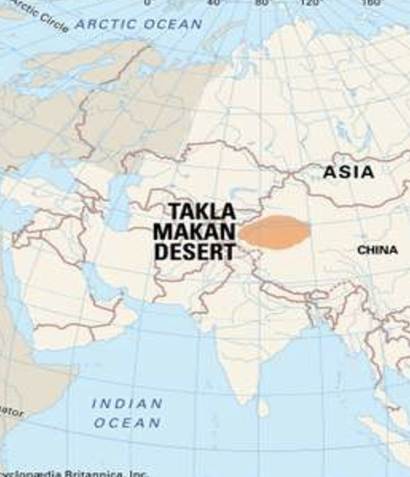
- Location and Geography:
- The Taklamakan Desert is one of the largest deserts in the world, located in the
Uyghur Autonomous Region of Xinjiang, in northwest China.
-
- Spanning an area of about 337,000 square kilometres, it lies between the Tian Shan mountain range to the north and the Karakoram range to the south.
- The desert is characterised by its vast stretches of sand dunes, salt flats, and arid landscapes, with some dunes rising over 300 meters.
- Known for its extreme temperatures, the Taklamakan experiences scorching summers and frigid winters. The desert is a critical component of the larger Central Asian arid zone.
- Expansion of Desertification
- Over the past few decades, the Taklamakan Desert has been expanding due to the accelerating process of desertification.
- This phenomenon is driven by a combination of climate change, overgrazing, and unsustainable agricultural practices.
-
- As the desert grows, it encroaches on nearby agricultural lands, leading to the displacement of local communities, loss of biodiversity, and increased frequency of sandstorms, which affect not only local ecosystems but also far-reaching regions like Beijing.
- The advancing desert has exacerbated the ecological degradation of the Gobi Desert and surrounding areas, making it a significant environmental challenge.
- Greening Efforts:
- China has made substantial strides in combating desertification and reversing the expansion of the Taklamakan Desert.
- The key initiative is the Three-North Shelterbelt Forest Program (TSFP), launched in 1978 and scheduled for completion by 2050.
- As part of this initiative, China has created a massive 3,046 km sand-blocking green belt around the desert, which serves as a protective barrier to stop desert encroachment.
- The program has led to the reforestation of over 32 million hectares of land and the planting of millions of trees, improving soil stability, increasing biodiversity, and enhancing carbon sequestration to mitigate climate change.
- The green belt has not only reduced the frequency of sandstorms but also contributed to improving the ecological conditions of the surrounding areas.
- With continued investment and community involvement, China aims to expand its afforestation efforts, positioning itself as a global leader in sustainable development and ecological restoration.
- These efforts mark a significant step towards achieving a greener, more climate-resilient future for the Taklamakan Desert and beyond.
|
Also Read |
|
| Public Administration Optional | |
| UPSC Monthly Magazine | Question Answer Practice For UPSC |

PLACES IN NEWS 10th MAY 2025

PLACES IN NEWS 9th MAY 2025

PLACES IN NEWS 8th MAY 2025
Karol Bagh Metro Pillar No. 112, Above Domino's, 22B, First Floor, New Delhi - 110060
Very Important Instruction For Any Issue, Student Must Produce His/Her Fee Receipt. Without Fee Receipt, It Will Not Be Possible To Track Your Details. If You Have Been Given Any Special Consideration, You Must Keep That In Writing And Produce In Case Of Conflict.
Copyright © 2024-2026 ENSURE IAS. All rights reserved.