Nicobar Islands
Why in the News?
- The Union government has sought a “factual report” from the Andaman and Nicobar Islands administration following a complaint by the Tribal Council of Little and Great Nicobar that forest rights were not settled before diverting 13,000 hectares for the ₹81,000-crore Great Nicobar Island project (2022).
- The Tribal Council alleged that its consent was obtained under pressure and later withdrawn, contradicting the administration’s certification that the Forest Rights Act (2006) process was completed.
About Nicobar Islands
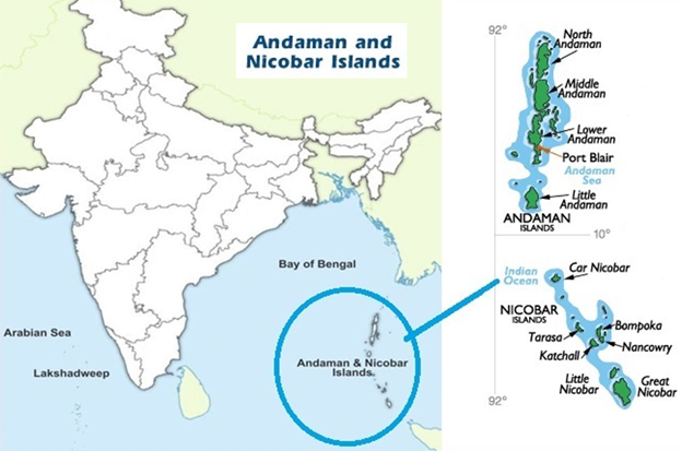
- The Nicobar Islands form the southern group of the Andaman & Nicobar Islands, separated from the Andamans by the Ten Degree Channel.
- They consist of 22 islands, of which 12 are inhabited; the largest is Great Nicobar Island.
- Great Nicobar is strategically important, located near the Malacca Strait, one of the world’s busiest shipping routes.
- The islands are home to indigenous tribes, mainly the Nicobarese (a Scheduled Tribe) and the Shompens (a Particularly Vulnerable Tribal Group – PVTG).
- The region is ecologically rich, with tropical rainforests, mangroves, and coral reefs, and is part of the Indo-Burma Biodiversity Hotspot.
- The Great Nicobar Biosphere Reserve (UNESCO-recognized) protects rare flora and fauna, including saltwater crocodiles, leatherback turtles, and endemic bird species.
- The area is seismically active—the 2004 Indian Ocean tsunami caused massive destruction and loss of life in Nicobar.
- Administration: The islands fall under the Union Territory of Andaman and Nicobar Islands, governed by an appointed Lieutenant Governor.
- The Protection of Aboriginal Tribes Regulation, 1956 restricts outsider access and protects the rights of indigenous communities.
Siachen
Why in the News?
- On 9 September 2025, three Army personnel (including two Agniveers) lost their lives when an avalanche struck a base camp in the Siachen sector of Ladakh at an altitude of around 12,000 feet.
- Despite rescue operations, the soldiers could not be saved, highlighting the extreme risks of avalanches and weather conditions faced by troops stationed in the region.
- The Indian Army’s Fire and Fury Corps paid tribute, calling it a supreme sacrifice in the world’s highest battlefield.
About Siachen Glacier
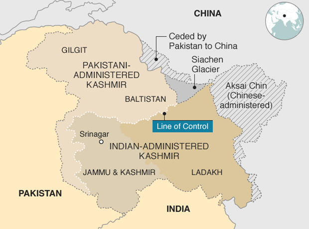
- Siachen Glacier is located in the eastern Karakoram range in the Himalayas, at an altitude of about 18,000–22,000 feet, making it the highest battlefield in the world.
- It stretches about 76 km in length, making it the second-longest glacier outside the polar regions.
- The glacier lies between the Saltoro Ridge (west) and the Karakoram Range (east), strategically important for India as it borders Pakistan and China.
- India controls the majority of the glacier since Operation Meghdoot (1984), when the Indian Army preemptively occupied key positions before Pakistan.
- Extreme conditions: Temperatures can drop to –50°C, with risks of frostbite, avalanches, and crevasses causing more casualties than combat.
- The glacier is strategically vital as it safeguards the Ladakh region and provides oversight of the Karakoram Pass and nearby territories.
- Logistics: Supplying and maintaining troops is extremely difficult; helicopters, air-drops, and specialized high-altitude gear are essential.
- Demilitarization talks have been held multiple times, but no agreement with Pakistan has been reached due to security and trust concerns.
- Siachen is also an important source of the Nubra River, which flows into the Shyok and later into the Indus.