- Courses
- GS Full Course 1 Year
- GS Full Course 2 Year
- GS Full Course 3 Year
- GS Full Course Till Selection
- Online Program
- GS Recorded Course
- NCERT (Recorded 500+ Hours)
- Polity Recorded Course
- Geography Recorded Course
- Economy Recorded Course
- AMAC Recorded Course
- Modern India, Post Independence & World History
- Environment Recoded Course
- Governance Recoded Course
- Science & Tech. Recoded Course
- International Relations and Internal Security Recorded Course
- Disaster Management Module Course
- Ethics Recoded Course
- Essay Recoded Course
- Current Affairs Recoded Course
- CSAT
- 5 LAYERED ARJUNA Mentorship
- Public Administration Optional
- ABOUT US
- OUR TOPPERS
- TEST SERIES
- FREE STUDY MATERIAL
- VIDEOS
- CONTACT US
PLACES IN NEWS 28th MARCH 2025
PLACES IN NEWS 28th MARCH 2025

Senkaku Islands
Why in news?
- Japan expressed deep concerns over a prolonged Chinese Coast Guard incursion near the disputed Senkaku Islands in the East China Sea, marking one of the longest territorial water violations in recent history.
About Senkaku Islands:
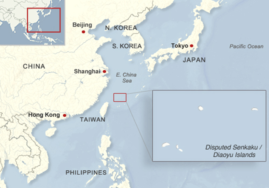
- Location and Geological Features
- The Senkaku Islands are an uninhabited group of islands in the East China Sea, approximately 90 nautical miles north of Japan’s Yaeyama Islands and 120 nautical miles northeast of Taiwan.
- They include Uotsuri Island, Kuba Island, Taisho Island, Kitakojima Island, Minamikojima Island, Tobise Island, Okinokitaiwa Island, and Okinominamiiwa Island.
- The total land area is 6.3 square kilometres, with Uotsuri Island being the largest at 3.6 square kilometres.
- Geologically, they consist of conglomerate sandstone, tuff, andesite, and andesitic lava, with coral outcroppings formed during the Holocene era.
- The surrounding region is highly volcanic, with fault lines affecting land formation.
- Geostrategic Importance
- The islands are situated along key shipping routes in the East China Sea, making them strategically important for global trade and maritime security.
- Their location provides a military advantage, allowing control over critical sea lanes and airspace.
- The surrounding waters are rich in marine biodiversity, supporting Japan’s fishing industry and serving as an essential food source.
- Potential reserves of oil and natural gas beneath the seabed further enhance their economic significance, drawing interest from multiple regional powers.
- Territorial Dispute and Administration
- The Senkaku Islands are administered by Japan as part of Ishigaki City, Okinawa Prefecture.
- Japan incorporated the islands into its territory in 1895, stating they were previously unclaimed.
- China and Taiwan contest Japan’s sovereignty, referring to them as the Diaoyu Islands and Diaoyutai Islands, respectively.
- China claims historical ownership, citing Ming Dynasty records, while Taiwan asserts rights based on its proximity.
- The dispute escalated after the 1970s, when potential energy resources were discovered in the surrounding waters.
- Japan has rejected China’s claims, maintaining effective control and deploying its Coast Guard to monitor incursions by Chinese vessels.
- The United States recognizes Japan’s administrative control but remains neutral on the sovereignty issue, supporting peaceful resolution under international law.
Bandipur Tiger Reserve
Why in news?
- Karnataka declined Kerala's request to increase state-owned night bus services through Bandipur Tiger Reserve, maintaining the existing limit of four buses per state to protect wildlife and preserve the status quo.
About Bandipur Tiger Reserve:
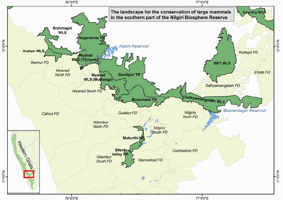
- Location and Geography
- Bandipur Tiger Reserve spans 868.63 sq. km in Chamarajanagar district, Karnataka, at the confluence of the Deccan Plateau and Western Ghats.
- The Kabini River marks its northern boundary; the Moyar River lies to the south, and the Nugu River flows through the park.
- Himavad Gopalaswamy Betta, the highest point, offers a panoramic view and houses a Hindu temple.
- The reserve experiences a tropical climate with distinct wet and dry seasons.
- Flora and Fauna
- Bandipur hosts dry and moist deciduous forests, with notable trees like teak, rosewood, sandalwood, and Indian laurel.
- It supports diverse wildlife, including Bengal tigers, Asian elephants, gaurs, dhole, sloth bears, and golden jackals.
- Over 200 bird species inhabit the park, such as the crested serpent eagle, Indian vulture, and changeable hawk-eagle.
- Reptiles like spectacled cobras, Indian pythons, and monitor lizards are commonly found.
- Conservation Status and Nilgiri Biosphere Reserve
- Bandipur was declared a tiger reserve in 1973 under Project Tiger and later included in the Nilgiri Biosphere Reserve (1986).
- The Nilgiri Biosphere Reserve is India’s first UNESCO-designated biosphere reserve, covering Western Ghats regions of Karnataka, Kerala, and Tamil Nadu.
- It shares boundaries with Mudumalai Tiger Reserve (Tamil Nadu), Wayanad Wildlife Sanctuary (Kerala), and Nagarhole National Park (Karnataka), forming a vast protected corridor for wildlife movement.
- The park faces threats from poaching, habitat fragmentation, and vehicular traffic, leading to measures like night traffic restrictions to reduce human-wildlife conflicts.
Lake Baikal
Why in news?
- Lake Baikal, the world's oldest and deepest lake, contains more freshwater than all the Great Lakes combined, supporting unique biodiversity.
About Lake Baikal:
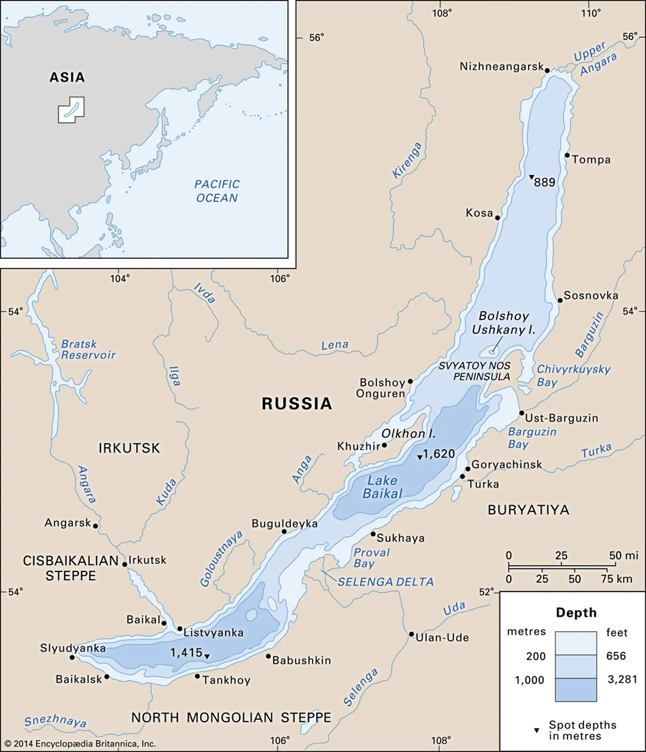
- Location and Origin
- Lake Baikal, located in southern Siberia, Russia, is the world’s deepest and oldest freshwater lake.
- It stretches approximately 636 km in length and 79 km in width, covering a total area of about 31,722 sq. km.
- The lake was formed due to a continental rift system that began developing nearly 25 to 30 million years ago, making it one of the few ancient lakes that still exist today.
- This active geological rift continues to widen, contributing to Baikal’s ever-changing landscape.
- Freshwater Availability Compared to the Great Lakes
- Baikal holds nearly 23,600 cubic kilometres of freshwater, which accounts for about 20% of the world's unfrozen freshwater reserves.
- This makes it the largest freshwater lake by volume, surpassing the combined water volume of North America's five Great Lakes—Superior, Michigan, Huron, Erie, and Ontario—which together contain approximately 22,700 cubic kilometres of water.
- Its extraordinary depth, reaching a maximum of 1,642 metres, allows it to store such a massive volume despite being smaller in surface area than the Great Lakes.
- Ecological Significance
- Often called the “Galapagos of Russia”, Lake Baikal is a UNESCO World Heritage Site and an ecological treasure trove.
- Due to its isolation and ancient origins, the lake harbours over 1,500–1,800 unique animal species, many of which are endemic.
- The most iconic of these is the Baikal seal (Nerpa), the only freshwater seal species in the world.
- The lake also supports more than 320 bird species and numerous plant species, with an incredibly diverse ecosystem that continues to be a major area of interest for evolutionary biologists.
- Additionally, its crystal-clear waters, sometimes offering visibility up to 40 metres, contribute to its pristine beauty and scientific significance.
- Recent Ecological Threats
- Pollution and Industrial Waste: Increased industrialisation and waste discharge from paper mills, along with untreated sewage from nearby towns, have led to rising levels of phosphates and nitrates, which cause algal blooms and disrupt the aquatic ecosystem.
- Climate Change: Rising temperatures have altered the lake's ice cover patterns, affecting the breeding cycles of endemic species like the Baikal Seal. Reduced ice cover also impacts the lake’s oxygen levels and overall biodiversity.
- Illegal Fishing and Poaching: Overfishing and poaching, particularly of the Baikal Sturgeon and endemic fish species, pose significant threats to the ecosystem.
- Tourism Impact: While tourism boosts the local economy, unregulated activities contribute to littering, habitat destruction, and increased water contamination.
- Hydroelectric Projects: Large-scale dam projects on rivers feeding Lake Baikal threaten to alter its water levels, affecting the natural balance of its ecosystem.
Kilauea volcano
Why in news?
- Hawaii’s Kilauea volcano, one of the world’s most active, erupts again, but officials confirm no immediate threat to nearby residents.
About Kilauea volcano:
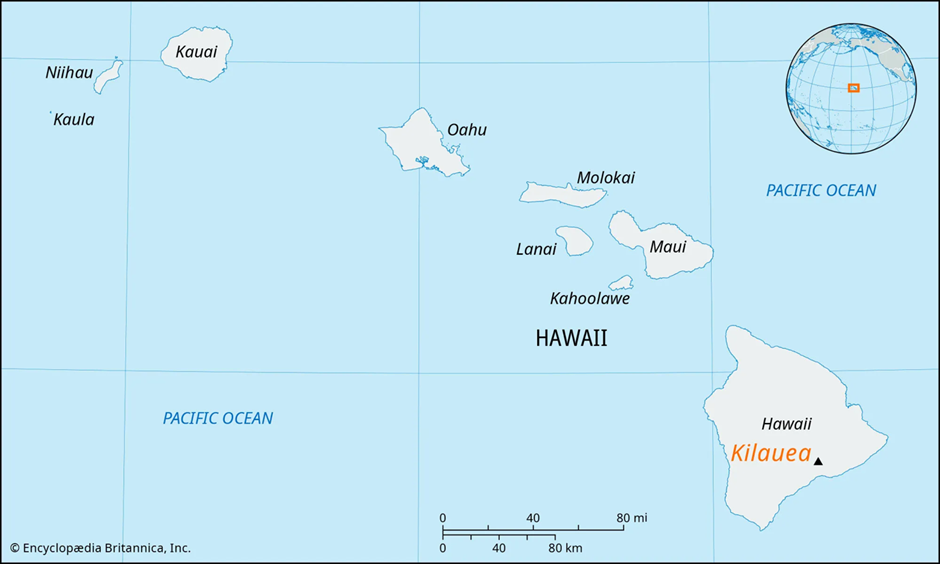
- Location and Geological Formation
- Kīlauea is an active shield volcano located on the southeastern side of the Big Island of Hawaii, within Hawai'i Volcanoes National Park.
- It is part of the Hawaiian–Emperor seamount chain, formed due to the movement of the Pacific tectonic plate over a stationary hotspot in the Earth's mantle.
- This hotspot continuously supplies magma, creating volcanic islands over millions of years.
- Formation of Hawaiian Volcanoes
- Hawaiian volcanoes, including Kīlauea, are shield volcanoes, characterised by broad, gently sloping profiles formed by highly fluid basaltic lava flows.
- Unlike stratovolcanoes, which produce explosive eruptions, shield volcanoes like Kīlauea typically experience effusive eruptions, where lava steadily flows out, gradually shaping the island.
- The Hawaiian island chain consists of five main volcanoes:
- Mauna Loa – The world’s largest active volcano.
- Mauna Kea – dormant, with the highest peak in Hawaii.
- Kīlauea – One of the most active volcanoes globally.
- Hualālai – Active but currently dormant.
- Kohala – Extinct.
- Impact of Kīlauea’s Volcanic Activity
Positive Impacts |
Negative Impacts |
Land Formation: Continuous lava flows expand the island, creating new land. |
Destruction of Property: Lava flows have destroyed homes, roads, and infrastructure. |
Fertile Soil: Volcanic ash enriches the soil, benefiting agriculture. |
Air Quality Issues: Emissions like sulphur dioxide cause “vog” (volcanic smog), affecting health. |
Tourism and Economy: The volcano attracts visitors, boosting Hawaii’s tourism industry. |
Displacement of Communities: Eruptions force residents to evacuate, leading to economic losses. |
Scientific Research: Provides insights into volcanology and Earth’s geological activity. |
Environmental Damage: Lava flows disrupt ecosystems and impact native wildlife. |
Niger
Why in news?
-
-
- General Abdourahamane Tchiani, who led Niger's 2023 coup, has been sworn in as president for a five-year term.
- General Abdourahamane Tchiani, who led Niger's 2023 coup, has been sworn in as president for a five-year term.
-
About Niger:
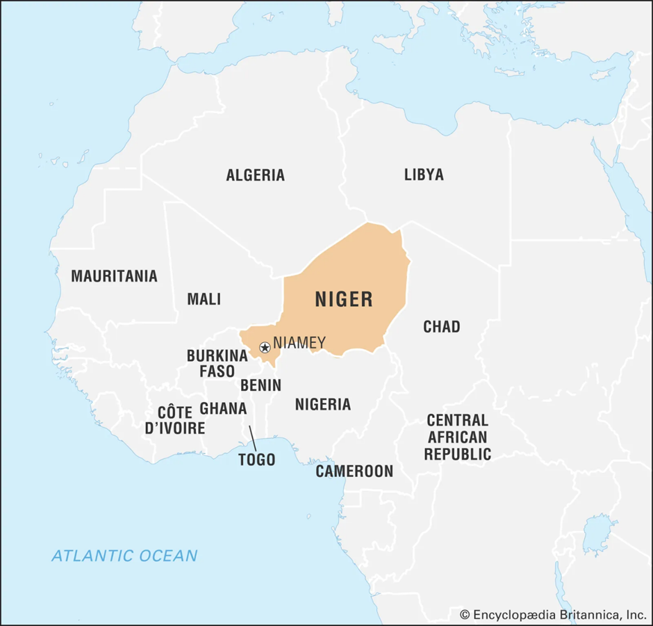
- 1. Location
- Niger is a landlocked country in West Africa, bordered by Algeria and Libya to the north, Chad to the east, Nigeria and Benin to the south, and Burkina Faso and Mali to the west.
- The country is dominated by the Sahara Desert in the north, while the southern regions have savannah landscapes that support agriculture.
- The Niger River, from which the country gets its name, flows through the southwest, providing a vital water source for the population.
2. Origin of Coups and Affected Regions
- Niger has experienced several coups since gaining independence from France in 1960.
- Military takeovers have often been triggered by political instability, economic challenges, and security threats.
- Some key coups in Niger’s history include:
- 1974 Coup: Led by Seyni Kountché, overthrowing President Hamani Diori due to economic mismanagement and food crises.
- 1996 Coup: Removed the first democratically elected president, Mahamane Ousmane.
- 1999 Coup: Resulted in a brief return to democracy.
- 2010 Coup: Deposed President Mamadou Tandja for attempting to extend his rule beyond constitutional limits.
- 2023 Coup: Led by Gen Abdourahamane Tchiani, citing security concerns and dissatisfaction with President Mohamed Bazoum’s governance.
- Regions most affected by coups and instability include:
- Tillabéri and Tahoua (West Niger): Frequent jihadist attacks from groups linked to ISIS and Al-Qaeda.
- Diffa (East Niger): Threatened by Boko Haram insurgency spilling over from Nigeria.
- Niamey (Capital): The political centre where coups and power struggles take place.
3. Recent Updates and Political Developments
In March 2025, Gen Tchiani was sworn in as the president for a five-year transitional period, replacing the country's constitution with a new charter. Key developments include:
- Dissolution of Political Parties: Tchiani banned all political organisations.
- Tension with ECOWAS: Niger, along with Mali and Burkina Faso, has withdrawn from the regional bloc, citing interference in domestic affairs.
- Shift in Foreign Policy: Niger cut ties with France and strengthened relations with Russia.
- Security Concerns: Jihadist groups remain active, with ongoing military operations.
- Prosecution of Former President Bazoum: He faces charges of high treason and remains in detention.
4. Other African Countries Facing Military Coups
- Mali (2020, 2021): Military-led interim government in power.
- Guinea (2021): President Alpha Condé was overthrown.
- Burkina Faso (2022): Two coups within a year, citing jihadist threats.
- Sudan (2021): The military dissolved the civilian government, leading to mass protests.
- Gabon (2023): The military deposed President Ali Bongo after election disputes.
|
UPSC CSE PYQs Q1. Consider the following statements :
|
|
Also Read |
|
UPSC Foundation Course |
|
| UPSC Monthly Magazine | CSAT Foundation Course |


World's First 'Black Hole Bomb' Created in a Lab (2025)

From Democracy to Emocracy: Understanding the Shift

PLACES IN NEWS 5th MAY 2025
Karol Bagh Metro Pillar No. 112, Above Domino's, 22B, First Floor, New Delhi - 110060
Copyright © 2024-2026 ENSURE IAS. All rights reserved.