- Courses
- GS Full Course 1 Year
- GS Full Course 2 Year
- GS Full Course 3 Year
- GS Full Course Till Selection
- Online Program
- GS Recorded Course
- NCERT (Recorded 500+ Hours)
- Polity Recorded Course
- Geography Recorded Course
- Economy Recorded Course
- AMAC Recorded Course
- Modern India, Post Independence & World History
- Environment Recoded Course
- Governance Recoded Course
- Science & Tech. Recoded Course
- International Relations and Internal Security Recorded Course
- Disaster Management Module Course
- Ethics Recoded Course
- Essay Recoded Course
- Current Affairs Recoded Course
- CSAT
- 5 LAYERED ARJUNA Mentorship
- Public Administration Optional
- ABOUT US
- OUR TOPPERS
- TEST SERIES
- FREE STUDY MATERIAL
- VIDEOS
- CONTACT US
PLACES IN NEWS 20th DECEMBER 2024
PLACES IN NEWS 20th DECEMBER 2024
20-12-2024
Hindon River
Why in news?
- The Hindon River has tragically transformed into a drain, carrying untreated industrial and domestic waste and epitomizing severe environmental degradation.
- Flowing through Western Uttar Pradesh, the river once supported agriculture and sustained communities, but unchecked industrial discharge, urban runoff, and lack of effective waste management have polluted its waters.
About Hindon River:
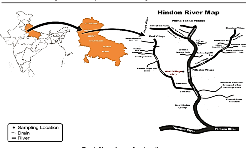
- The Hindon River is a rain-fed tributary of the Yamuna, originating in the Saharanpur district of Uttar Pradesh and flowing through the industrial belt of Western Uttar Pradesh before merging with the Yamuna.
- Spanning approximately 400 kilometres, the river holds historical and cultural significance, once serving as a vital resource for agriculture and drinking water.
-
Causes of Pollution:
- Industrial Discharge: Unregulated effluents from industries, including sugar mills, distilleries, paper mills, and textile units, directly enter the river without adequate treatment.
- Domestic Sewage: Urbanisation along the riverbanks has led to the unchecked release of untreated sewage and solid waste into the river.
- Agricultural Runoff: Excessive use of chemical fertilisers and pesticides contaminates the river through runoff during monsoon rains.
- Encroachment: Over-extraction of river water for irrigation and urban development has reduced its natural flow, exacerbating pollution levels.
- Inadequate Regulation: Poor enforcement of environmental laws and lack of efficient waste management systems worsen the situation.
-
Multidimensional Impact:
- Environmental: The river’s water quality has deteriorated significantly, with high levels of toxins, heavy metals, and biological contaminants threatening aquatic biodiversity.
- Health Risks: Communities relying on the river face severe health issues, including waterborne diseases, cancer, and respiratory problems caused by polluted air near the river.
- Agricultural Decline: Contaminated water used for irrigation reduces soil fertility and affects crop quality, impacting farmers’ livelihoods.
- Socio-Economic: Degradation of the Hindon disrupts traditional livelihoods, exacerbates poverty, and creates economic burdens for healthcare and water treatment.
- Cultural Loss: Once revered as a lifeline, the river now symbolises neglect, eroding its cultural and spiritual significance.
Kailash Mansarovar Yatra
Why in news?
- India and China have agreed to resume the Kailash Mansarovar Yatra for Indian pilgrims, a significant step amid years of strained ties.
- The decision followed a meeting in Beijing between National Security Advisor Ajit Doval and Chinese Foreign Minister Wang Yi, marking the first formal dialogue of Special Representatives in five years.
About Mount Kailash:
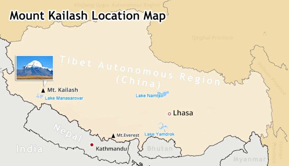
- Mount Kailash is a striking peak located in the remote Trans-Himalayan region of Tibet, standing at an elevation of 6,638 meters.
- It is part of the Gangdise Mountain range and is the source of several major rivers, including the Indus, Sutlej, Brahmaputra, and Karnali. Despite its grandeur, it remains unclimbed, as it is considered sacred.
- The mountain holds immense religious significance in Hinduism as the mythical abode of Lord Shiva and Goddess Parvati. Hindus revere it as a centre of spiritual power and consider circumambulation of the peak, or parikrama, a path to salvation.
- In Buddhism, Mount Kailash is associated with Demchok, a representation of supreme bliss, and is believed to be the axis mundi, or the centre of the universe. Buddhists perform circumambulation clockwise as an act of devotion.
- For the Jains, Mount Kailash is known as Ashtapada, the site where their first Tirthankara, Rishabhadeva, attained liberation. Followers of the Bon religion view it as the seat of spiritual power.
About Mansarovar:
- Mansarovar, located at an altitude of 4,590 meters, is a freshwater lake near Mount Kailash. It is one of the highest freshwater lakes in the world.
- According to Hindu mythology, Mansarovar was created by Lord Brahma and is considered a symbol of purity. Bathing in its waters and drinking it is believed to cleanse sins and grant spiritual merit.
- Buddhists revere Mansarovar as a sacred site representing enlightenment. The lake’s turquoise waters and tranquil surroundings enhance its spiritual allure.
About Kailash Mansarovar Yatra:
- The Kailash Mansarovar Yatra is an arduous pilgrimage undertaken by Hindus, Buddhists, Jains, and Bon followers. It involves a trek through challenging terrain to perform the parikrama of Mount Kailash and visit Mansarovar.
- The yatra is organised annually, typically from May to September, and requires participants to have physical fitness due to the high altitude and extreme weather.
- Pilgrims traverse the routes through India, Nepal, or China, with the Indian Ministry of External Affairs facilitating arrangements.
- Completing the 52-kilometre parikrama around Mount Kailash is considered highly meritorious. The trek includes the Dolma La Pass, the highest point at 5,645 meters, symbolising spiritual transformation.
- The yatra holds not only religious significance but also serves as a testament to endurance, devotion, and cultural unity across faiths.
Liberia
Why in news?
- The first India-Liberia Foreign Office Consultations (FOC) were held in Monrovia on December 17, co-chaired by Sevala Naik Mude, Additional Secretary, MEA, and Sara Beysolow Nyanti, Liberia's Minister of Foreign Affairs.
- Both sides reviewed bilateral relations, covering trade, investment, health, education, and energy development, while agreeing to deepen ties in digital infrastructure and development cooperation.
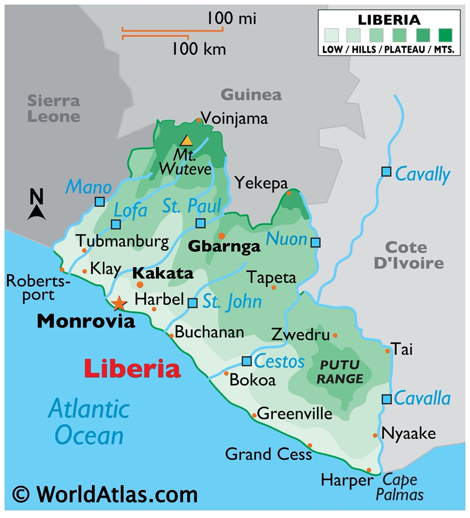
About Liberia:
-
geography
- Liberia is located on the west coast of Africa and is bordered by Sierra Leone to the northwest, Guinea to the north, Côte d’Ivoire to the east, and the Atlantic Ocean to the south and west.
- The country spans approximately 111,369 square kilometres, with a tropical climate marked by a rainy season (May-October) and a dry season (November-April).
- It features coastal plains, rolling hills, and lush forests, with Mount Wuteve (1,447 meters) being its highest point.
-
Natural Resources
- The country is endowed with rich natural resources, including iron ore, gold, diamonds, timber, and rubber. Liberia is one of the world’s top exporters of natural rubber, which has historically played a vital role in its economy.
- Its extensive forest cover also supports significant biodiversity and contributes to its timber exports.
- Offshore oil exploration holds potential, though it remains underdeveloped. Liberia’s fertile soils and abundant rainfall make agriculture a cornerstone of its economy, with crops like palm oil and cocoa being key products.
-
International participation
- Liberia actively participates in international organisations such as the African Union (AU), the United Nations (UN), and the Economic Community of West African States (ECOWAS).
- As a member of the International Solar Alliance (ISA), Liberia is committed to advancing renewable energy initiatives.
- It has also benefitted from global partnerships, including debt relief under the Heavily Indebted Poor Countries (HIPC) initiative and development programs supported by India and China.
-
Regional conflicts
- The country has a history of regional conflicts, notably during its two civil wars (1989–1996 and 1999–2003), which devastated its infrastructure, economy, and population.
- The conflicts were marked by widespread human rights abuses and led to the displacement of millions.
- Key regions affected included Monrovia, Lofa County, Nimba County, and Grand Gedeh County, which experienced intense fighting and severe humanitarian crises. While Liberia has achieved significant post-war recovery and stability, occasional land disputes and tensions in resource-rich areas persist.
- Liberia’s geopolitical position in a volatile region emphasises the importance of maintaining peace and fostering regional cooperation. Its alignment with ECOWAS ensures collective security and economic collaboration.
- Despite challenges, Liberia’s wealth of natural resources, active international engagement, and strategic efforts to address regional issues present opportunities for sustainable growth and stability.
Kawal Tiger Reserve
Why in news?
- Efforts are underway to relocate three villages from the core area of Kawal Tiger Reserve (KTR) in Telangana’s erstwhile Adilabad district under 'Project Tiger.'
- This initiative aims to minimize human-wildlife conflict, enhance habitat for tigers, and ensure better conservation.
- The relocation includes offering compensation and alternative settlements to affected families to improve their quality of life while reducing environmental pressures on the reserve.
About Kawal Tiger Reserve (KTR):
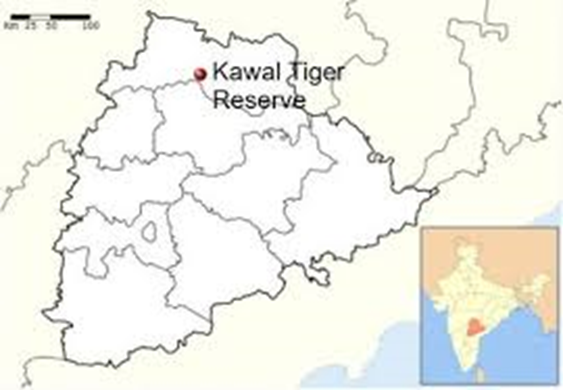
- Kawal Tiger Reserve (KTR) is located in the northern part of Telangana, spanning an area of approximately 2,015 square kilometres.
- It lies within the Deccan Plateau and features undulating terrain with streams and rivers, including the Kadam River, enriching its ecosystem. The reserve is part of the Godavari River basin, which supports its diverse habitats.
- The climate in KTR is predominantly tropical, with hot summers, mild winters, and monsoon rains.
- The reserve’s geography includes dense forests, dry deciduous woodlands, and open grasslands, providing a variety of ecosystems.
-
Flora
- KTR is known for its rich flora, which includes teak, bamboo, terminalia, and other dry deciduous species.
- The forest canopy supports a thriving undergrowth, essential for maintaining soil fertility and offering food and shelter to wildlife.
- Medicinal plants and endemic species add to its ecological significance.
-
Fauna
- The fauna of Kawal Tiger Reserve is equally impressive. It is home to tigers, which are the flagship species of the reserve, along with leopards, sloth bears, and wild dogs (dholes).
- Herbivores like spotted deer, sambar, and nilgai populate the grasslands, serving as prey for the reserve’s predators.
- The reserve also supports a variety of reptiles and amphibians, as well as birds like Indian rollers, grey hornbills, and peacocks, making it a haven for birdwatchers.
Deepor Beel
Why in news?
- Deepor Beel, Assam's sole Ramsar Site, faces severe environmental degradation due to the Belortol dumping ground located on NH-27.
- A study by the Pollution Control Board showed elevated biochemical oxygen demand and water pH, further threatening aquatic life.
- The daily dumping of 700 tonnes of waste exacerbates the issue, especially during the rainy season.
About Deepor Beel:
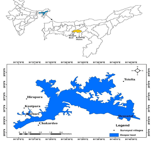
- Deepor Beel is a natural freshwater lake located on the southern bank of the Brahmaputra River in Kamrup Metropolitan District, Assam, India.
- The wetland spans over 900 hectares, making it the largest wetland in the region and an important ecological site.
- It lies close to the city of Guwahati and is connected to the Brahmaputra River through a system of channels, further enriching its water source.
- This wetland holds immense ecological importance, serving as a critical habitat for various species of wildlife, particularly aquatic birds.
- It is home to over 200 species of birds, including migratory species, making it a vital stopover for birds along the East Asia-Australasia Flyway.
- The wetland supports numerous species of fish, amphibians, and reptiles, contributing to the region's rich biodiversity.
- Deepor Beel's role in flood control is significant, as it helps to regulate water flow during the monsoon season, preventing flooding in surrounding areas. It acts as a natural stormwater buffer, absorbing excess water and releasing it gradually into the surrounding environment.
- In 2002, Deepor Beel was designated as a Ramsar Site, recognising its global importance as a wetland of international significance. This designation highlights its unique ecological value and the need for its protection.
- As a Ramsar Site, Deepor Beel is part of a global network of wetlands that are recognised for their biodiversity and ecosystem services, such as water purification, flood regulation, and carbon sequestration.
- The wetland’s ecological health is under threat due to urbanisation, pollution, and encroachment. Despite its protected status, pressures from nearby human settlements, including waste disposal, pose serious challenges to its preservation. Efforts to conserve Deepor Beel focus on sustainable management practices to protect its rich biodiversity and ecological functions.

| Also Read | |
| UPSC Prelims Result | UPSC Daily Current Affairs |
| UPSC Monthly Magazine | Previous Year Interview Questions |
| Free MCQs for UPSC Prelims | UPSC Test Series |
| ENSURE IAS NOTES | Our Booklist |

World's First 'Black Hole Bomb' Created in a Lab (2025)

From Democracy to Emocracy: Understanding the Shift

PLACES IN NEWS 5th MAY 2025
Karol Bagh Metro Pillar No. 112, Above Domino's, 22B, First Floor, New Delhi - 110060
Copyright © 2024-2026 ENSURE IAS. All rights reserved.