- Courses
- GS Full Course 1 Year
- GS Full Course 2 Year
- GS Full Course 3 Year
- GS Full Course Till Selection
- Online Program
- GS Recorded Course
- NCERT (Recorded 500+ Hours)
- Polity Recorded Course
- Geography Recorded Course
- Economy Recorded Course
- AMAC Recorded Course
- Modern India, Post Independence & World History
- Environment Recoded Course
- Governance Recoded Course
- Science & Tech. Recoded Course
- International Relations and Internal Security Recorded Course
- Disaster Management Module Course
- Ethics Recoded Course
- Essay Recoded Course
- Current Affairs Recoded Course
- CSAT
- 5 LAYERED ARJUNA Mentorship
- Public Administration Optional
- ABOUT US
- OUR TOPPERS
- TEST SERIES
- FREE STUDY MATERIAL
- VIDEOS
- CONTACT US
PLACES IN NEWS 12th FEBRUARY 2025
PLACES IN NEWS 12th FEBRUARY 2025

Darien Gap
Why in news?
Panama reported a sharp decline in irregular migration through the Darien Gap in early 2025, following stricter border controls, regional cooperation, and US policy changes reducing incentives for northward migration.
About Darien Gap:
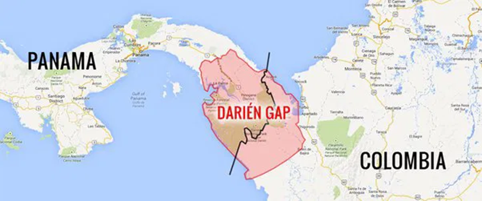
- Location:
- The Darien Gap is a dense and treacherous jungle between north-western Colombia and southern Panama.
- It forms a 160-km break in the Pan-American Highway, the only overland gap stretching from Alaska to Argentina.
- The region has thick rainforests, swamps, and rugged mountains, making it one of the most challenging terrains for human movement.
- Role in Illegal Immigration:
- Despite its difficult geography, the Darien Gap has become a major migration corridor for thousands of irregular migrants, primarily from Venezuela, Haiti, Cuba, and Africa, seeking to reach the United States and Canada.
- Migrants, often with the help of smugglers, undertake the dangerous journey through the jungle to bypass legal border crossings.
- The region’s inaccessibility makes it difficult for law enforcement to control illegal crossings, leading to unregulated migration, human trafficking, and organised crime.
- Humanitarian Crisis
- The Darien Gap is notorious for its harsh conditions and human suffering. Migrants endure severe hunger, dehydration, diseases, and violence from criminal gangs who exploit them for money, often through robbery, extortion, or sexual violence.
- Many perished due to exposure, drowning, or lack of medical assistance, while those who survive suffer long-term physical and psychological trauma. The crisis has overwhelmed humanitarian organisations and strained Panama’s resources in providing aid.
- Ecological Concerns
- Illegal migration and human trafficking routes have caused deforestation, habitat destruction, and pollution in the Darien rainforest.
- Increased foot traffic has disturbed fragile ecosystems, threatened native species, and accelerated environmental degradation.
- Conservationists warn that continued human encroachment could irreversibly damage one of the world's most biodiverse regions, affecting local wildlife and indigenous communities.
Donbas region
Why in news?
The Founding Chief Prosecutor for the UN Special Court for Sierra Leone advocates for establishing a Multinational Force and Observers for the Donbas Region (MFO-DR), composed of non-NATO nations like China, India, and Brazil, to mediate and ensure stability in the conflict-ridden Donbas region, fostering peace between Russia and Ukraine.
About Donbas region:
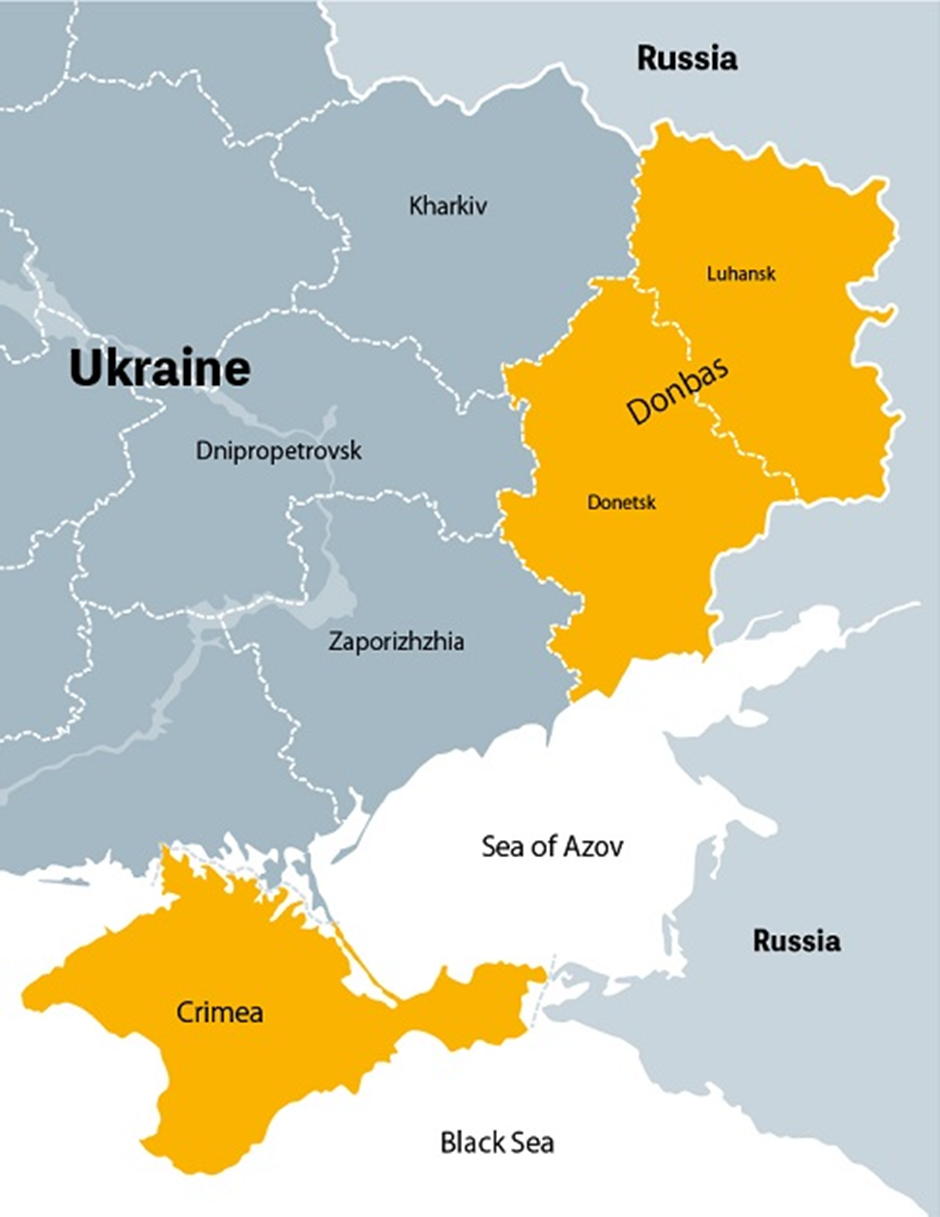
- Location:
- The Donbas region is located in eastern Ukraine, bordering Russia, and consists of two key oblasts (administrative divisions in the former Soviet Union region): Donetsk and Luhansk.
- It is an industrial heartland rich in coal, steel, and manufacturing, making it economically significant.
- The region's proximity to Russia and its historical ties to Soviet-era industries and Russian-speaking communities have made it a focal point of geopolitical tensions.
- Origin of Conflict:
- The conflict in Donbas traces back to 2014, following Russia’s annexation of Crimea.
- Pro-Russian separatists, backed by Moscow, declared independence in Donetsk and Luhansk, leading to clashes with Ukrainian forces.
- The war escalated into a prolonged armed insurgency, with Russia providing military, financial, and logistical support to separatists while Ukraine sought Western aid to reclaim sovereignty.
- In 2022, Russia launched a full-scale invasion of Ukraine, intensifying the battle for Donbas. The region became a key war zone, with cities like Mariupol, Severodonetsk, and Bakhmut witnessing some of the deadliest battles.
- Russia’s goal has been to secure complete control over Donbas, claiming to protect Russian-speaking populations, while Ukraine has resisted, viewing the conflict as a fight for national sovereignty.
- Other Key Regions in the War
Beyond Donbas, several other regions have played a critical role in the war:
- Crimea: Annexed by Russia in 2014, Crimea remains central to Moscow’s military strategy, serving as a base for naval operations in the Black Sea.
- Zaporizhzhia: Home to Europe’s largest nuclear power plant, Zaporizhzhia has been a contested battleground, raising fears of a nuclear catastrophe.
- Kherson: One of the first major cities captured by Russia in 2022, Kherson saw Ukrainian counteroffensives reclaiming lost territory.
- Kharkiv: Ukraine’s second-largest city, Kharkiv has faced relentless missile strikes, serving as a strategic front against Russian advances.
Jabalia refugee camp
Why in news?
- Residents of Jabalia refugee camp in northern Gaza hope for lasting peace as ceasefire negotiations between Israel and Hamas continue, following months of intense conflict and destruction.
- However, they fear renewed violence as they remain uncertain about the ceasefire's stability, given past escalations and ongoing humanitarian challenges in the war-torn region.
About Jabalia refugee camp:
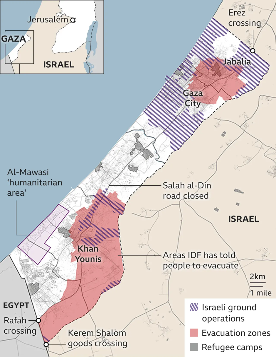
- The Jabalia Refugee Camp was established in 1948 by the United Nations Relief and Works Agency (UNRWA) to provide shelter for Palestinian refugees displaced after the 1948 Arab-Israeli War.
- It is located in the North Gaza Governorate, about 3 km north of Jabalia town and close to the Israeli border, and it is one of the most densely populated areas in Gaza, covering only 1.4 km².
- Historically, Jabalia has been a focal point of Palestinian resistance. The First Intifada in 1987 began in the camp, making it a symbol of defiance against Israeli occupation.
- It has also been identified as a stronghold of Hamas, leading to frequent Israeli military operations. The camp has been a target during multiple conflicts, including in 2014, 2023, and 2024, suffering significant destruction and civilian casualties.
- In the most recent conflict between 2023 and 2024, Jabalia was severely impacted. In October 2023, major Israeli airstrikes resulted in the deaths of at least 50 Palestinians, with over 400 casualties reported.
- By February 2024, Israeli forces withdrew from the camp, but the area was left in ruins, with over 10 km of tunnels destroyed. The devastation continued in May 2024, when nearly 70% of the camp was reduced to rubble following relentless bombardment and military operations.
- The humanitarian crisis worsened, and in June 2024, Palestinian authorities officially declared the camp a disaster area.
Other Refugee Camps in Gaza:
- Bureij Refugee Camp:
- Located in central Gaza.
- Targeted during Israeli airstrikes in 2023, leading to high civilian casualties.
- Faces severe humanitarian crises, including food and medical shortages.
- Khan Younis Refugee Camp:
- The largest city in southern Gaza, a major battleground in the 2023-2024 war.
- Witnessed mass displacement as civilians fled north and central Gaza.
- Israel accused Hamas of using it as a militant stronghold, leading to heavy bombardment.
- Maghazi Refugee Camp:
- A smaller camp in central Gaza, which was also heavily bombed in December 2023.
- Over 70 people were killed in a single airstrike on a residential area.
- Nuseirat Refugee Camp:
- Located near Deir al-Balah in central Gaza.
- Suffered multiple Israeli airstrikes, resulting in widespread civilian casualties.
- Home to thousands of displaced families due to fighting in northern Gaza.
- Rafah Refugee Camp:
- Southernmost refugee camp, bordering Egypt.
- Became Gaza’s last refuge for civilians fleeing the war.
- Site of Israeli ground operations in 2024, with thousands displaced and border crossings affected.
Gangotri National Park
Why in news?
Rare snow leopards in Gangotri National Park, Uttarakhand, face threats from feral and domestic dogs, which compete for prey, spread diseases, and disrupt the fragile Himalayan ecosystem, endangering conservation efforts.
About Gangotri National Park:
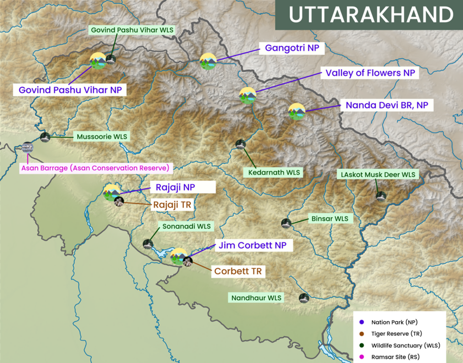
- Location and Geography:
- Gangotri National Park is located in the Uttarkashi district of Uttarakhand, covering an area of 2,390 km², making it one of the largest national parks in India.
- The park is situated in the upper catchment area of the Bhagirathi River, a major tributary of the Ganga River, and lies at an altitude ranging from 1,800 m to over 7,000 m.
- It encompasses glacial landscapes, alpine meadows, and dense coniferous forests, including the Gangotri Glacier, which is the origin of the Ganga River.
- The park is surrounded by high-altitude peaks, such as Chaukhamba, Gaumukh, and Shivling, making it ecologically and hydrologically significant.
- Flora and Fauna:
- Gangotri National Park exhibits a diverse range of vegetation zones, from temperate coniferous forests to alpine scrub and meadows.
- The dominant tree species include chir pine, deodar, fir, spruce, and rhododendron, which support a rich variety of wildlife.
- The park is home to rare and endangered species, including the snow leopard, which serves as a flagship species for conservation.
- Other key faunal species include the Himalayan black bear, musk deer, bharal (blue sheep), Himalayan tahr, and serow.
- The park also harbours a variety of bird species, such as the Himalayan monal (state bird of Uttarakhand), koklass pheasant, and golden eagle.
- The fragile ecosystem of Gangotri National Park faces threats from climate change, habitat loss, and increasing human-wildlife conflicts, including predation by feral dogs.
- Conservation efforts focus on sustainable ecotourism, habitat restoration, and protection of flagship species like the snow leopard to maintain ecological balance in the region.
About Snow Leopard
- Distribution & Habitat:
- The snow leopard is native to the high-altitude mountain ranges of Central and South Asia, spanning India, Nepal, Bhutan, China, Mongolia, Russia, and Pakistan.
- In India, it is found in the Himalayan and trans-Himalayan regions, including Ladakh, Himachal Pradesh, Uttarakhand, Sikkim, and Arunachal Pradesh.
- It inhabits steep, rugged terrains at altitudes between 3,000 and 5,400 meters, preferring rocky outcrops and alpine meadows.
- In Gangotri National Park, snow leopards thrive in cold deserts and alpine forests, preying on species like the bharal (blue sheep), Himalayan tahr, and musk deer, making them apex predators in the fragile Himalayan ecosystem.
- Ecological Role & Adaptations:
- Snow leopards play a crucial role in maintaining ecosystem balance by regulating herbivore populations, thus preventing overgrazing of alpine vegetation.
- They have unique adaptations, including thick fur, a long bushy tail for warmth and balance, and large nasal cavities to breathe in thin mountain air.
- Their powerful hind limbs enable them to leap up to 15 meters, making them highly agile in rocky terrains. They are also solitary and elusive, using camouflage to blend into their surroundings.
- Conservation Status & Threats:
- The IUCN Red List classifies the snow leopard as vulnerable, with an estimated global population of fewer than 7,000 individuals.
- In India, they are legally protected under Schedule I of the Wildlife Protection Act, 1972, and conservation efforts include the Project Snow Leopard (2009) initiative.
- Major threats include habitat loss due to climate change, retaliatory killings by herders, poaching for fur and bones, and increasing competition from feral and domestic dogs, which also spread diseases.
- Conservation strategies focus on community-based wildlife protection, eco-tourism, and transboundary conservation efforts to safeguard their fragile populations.
Nagavali River
Why in news?
Rampant sand mining in the Nagavali River threatens aquatic ecosystems, groundwater recharge, and riverbank stability, raising concerns over erosion, habitat destruction, and declining water availability.
About Nagavali River:
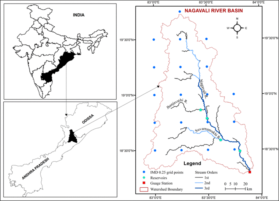
- Location and Origin:
- The Nagavali River, also known as Langulya, is one of the major rivers of Southern Odisha and Andhra Pradesh, situated between the Rushikulya and Godavari basins.
- It originates from a hill near Lakhbahal village of Kalahandi district, Odisha. The river flows through Rayagada district in Odisha before entering Srikakulam district in Andhra Pradesh, finally merging into the Bay of Bengal near Kallepalli village.
- The total length of the river is 256 km, of which 161 km lie in Odisha and the remaining in Andhra Pradesh. It has a catchment area of 9,510 sq. km, with 4,462 sq. km in Odisha and 5,048 sq. km in Andhra Pradesh.
- The major tributaries of Nagavali include Jhanjavati, Barha, Baldiya, Satnala, Sitagurha, Srikona, Gumudugedda, Vottigedda, Suvarnamukhi, Vonigedda, Relligedda, and Vegavati.
- Among these, the Jhanjavati River hosts the Jhanjavati Rubber Dam, India’s first and largest rubber dam, built in Vizianagaram district, Andhra Pradesh.
- Ecological and Economic Importance:
- The Nagavali River plays a crucial role in irrigation, drinking water supply, and hydroelectric power generation.
- Several irrigation projects, including Thotapalli Barrage, Narayanapuram Barrage, Madduvalasa Reservoir, and Vengalaraya Sagar, have been developed along the river to support agriculture.
- Additionally, pumped-storage hydropower projects with a capacity of 9,200 MW are planned in the river basin to meet the region’s renewable energy needs.
- The river also supports diverse flora and fauna, particularly in the upland hilly areas inhabited by tribal communities. The Hatipathar waterfalls near Rayagada are a notable ecological and tourism site along the river’s course.
- Sand Mining Issues and Environmental Concerns
- Rampant sand mining along the Nagavali River, especially near Srikakulam, Rayagada, and Kalahandi, poses serious environmental threats.
- Unregulated extraction has led to riverbank erosion, depletion of groundwater levels, and loss of aquatic biodiversity.
- The disruption of natural sediment flow has also weakened the structural integrity of irrigation barrages and bridges. Moreover, illegal sand mining, driven by construction demand, has worsened flood risks and habitat destruction in the region.
- Efforts to regulate sand mining, along with sustainable river basin management, are essential to protect the ecological balance of the Nagavali River while ensuring its continued support for agriculture and hydropower.
|
UPSC CSE PYQs Q1. Consider the following pairs:
Answer: Option D Q2. Consider the following rivers:
Which of the above rises from the Eastern Ghats? (2021)
Answer: Option B |
|
Also Read |
|
| FREE NIOS Books | |

Prime Minister's Inauguration of Projects in Amaravati, Andhra Pradesh
Government of Karnataka Notifies Hesaraghatta Grassland Conservation Reserve

Cancer Patients in UK to Receive Immunotherapy Drugs via Single Injection for Faster Treatment
Karol Bagh Metro Pillar No. 112, Above Domino's, 22B, First Floor, New Delhi - 110060
Copyright © 2024-2026 ENSURE IAS. All rights reserved.