Context
A major mega tsunami, with waves rising up to about 500 metres and counted among the tallest recorded, recently occurred in Alaska’s Tracy Arm Fjord after a huge landslide involving nearly 64 million cubic metres of rock fell into the water, displacing a large volume of water and triggering the event.
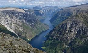
About Fjord
- Fjords are long, narrow and deep- sea inlets that extend far inland from the coast and are commonly found in countries such as Norway, Chile, New Zealand, Canada, Greenland and Alaska in the United States.
- These landforms are typically associated with mountainous coastal regions and are often surrounded by steep slopes and high mountains formed due to past glacial activity.
- They originated during the Ice Ages when large glaciers moved slowly and carved deep U-shaped valleys through strong erosional processes over long periods.
- After the glaciers melted, seawater filled these carved valleys, forming the present-day fjords.
- The deepest sections of fjords are usually located further inland, where the glacial erosion was strongest, while the mouth of the fjord that opens into the sea is generally comparatively shallow.
- In many cases, fjords are deeper than the adjacent sea they connect to, with the deepest reaching around 6300 feet (nearly 2000 metres).
- Some fjords also contain small rocky islands known as skerries and may even support coral reef formations in suitable conditions.
- A special feature found in some fjords is the presence of epishelf lakes, where fresh meltwater gets trapped above denser seawater under a floating ice shelf without mixing with it.
- A well-known example is Sognefjorden in Norway, which extends for more than 160 kilometres (about 100 miles) inland.