
Context
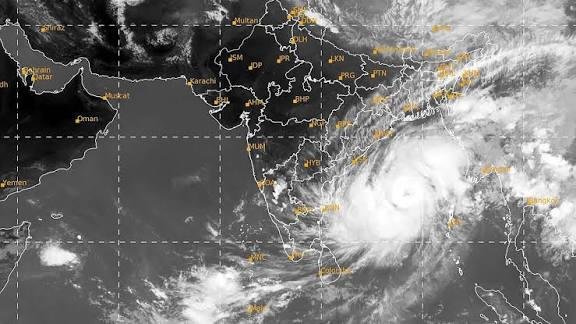
Cyclone Murasu developed over the Southwest Bay of Bengal and intensified from a deep depression into a Severe Cyclonic Storm. It was moving towards the Andhra Pradesh coast, with landfall expected near the Nellore region. The cyclone brought the possibility of heavy rainfall, strong winds, storm surges and coastal flooding.
What is a Tropical Cyclone?
- A tropical cyclone is a low-pressure system that develops over warm tropical oceans. It derives its energy mainly from warm ocean water and latent heat released during the condensation of water vapour.
- Conditions Required for Cyclone Formation
- High Sea Surface Temperature: Sea surface temperature should generally be above 26.5°C. Warm ocean water causes moist air to rise, creating a low-pressure area.
- Low Atmospheric Pressure and High Moisture: As warm air rises, the atmospheric pressure near the surface decreases. Winds from surrounding high-pressure areas move towards this low-pressure region. The rising water vapour cools and condenses to form clouds.
- Latent Heat Release: During condensation, water vapour changes from gas into liquid and releases latent heat. This heat warms the surrounding atmosphere and strengthens the low-pressure system.
- Coriolis Force:: Earth’s rotation produces the Coriolis force, which gives the developing system its rotating movement. Cyclones generally do not form within 5° latitude of the Equator because the Coriolis force is too weak there.
- Low Vertical Wind Shear: Vertical wind shear refers to changes in wind speed or direction with altitude. Strong vertical wind shear can disrupt the developing cyclone. Therefore, relatively low vertical wind shear is favourable for cyclone formation.
- Structure of a Tropical Cyclone: A tropical cyclone has three major structural components:
- Eye: The central region of the cyclone, generally characterised by calm winds and relatively clear skies.
- Eyewall: The region surrounding the eye, where the strongest winds and heaviest rainfall occur.
- Spiral Rain Bands: Curved bands of thunderstorms and rainfall extending outward from the centre.
- Direction of Rotation:
- Northern Hemisphere: Anti-clockwise.
- Southern Hemisphere: Clockwise.
About Cyclone Murasu
- It initially developed as a Deep Depression over the Southwest Bay of Bengal.
- Favourable oceanic and atmospheric conditions led to its intensification into a cyclonic storm and subsequently a severe cyclonic storm.
- Classification based on wind speed:
- Cyclonic Storm – 62–88 km/h
- Severe Cyclonic Storm – 89–117 km/h
- Expected Impact of Cyclone Murasu
- Strong winds: Wind speeds were expected to exceed 110 km/h, with gusts reaching around 120 km/h.
- Storm surge: Coastal areas could experience a rise in seawater levels of up to 2 metres.
- Heavy rainfall: Rainfall of approximately 115–200 mm was expected in coastal Andhra Pradesh.
- Coastal inundation: Seawater entering low-lying coastal areas.
- Flooding and infrastructure damage: Heavy rainfall and strong winds could damage infrastructure and disrupt normal activities.
- States on Alert: Andhra Pradesh, Tamil Nadu, Odisha and Telangana. The impact of a cyclone is not restricted to the landfall region. Moisture associated with the system can travel inland and cause rainfall and thunderstorms in distant regions.
Naming of Tropical Cyclones
- Cyclones are given names to make their identification and communication easier.
- Regional Naming Mechanism
- Coordinated through the WMO/UNESCAP Panel on Tropical Cyclones.
- India belongs to this regional cyclone-naming group.
- The India Meteorological Department (IMD), through its Regional Specialised Meteorological Centre (RSMC), New Delhi, is responsible for naming cyclones in this region.
- The region includes the Arabian Sea and the Bay of Bengal.
- A total of 13 countries participate in the naming process.
- Naming of Cyclone Murasu: The participating countries contributed names to a common list. These names are used sequentially as new cyclones develop. Murasu is a name given by India. It is a Tamil word meaning drum or war drum.
Important Terminology
| Term | Region |
| Cyclone | Indian Ocean region |
| Hurricane | Atlantic Ocean and northeastern Pacific |
| Typhoon | Western North Pacific, including the China Sea region |
Frequently Asked Questions (FAQs)
Q1. What is a tropical cyclone, and how does it form?
A tropical cyclone is a low-pressure system developing over warm tropical oceans. It draws energy from warm ocean water and latent heat released during condensation of water vapour.
Q2. What conditions are favourable for tropical cyclone formation?
Cyclone formation requires warm sea surface temperatures above 26.5°C, high moisture, low atmospheric pressure, sufficient Coriolis force and low vertical wind shear to support the development and rotation of the system.
Q3. What are the three major structural components of a tropical cyclone?
The three components are the eye, the relatively calm central region; the eyewall, where strongest winds and heaviest rainfall occur; and spiral rain bands, which contain curved bands of thunderstorms.
Q4. How are tropical cyclones named in the Indian Ocean region?
Cyclone naming is coordinated through the WMO/UNESCAP Panel on Tropical Cyclones. Thirteen countries contribute names to a common list, while IMD’s RSMC, New Delhi, assigns names sequentially.
Q5. What is the meaning and origin of the name Cyclone Murasu?
Murasu is a name contributed by India to the regional cyclone-naming list. It is a Tamil word meaning drum or war drum and was used for the cyclone.