
Context
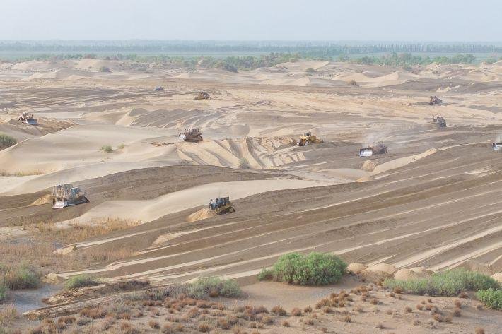
- China has developed vegetation and sand-control barriers around the Taklamakan Desert in Xinjiang to restrict shifting sand and protect oases, farmland, settlements and infrastructure.
- On 28 November 2024, China completed a 3,046-km sand-blocking green belt around the desert under the wider Three-North Shelterbelt Forest Programme.
- The focus has subsequently shifted towards strengthening and maintaining this protective ecological barrier.
About the Taklamakan Desert
- The Taklamakan Desert lies in Xinjiang in northwest China and occupies a large part of the Tarim Basin.
- It is bounded mainly by:
- Tian Shan Mountains to the north;
- Kunlun Mountains to the south;
- Pamir-related highlands towards the west.
- Covering roughly 337,600 sq km, it is China’s largest desert and one of the world’s largest sandy deserts.
- It is regarded as the world’s second-largest shifting-sand desert, with about 85% of its surface covered by mobile dunes.
- The Tarim River and mountain-fed streams support important oases along parts of its margins.
Why Is the Taklamakan Extremely Arid?
Three geographical factors explain its desert conditions:
- Continentality: Its great distance from oceans limits the arrival of moisture-bearing winds.
- Rain-shadow effect: Surrounding high mountain ranges block much of the incoming atmospheric moisture.
- Closed basin: The Tarim Basin has no outlet to the sea, encouraging high evaporation and accumulation of salts.
Why Are Shifting Sands a Problem?
Wind continuously transports sand across the desert margins.
This can result in:
- burial of agricultural land;
- damage to roads and railways;
- encroachment on settlements;
- pressure on oases;
- frequent dust and sand storms.
Thus, the environmental challenge is not the existence of the natural desert itself, but unstable sand spreading into economically and ecologically vulnerable areas.
China’s Desert-Control Strategy
The Taklamakan project forms part of China’s Three-North Shelterbelt Forest Programme, launched in 1978.
It uses a combination of:
- drought-resistant trees and shrubs;
- shelterbelts and windbreaks;
- grass-grid barriers that physically trap sand;
- restoration of vegetation around oases;
- desert-adapted species such as saxaul, red willow and Populus euphratica;
- photovoltaic projects combined with sand-control measures in some areas.
The programme is therefore better understood as integrated sand management, rather than simple afforestation.
How Does the Green Belt Work?
The basic mechanism is:
Vegetation/barriers → Lower wind speed → Reduced sand movement → Protection of land and infrastructure
- Windbreak effect: Vegetation reduces near-surface wind velocity.
- Sand trapping: Shrubs and physical barriers intercept wind-blown sediment.
- Root stabilisation: Plant roots help hold loose surface material.
- Oasis protection: Reduced dune movement protects farmland, settlements and transport corridors around the desert margin.
Why Is the Project Important?
- Large-scale desert management: It applies sand-control measures around almost the entire desert perimeter rather than through isolated local interventions.
- Protection of livelihoods: Reduced sand encroachment supports agriculture and settlements concentrated around desert oases.
- Infrastructure security: Roads, railways and energy infrastructure become less vulnerable to drifting dunes.
- Ecological adaptation: The project shows that dryland restoration requires a combination of vegetation, physical barriers and land management rather than tree planting alone.
Key Ecological Concern
A crucial distinction is:
Natural desert ≠ Desertified land
The Taklamakan is a naturally occurring desert created by climatic and geographical conditions. The objective should therefore be to control harmful sand encroachment, not transform the desert itself into forest.
Excessive plantation can also create problems because:
- water availability is extremely limited;
- unsuitable trees may have poor survival;
- intensive plantations can place pressure on groundwater.
Therefore, native drought-resistant shrubs, grasses and carefully designed shelterbelts are often more sustainable than dense afforestation.
Relevance for India
The Taklamakan experience offers useful lessons for India’s arid regions, particularly western Rajasthan.
- Dune stabilisation: Shelterbelts and vegetation barriers can reduce wind erosion and movement of sand.
- Native vegetation: Restoration should prioritise drought-resistant local grasses and shrubs suited to limited water availability.
- Integrated dryland management: Shelterbelts should be combined with grassland restoration, sustainable grazing and watershed management.
- Ecological suitability: Desert-control programmes should protect productive land without attempting to replace natural desert ecosystems.
The larger lesson is:
Control land degradation, not the natural desert.
FAQs
Q1. Where is the Taklamakan Desert located?
It lies mainly in the Tarim Basin of Xinjiang in northwest China.
Q2. Which mountains surround the Taklamakan Desert?
The Tian Shan Mountains lie to the north and the Kunlun Mountains to the south.
Q3. Why is the Taklamakan extremely dry?
Its continental location, surrounding mountains and closed-basin setting severely restrict moisture availability.
Q4. What is the purpose of China’s 3,046-km green belt?
It seeks to reduce shifting sand and protect oases, farmland, settlements and infrastructure.
Q5. Is China trying to convert the Taklamakan Desert into a forest?
No. The main objective is to stabilise vulnerable desert margins and control harmful sand encroachment.