Context
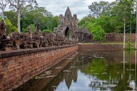
Archaeologists have discovered remains of a 12th-century water management system and structural features within the royal palace complex of Angkor Thom, providing new insights into the engineering and urban planning of the Khmer Empire.
About Angkor Thom
- Angkor Thom, meaning “Great City,” was the last and longest-lasting capital of the Khmer Empire in present-day Cambodia.
- It is located north of Angkor Wat, between the West Baray and East Baray reservoirs.
- The city was founded by Jayavarman VII after he defeated the Cham invaders and regained the Khmer capital in 1181.
- Angkor Thom was built mainly as a Mahayana Buddhist
- It also included elements of Hinduism and ancestor worship, reflecting the religious diversity of the Khmer Empire.
- The city remained the centre of Khmer rule during the later period of the empire and was abandoned by the 16th century.
- The city covers nearly 9 sq. km and includes monuments built during different periods of the Khmer Empire.
- Angkor Thom was planned as a square-shaped fortified city with walls about 8 metres high and 3 kilometres long on each side.
- A wide moat surrounds the city and forms part of its defensive system.
- The Bayon Temple, located at the centre of the city, is famous for its stone towers bearing giant carved faces.
- Other important structures include the Terrace of the Elephants, Terrace of the Leper King, Baphuon, and Phimeanakas.
- Angkor Thom is part of the Angkor Archaeological Park, which was designated a UNESCO World Heritage Site in 1992.