Summary of Tropical Cyclone Nivar
- What is a Tropical Cyclone?
- Tropical cyclones are large, low-pressure weather systems that form over warm ocean waters in tropical and subtropical regions.
- They are characterized by strong winds, heavy rainfall, and spiraling cloud systems.
- These storms derive energy from warm sea surfaces and lose strength after making landfall.
- Cyclone Nivar: Basic Details
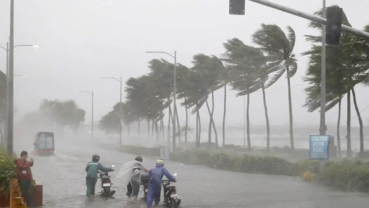
- Cyclone Nivar was a tropical cyclone that formed over the Bay of Bengal in November 2020.
- It made landfall between 24th and 25th November 2020.
- Affected Areas
- The cyclone severely impacted the following Indian states:
- Tamil Nadu
- Andhra Pradesh
- The cyclone severely impacted the following Indian states:
- Telangana
- Southern Karnataka
- Nature and Intensity of the Storm
- Cyclone Nivar was classified as a Very Severe Cyclonic Storm.
- It reached wind speeds of up to 120 km/h.
- These wind speeds are strong enough to cause structural damage, uproot trees, and disrupt communication and power lines.
- Impacts and Damages
- The cyclone led to:
- Heavy rainfall and flooding in coastal and inland areas.
- Strong winds that damaged infrastructure and agriculture.
- The cyclone led to:
- Coastal flooding due to storm surge and high tides.
- The estimated economic loss was around ₹5000 crores within just two days.
- Cyclone Nivar serves as a stark reminder of the destructive power of tropical cyclones, especially in coastal and densely populated regions.
- Timely forecasting and disaster preparedness are crucial to minimize the damage and loss of life from such extreme weather events.
Background of Tropical Cyclone Nivar
- Origin of the Term “Cyclone”
- The word “cyclone” is derived from the Greek word “cyclos,” meaning “coiling of a snake.”
- This name was given because the spinning wind pattern of a cyclone, especially as it approaches land, resembles a snake coiling or swirling.
- How a Cyclone Forms: Step-by-Step Process
- Warm Ocean Waters: The Starting Point
- Tropical oceans are filled with warm surface water.
- This warm water heats the air above it, making it rise upwards like a hot air balloon.
- Warm Ocean Waters: The Starting Point
- The rising air contains a lot of water vapor (moisture) collected from the ocean.
- Creation of Low-Pressure Zone
- As warm moist air rises, it leaves behind a vacuum or an area of low pressure near the ocean’s surface.
- Nature tries to balance this pressure difference, so air from nearby areas rushes in to fill this low-pressure area.
- Effect of Earth’s Rotation: The Coriolis Force
- The incoming air does not move straight into the low-pressure zone.
- Due to the Earth’s rotation, this air starts to spin or swirl.
- This spinning motion forms a rotating system of winds, creating the classic vortex or spiral shape of a cyclone.
- Why the Cyclone Looks Like a Coiled Snake
- The spiraling wind pattern, when viewed from above (e.g. satellite image), looks like the coils of a snake.
- This visual similarity is what gave rise to the name and also helps in understanding the rotating nature of cyclones.
- The formation of a tropical cyclone like Nivar is a natural chain reaction involving warm oceans, rising moist air, low pressure, and Earth’s rotation.
- This interaction creates a spinning storm system, with coiling winds that resemble the motion of a snake — both powerful and dangerous.
About Tropical Cyclone Nivar
- Origin of the Cyclone
- Cyclone Nivar originated due to a disturbance in the Inter-Tropical Convergence Zone (ITCZ).
- The ITCZ is a region near the equator where the northeast and southeast trade winds converge, often leading to the development of low-pressure systems and storms.
- Formation and Path
- A tropical depression (a low-pressure system with organized thunderstorms) formed over the Bay of Bengal.
- It made landfall near Puducherry, bringing strong winds and heavy rainfall.
- Progression After Initial Landfall
- After landfall, the system did not weaken immediately.
- It re-intensified into a Deep Depression over the Bay of Bengal.
- This led to a second landfall on the Andhra Pradesh coast.
- Impact
- The cyclone caused extensive damage to infrastructure, agriculture, and homes.
- There were also casualties reported during the cyclone’s course:
- 5 people died in Tamil Nadu.
- 8 people died in Andhra Pradesh.
Disaster Relief Response in India to Cyclone Nivar
- Impact on Urban and Rural Areas
- Chennai (Tamil Nadu) experienced severe urban flooding in several parts of the city.
- In Puducherry, the initial estimated damage to agriculture and other sectors was around ₹4 billion (US$54.2 million).
- Central Government Response
- The Government of India deployed six National Disaster Response Force (NDRF)
- NDRF personnel were tasked with:
- Evacuating people from vulnerable and low-lying areas.
- Providing search, rescue, and relief operations during the cyclone.
- State Government Measures (Tamil Nadu)
- The Tamil Nadu government took proactive steps to manage the disaster:
- Pre-positioned food and fuel stocks in cyclone-prone areas.
- Ensured availability of essential supplies to prevent panic and shortages during and after the storm.
- The Tamil Nadu government took proactive steps to manage the disaster:
Tropical Cyclone Nivar was a complex weather system that evolved rapidly and impacted multiple coastal states in India. Though loss of life occurred, timely intervention by both central and state governments helped in mitigating larger-scale devastation, demonstrating the importance of early warning systems and disaster preparedness.
Types and Formation of Tropical Cyclones
- Types of Cyclones: Cyclones are broadly classified into two major categories:
- Tropical Cyclones:
- Form over tropical or subtropical waters.
- Generally occur between the Tropic of Cancer and Tropic of Capricorn.
- Tropical Cyclones:
- Associated with warm ocean surfaces, strong winds, and heavy rainfall.
- Extra-Tropical Cyclones:
- Form in the mid-latitude or temperate zones, beyond the tropics.
- Generally associated with cold and warm air masses converging.
- Formation of a Tropical Cyclone:
- Step 1: Creation of Low-Pressure Area
- Warm ocean waters heat the air above, causing it to rise rapidly.
- This leads to the formation of a low-pressure zone at the ocean surface.
- Step 1: Creation of Low-Pressure Area
- The rising air contains moisture from the ocean.
- Step 2: Thunderstorm Formation
- The moist, rising air cools and condenses, leading to cloud formation and thunderstorms.
- Under the right atmospheric conditions, multiple thunderstorms cluster together and start rotating around the low-pressure center.
- Step 3: Strengthening Over Warm Waters
- As long as the system stays over the warm ocean, it continues to gather:
- Moisture
- Energy
- Rotational speed
- This process strengthens the cyclone further.
- As long as the system stays over the warm ocean, it continues to gather:
- Step 4: Landfall and Dissipation
- Once the cyclone reaches land (landfall):
- It loses its energy source (i.e., warm ocean water).
- The moisture supply is cut off, causing the storm to weaken.
- Eventually, it dissipates after causing potential destruction.
- Once the cyclone reaches land (landfall):
Characteristics of Tropical Cyclones
- Location:
- Occur in the tropical zones, primarily between 5° North and South latitude.
- Size and Structure:
- Tropical cyclones are large-scale weather systems, often spanning several hundred kilometers.
- Characterized by a central low-pressure core, surrounded by high-velocity winds and cloud bands.
- Wind Circulation Direction:
- In the Northern Hemisphere: Winds rotate anticlockwise (due to the Coriolis effect).
- In the Southern Hemisphere: Winds rotate clockwise.
Classifying Cyclones And Their Impact
Cyclones are classified by wind speed and damage capacity:
| Types of Cyclones Based on Speed and Intensity | |
| Name of Disturbance | Speed of Storm |
| Low Pressure | Less than 31 Km/h |
| Depression | 31-49 Km/h |
| Deep Depression | 49-61 Km/h |
| Cyclonic Storm | 61-88 Km/hh |
| Severe Cyclonic Storm | 88-117 Km/h |
| Extremely Severe Cyclonic Storm | 117-221 km/h |
| Super Cyclone | More than 221 Km/h |
| Cyclone Category Based on Damage Potential | |
| Cyclone Category Based on Damage | Speeds |
| 01:(Minimal Damage) | 120-150 Km/h |
| 02:(Moderate Damage) | 150-180 Km/h |
| 03:(Extensive Damage) | 180-210 Km/h |
| 04:(Extreme Damage) | 210-250 Km/h |
| 05:(Catastrophic Damage) | 250 and above Km/h |
Tropical Cyclones in India: Features, Management, and Learnings from Cyclone Nivar
Tropical Cyclones in India: Key Characteristics
- High Frequency
- The Indian subcontinent is among the world’s most cyclone-prone regions.
- With a coastline of 7,516.6 km, India is exposed to nearly 10% of the world’s tropical cyclones.
- Seasonal Pattern
- Cyclones in India typically occur during:
- Pre-monsoon season: May–June
- Post-monsoon season: October–November
- These months mark the peak activity in the North Indian Ocean, particularly during May and November.
- Cyclones in India typically occur during:
- Eastern Bias
- Most tropical cyclones in India originate in the Bay of Bengal.
- These cyclones usually strike the eastern coast (Tamil Nadu, Andhra Pradesh, Odisha, West Bengal).
- Frequency comparison:
- Bay of Bengal : Arabian Sea = 4:1
- 5–6 cyclones form annually in this region, with 2–3 turning severe.
- High Disaster Potential
- Cyclones cause maximum damage during landfall (when the storm crosses the coast).
- Major hazards include:
- Strong winds
- Torrential rainfall
- Storm surges — sudden and dangerous rise in sea level.
- Consequences of storm surges:
- Inundation of low-lying coastal areas
- Flooding, erosion, destruction of crops and vegetation
- Loss of soil fertility and collapse of embankments
Global and Regional Cyclone Monitoring Systems
- Definition by World Meteorological Organization (WMO)
- WMO defines a tropical cyclone as a weather system with sustained wind speeds exceeding 34 knots (63 km/h) — known as gale force.
- Such cyclones are fueled by ocean heat and influenced by easterly trade winds and westerlies.
- Monitoring Centres
- WMO operates:
- 6 Regional Specialised Meteorological Centres (RSMCs)
- 5 Tropical Cyclone Warning Centres (TCWCs)
- These centres track cyclone formation, provide forecasts, and assign names.
- WMO operates:
- India’s Role – IMD as RSMC
- The India Meteorological Department (IMD) serves as the RSMC for the Northern Indian Ocean.
- It provides advisories and warnings to 13 countries: Bangladesh, India, Iran, Maldives, Myanmar, Oman, Pakistan, Qatar, Saudi Arabia, Sri Lanka, Thailand, UAE, and Yemen.
Naming of Tropical Cyclones
- Process of Naming
- Cyclone names are suggested by member countries of WMO in the region.
- In 2020, a list was released with 13 names from each of the 13 countries, totaling 169 names.
- Naming guidelines:
- Must be short, easy to pronounce, and non-offensive (politically/culturally neutral).
- Max 8 letters allowed.
- Example Names
- India’s contributions: Gati, Tej, Murasu, Aag, Vyom, Jhar, Probaho, Neer, Prabhanjan, Ghurni, Ambud, Jaladhi, Vega.
- The name “Nivar” was given by Iran.
Conclusion
Cyclone Nivar was a powerful tropical storm that caused considerable damage across southern India. Its impact served as a reminder of how vulnerable coastal regions are to such extreme weather events. Beyond the destruction, Nivar highlighted the urgent need for both immediate disaster response and long-term strategic planning to handle such crises effectively.
The response during Cyclone Nivar demonstrated the importance of coordination and preparedness. The quick deployment of the National Disaster Response Force (NDRF), timely evacuation of people from high-risk zones, and the proactive storage of food and fuel supplies all played a critical role in minimizing casualties and reducing economic losses. These measures showcased how rapid action can significantly limit the destructive effects of a natural disaster.
Globally, countries like Japan and Bangladesh have shown that living in disaster-prone regions does not necessarily mean repeated devastation. With resilient infrastructure, localized disaster management plans, trained community volunteers, and strong early warning systems, these nations serve as models of how preparedness can save lives and livelihoods.
For India, Cyclone Nivar underlines the importance of investing in forecasting technologies, building disaster-resilient infrastructure, promoting community awareness, and encouraging international collaboration. These efforts will ensure that response mechanisms are not just reactive but also preventative in nature.
Understanding the science behind tropical cyclones and applying those insights through public policy, infrastructure planning, and community participation can help protect vulnerable populations. By integrating scientific knowledge, government action, and citizen engagement, India can move toward a future where the human and economic toll of such natural calamities is significantly reduced.
| Mains PYQs
Q1. Discuss the meaning of colour-coded weather warnings for cyclone prone areas given by India Meteorological Department. (10 Marks, 150 Words) (2022)
Q2. The recent cyclone on east coast of India was called ‘Phailin. How are the tropical cyclones named across the world? Elaborate. (5 Marks, 100 Words) (2013) |
| Prelims PYQs
Q1. Consider the following statements: (2020) 1. Jet streams occur in the Northern Hemisphere only. 2. Only some cyclones develop an eye. 3. The temperature inside the eye of a cyclone is nearly 10°C less than that of the surroundings. Which of the statements given above is/are correct? (a) 1 only (b) 2 and 3 only (c) 2 only (d) 1 and 3 only Answer: (c) 2 only Explanation: Statement 1 is incorrect: Jet streams are fast flowing, narrow air currents found in the upper atmosphere, and they occur in both hemispheres (Northern and Southern). They play an important role in influencing weather patterns and aircraft movement globally. Statement 2 is correct: The eye is a calm, clear center of a well-developed tropical cyclone. Only intense cyclones, usually classified as severe or very severe cyclonic storms, develop a well-defined eye. Weaker systems like depressions or low-pressure areas do not have an eye. Statement 3 is incorrect: In fact, the eye of the cyclone is warmer, not cooler. The temperature inside the eye can be 5–10°C higher than the surrounding areas due to subsiding air and lack of clouds.
Q2. In the South Atlantic and South-Eastern Pacific regions in tropical latitudes, cyclones do not originate. What is the reason? (2015) (a) Sea surface temperatures are low (b) Inter-Tropical Convergence Zone seldom occurs (c) Coriolis force is too weak (d) Absence of land in those regions Answer: (b) Inter-Tropical Convergence Zone seldom occurs Explanation: 1. The Inter-Tropical Convergence Zone (ITCZ) is a belt of low pressure near the equator where northeast and southeast trade winds meet, leading to cloud formation and thunderstorms — a key trigger for cyclone formation. 2. In the South Atlantic and South-East Pacific, the ITCZ is either weak or rarely present, which means fewer atmospheric disturbances to initiate cyclone development. 3. While other factors like relatively cooler sea surface temperatures and weak Coriolis force near the equator also contribute, the primary reason is the lack of ITCZ activity, which suppresses cyclogenesis (cyclone formation). |
FAQs
Q1. What is a tropical cyclone?
A tropical cyclone is a large, low-pressure weather system that forms over warm ocean waters, characterized by strong winds, heavy rain, and spiraling cloud systems.
Q2. When and where did Cyclone Nivar form?
Cyclone Nivar formed over the Bay of Bengal in November 2020 and made landfall between 24th and 25th November near Puducherry.
Q3. Which Indian states were affected by Cyclone Nivar?
Tamil Nadu, Andhra Pradesh, Telangana, and southern Karnataka were severely impacted.
Q4. What was the wind speed of Cyclone Nivar?
Cyclone Nivar reached wind speeds of up to 120 km/h, classifying it as a Very Severe Cyclonic Storm.
Q5. What caused the formation of Cyclone Nivar?
It was triggered by a disturbance in the Inter-Tropical Convergence Zone (ITCZ), leading to the formation of a tropical depression over the Bay of Bengal.
Q6. How much damage did Cyclone Nivar cause?
The cyclone caused an estimated loss of ₹5000 crores in just two days. Puducherry alone reported damages worth ₹4 billion (US$54.2 million).
Q7. How did the government respond to Cyclone Nivar?
The central government deployed 6 NDRF teams, while Tamil Nadu ensured food, fuel, and evacuation for vulnerable areas.
Q8. When do tropical cyclones commonly occur in India?
They are most common during May–June and October–November, especially over the North Indian Ocean.
Q9. Why are most cyclones in India seen on the East Coast?
Because more cyclones originate in the Bay of Bengal, which hits the eastern coast more often than the western coast. The Bay of Bengal:Arabian Sea cyclone ratio is about 4:1.
Q10. What are storm surges and why are they dangerous?
Storm surges are sudden rises in sea level during a cyclone, causing coastal flooding, erosion, and damage to agriculture and infrastructure.
Q11. What organization monitors cyclones in India?
The India Meteorological Department (IMD) is the Regional Specialised Meteorological Centre (RSMC) for the North Indian Ocean.
Q12. Who named Cyclone Nivar and how are cyclones named?
The name “Nivar” was given by Iran. Cyclone names are suggested by WMO member countries and must be short, culturally neutral, and easy to pronounce.