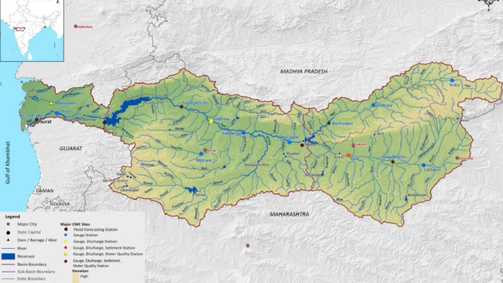
The Tapti River, also referred to as the Tapi, is one of the most critical river systems in Peninsular India. Distinguishing itself as a major west-flowing river, it carves a path through the heart of Central India, sustaining the socio-economic and agricultural fabric of Madhya Pradesh, Maharashtra, and Gujarat. Often called the “Twin” or “Handmaid” of the Narmada, the Tapti plays a pivotal role in the region’s hydrology, ecology, and industrial development.
Spanning approximately 724 kilometers, the river is a lifeline for major urban centers like Surat, Burhanpur, and Bhusawal, providing essential water for irrigation, hydropower, and domestic consumption.
1. Origin and Course of the Tapti River
The Tapti River originates in the rugged terrain of the Satpura Range. Its journey from the mountains to the sea is a defining feature of the Indian Deccan Plateau’s drainage pattern.
1 Source: The river rises in the Multai reserve forest in the Betul district of Madhya Pradesh. It begins its journey at an elevation of 752 meters above sea level.
2 Geographical Extent: It flows westward for nearly 724 km before draining into the Arabian Sea through the Gulf of Khambhat (Gulf of Cambay).
3 Regional Coverage: The system travels through the fertile plains of Vidarbha, Khandesh, and Gujarat. While it touches three states, the largest portion of its drainage area lies within Maharashtra.
4 Boundaries: The Tapti basin is geographically anchored by the Satpura Range to the north, the Mahadev Hills to the east, the Ajanta Range and Satmala Hills to the south, and the Arabian Sea to the west.
2. Comprehensive List of Tapti River Tributaries
The Tapti River system is fed by numerous tributaries, with the left-bank tributaries generally commanding a larger drainage area than those on the right bank.
| Tributary | Bank | Length (km) | Key Characteristics |
| Purna | Left | – | The primary left-bank tributary; it is unique as the only river flowing in the upper basin of peninsular India. |
| Girna | Left | – | Named after Goddess Parvati, it originates in the Western Ghats and flows northward to meet the Tapti. |
| Aner | Right | – | Recognized as the largest right-bank tributary of the Tapti River system. |
| Waghur | Left | 96 | Originating in the Ajanta Range, this river flows north to join the main stream. |
| Burray | Left | 64 | Rising in the Satmala Range, it flows eastward before its confluence with the Tapti. |
| Gomai | Right | 58 | A right-bank tributary that originates in the Satpura Range. |
| Arunavati | Left | 64 | Flows from the southern slopes of the Satpura Range. |
| Bori | Left | – | Originates in Nashik; its course shifts from East to North before merging with the Tapti. |
| Panjhra | Left | – | Notable for the Latiapada Dam constructed near its source. |
3. Characteristics of the Tapti River Basin
The Tapti River Basin is an expansive ecological zone covering 65,145 square kilometers. It is characterized by a mix of steep forested highlands and vast alluvial plains.
1 Dimensions: The basin has a maximum length of 534 km and a maximum breadth of 196 km.
2 Topography: The upper reaches are steep and densely forested, providing a natural habitat for diverse flora and fauna. In contrast, the lower reaches consist of wide, fertile plains.
3 Land Use: Agriculture is the dominant activity, occupying approximately 66.19% of the basin area. Water bodies and reservoirs account for about 2.99% of the total area.
4 Economic Impact: The river basin is the backbone of the regional economy, supporting high-intensity farming and industrial hubs, particularly in the textile and diamond sectors of Gujarat.
4. Soil Profile and Agricultural Suitability
The geological composition of the Tapti basin is highly conducive to agriculture, particularly for cash crops.
1 Black Soils: The majority of the basin is covered in Regur (Black Soil), which is moisture-retentive and ideal for cotton cultivation.
2 Soil Categorization: Up to the Ukai Dam, the soil is divided into three types: coarse shallow soils, medium black soils, and deep black soils.
3 Alluvial Deposits: The coastal plains of Gujarat are enriched with alluvial clays topped with a layer of black soil, making the delta region exceptionally fertile.
FAQs: Tapti River System
IN WHICH STATE DOES THE TAPTI RIVER ORIGINATE?
The Tapti River originates in the Multai reserve forest of the Betul district in Madhya Pradesh.
WHICH IS THE LARGEST TRIBUTARY OF THE TAPTI RIVER?
The Purna River is the major left-bank tributary, while the Aner River is the largest right-bank tributary.
WHY IS THE TAPTI CALLED THE “TWIN” OF THE NARMADA?
It is called the “twin” because it flows parallel to the Narmada River in a rift valley, and both are the primary west-flowing rivers of the Indian peninsula.
WHAT IS THE TOTAL LENGTH OF THE TAPTI RIVER?
The total length of the Tapti River is approximately 724 kilometers.
WHICH MAJOR CITIES ARE LOCATED ON THE BANKS OF THE TAPTI?
Major cities include Surat in Gujarat, and Bhusawal and Burhanpur in Maharashtra and Madhya Pradesh respectively.
WHERE DOES THE TAPTI RIVER EMPTY?
The river drains into the Arabian Sea through the Gulf of Khambhat (Gulf of Cambay).
WHICH MOUNTAIN RANGES BORDER THE TAPTI BASIN?
The basin is bordered by the Satpura Range to the north, Mahadev Hills to the east, and the Ajanta and Satmala Hills to the south.
WHAT IS THE MAIN SOIL TYPE FOUND IN THE TAPTI BASIN?
The basin primarily consists of Black Soil (Regur), which is highly suitable for growing cotton.
WHICH DAM IS BUILT ON THE TAPTI RIVER?
The Ukai Dam (Vallabh Sagar) is one of the most significant dams built on the Tapti River in Gujarat for irrigation and power.
WHAT IS THE DIRECTION OF FLOW OF THE TAPTI RIVER?
The Tapti River flows in a Westward direction, which is rare for large peninsular rivers in India.