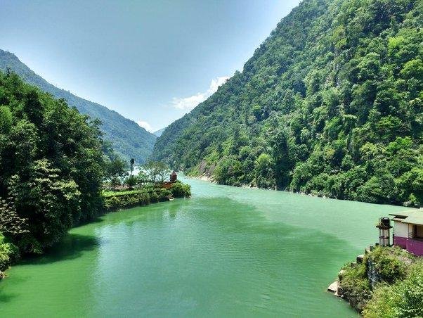
The Teesta River is the largest and most vital river of Sikkim and North Bengal. As a major right-bank tributary of the Brahmaputra (known as the Jamuna in Bangladesh), it acts as the lifeline for millions of people. Flowing through the rugged terrain of the Eastern Himalayas, it is renowned for its deep crystalline gorges, high-speed currents suitable for whitewater rafting, and its role as a source of significant hydroelectric power.
Geographical Course and Origin
- Source: The river originates at a staggering elevation of 5,280 meters from the Tso Lhamo Lake in North Sikkim. It is primarily glacier-fed, receiving water from the Pahurni and Khangse glaciers.
- Himalayan Descent: From its source, it carves a path southward, creating a deep gorge through the Siwalik Hills to the east of Darjeeling.
- The Plains: It enters the plains of West Bengal through the Sivok Khola pass.
- International Border: After traversing North Bengal, the river crosses into Bangladesh, where it eventually merges with the Jamuna (Brahmaputra) River.
- Statistics: The total length of the river is approximately 414 kilometers. About 83% of its catchment basin is located in India, while the remaining 17% lies in Bangladesh.
Hydrological Structure: Major Tributaries
The Teesta is fed by several high-altitude streams and rivers that contribute to its perennial flow.
1. Right Bank Tributaries
- Rangit River: The most significant tributary of the Teesta. The confluence of the Teesta and Rangit (known as Triveni) is a major landmark and a popular spot for river rafting.
2. Left Bank Tributaries
- Lachung Chhu: Originates in North Sikkim and joins the main stream at Chungthang.
- Dik Chhu: A significant stream contributing to the middle course.
- Rangpo Chhu: Forms part of the boundary between Sikkim and West Bengal.
Hydroelectric Projects and Barrages
The steep gradient of the Teesta makes it one of India’s most important rivers for “run-of-the-river” hydroelectric power generation.
Key Projects in India
| Project Name | Capacity | Location |
| Teesta-III Dam | 1,200 MW | Mangan District, Sikkim |
| Teesta-V Dam | 510 MW | Gangtok District, Sikkim |
| Teesta Low Dam III & IV | 132 MW & 160 MW | Kalimpong, West Bengal |
| Gajoldoba Barrage | Irrigation | Jalpaiguri, West Bengal |
Key Infrastructure in Bangladesh
- Duani Barrage: A vital structure used for large-scale irrigation in the northern districts of Bangladesh.
- Barakhata Teesta Barrage: Another essential component for the agricultural stability of the downstream region.
Socio-Economic and Strategic Importance
- Agriculture: The Teesta provides water for the “Teesta Barrage Project,” which is one of the largest irrigation projects in Eastern India, covering several districts of North Bengal.
- Adventure Tourism: Its turbulent waters are world-famous for whitewater river rafting, attracting thousands of tourists to Sikkim and West Bengal annually.
- Geopolitics: The sharing of Teesta’s waters remains a core diplomatic issue between India and Bangladesh. Negotiations focus on the equitable distribution of water, especially during the lean dry season.
Frequently Asked Questions (FAQs)
WHERE IS THE EXACT ORIGIN OF THE TEESTA RIVER?
The river originates from Tso Lhamo Lake in North Sikkim, at an altitude of approximately 5,280 meters.
WHICH RIVER DOES THE TEESTA JOIN IN BANGLADESH?
It joins the Brahmaputra River, which is locally referred to as the Jamuna in Bangladesh.
WHICH IS THE LARGEST TRIBUTARY OF THE TEESTA?
The Rangit River is the largest and most important tributary of the Teesta.
HOW MANY COUNTRIES DOES THE TEESTA FLOW THROUGH?
The river flows through two countries: India (Sikkim and West Bengal) and Bangladesh.
WHAT PERCENTAGE OF THE TEESTA BASIN LIES IN INDIA?
Approximately 83% of the Teesta River basin is located within India.
WHICH BARRAGE IN WEST BENGAL IS USED FOR IRRIGATION ON THE TEESTA?
The Gajoldoba Barrage is the primary structure in West Bengal used to divert Teesta water for irrigation.
IS THE TEESTA A RAIN-FED OR GLACIER-FED RIVER?
The Teesta is a glacier-fed river, with its primary water sources being the Pahurni and Khangse glaciers.
WHICH HYDROELECTRIC PROJECT ON THE TEESTA HAS THE HIGHEST CAPACITY?
The Teesta-III Dam in Sikkim is the largest, with a generating capacity of 1,200 MW.
WHAT IS THE TOTAL LENGTH OF THE TEESTA RIVER?
The river spans a total length of approximately 414 kilometers.
WHY IS THE TEESTA IMPORTANT FOR ADVENTURE SPORTS?
Due to its steep descent and rocky bed, the Teesta provides high-grade rapids that are ideal for whitewater rafting.