
Context
The UN Transitional Assistance Mission in Somalia (UNTMIS) ended operations on 31 October 2026, amid an unresolved electoral dispute and no agreed replacement mechanism, raising concerns over Somalia’s political stability.
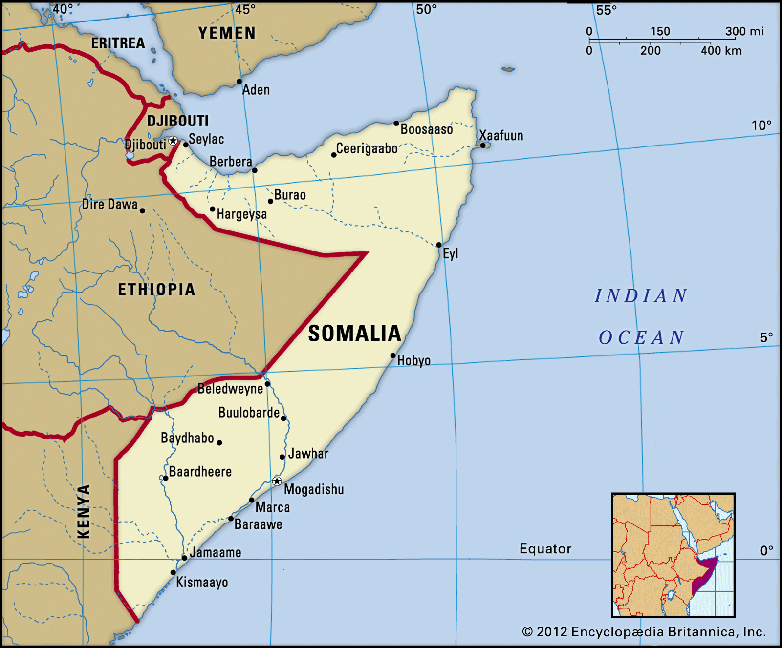
Somalia: Physical & Political Geography
- Location: Situated in the Horn of Africa; crossed by the Equator in its southern territory.
- Geographical Boundaries:
- Land Borders: Djibouti (North-west), Ethiopia (West), and Kenya (South-west).
- Maritime Borders: Gulf of Aden (North) and Indian Ocean (East).
3. Strategic Significance: Boasts the longest coastline on mainland Africa; guards the Bab-el-Mandeb and Gulf of Aden maritime chokepoint for global anti-piracy operations.
4. Capital & Governance:
- Capital: Mogadishu
- Polity: Federal Republic; Somaliland claims independence but lacks UN recognition.
- Regional Bloc: Admitted into the EAC (East African Community) in 2024.
5. Climate & Topography: Predominantly arid to semi-arid; landscape is mainly a limestone and sandstone plateau with a dry coastal plain (Guban) along the Gulf of Aden.
6. Highest Peak: Mount Shimbiris (~2,400 m).
7. Major River Systems: Jubba River and Shabelle River, both originating in the Ethiopian Highlands.
8. Mineral Wealth: Holds deposits of iron ore, uranium, copper, tin, bauxite, and gypsum, which remain largely unexploited.
United Nations Transitional Assistance Mission in Somalia (UNTMIS)
- Establishment & Predecessor: Formed under UNSC (United Nations Security Council) Resolution 2753 on 1 November 2024, succeeding the UNSOM (United Nations Assistance Mission in Somalia).
- Mandate Period: Operating from 1 November 2024 to 31 October 2026 to oversee a structured, phased drawdown.
- Core Purpose: Designed to transition peacebuilding, democratic governance, and rule of law responsibilities directly to Somali national institutions and localized UN agencies.
- Strategic Focus: Shift away from direct UN administration toward sovereignty transfer, capacity-building, and long-term security autonomy for Somalia.
FAQs
Q1. What was the main purpose of UNTMIS?
Ans. To support peacebuilding, democratic governance and the rule of law in Somalia.
Q2. Why is Somalia strategically important?
Ans. Its location near the Gulf of Aden and Bab-el-Mandeb Strait makes it vital for global maritime trade and security.
Q3. Name the highest peak of Somalia.
Ans. Mount Shimbiris.