- Courses
- GS Full Course 1 Year
- GS Full Course 2 Year
- GS Full Course 3 Year
- GS Full Course Till Selection
- Answer Alpha: Mains 2025 Mentorship
- MEP (Mains Enrichment Programme) Data, Facts
- Essay Target – 150+ Marks
- Online Program
- GS Recorded Course
- Polity
- Geography
- Economy
- Ancient, Medieval and Art & Culture AMAC
- Modern India, Post Independence & World History
- Environment
- Governance
- Science & Technology
- International Relations and Internal Security
- Disaster Management
- Ethics
- NCERT Current Affairs
- Indian Society and Social Issue
- NCERT- Science and Technology
- NCERT - Geography
- NCERT - Ancient History
- NCERT- World History
- NCERT Modern History
- CSAT
- 5 LAYERED ARJUNA Mentorship
- Public Administration Optional
- ABOUT US
- OUR TOPPERS
- TEST SERIES
- FREE STUDY MATERIAL
- VIDEOS
- CONTACT US
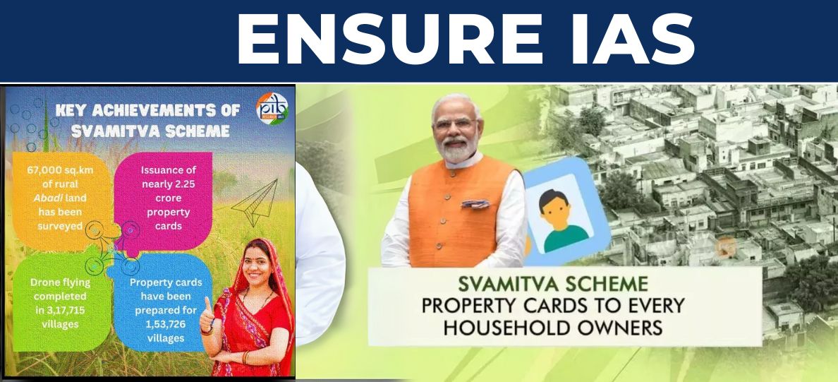
SVAMITVA Scheme: Property Cards for Villages
SVAMITVA Scheme: Property Cards for Villages
- On January 18, 2025 Prime Minister Narendra Modi said, once property cards under the Centre’s SVAMITVA scheme have been distributed in all the villages of the country, it could unlock economic activity worth over Rs 100 lakh crore.
- SVAMITVA stands for Survey of Villages and Mapping with Improvised Technology in Village Areas.
- For decades, the survey and settlement of rural land in India were incomplete, with many states not mapping or documenting the ‘abadi’ (inhabited) areas of villages.
- This lack of legal records left property owners without formal documents, making it difficult for them to access loans or use their property as financial assets, stopping economic growth in rural areas.
- To address this, Prime Minister Narendra Modi launched the SVAMITVA scheme, using advanced drone technology to survey and map these ‘abadi’ areas.
- Launched On April 24, 2020 (National Panchayati Raj Day)
- Property cards distribution started on : October 11, 2020.
- Scheme aims to provide property owners with a legal record of rights, which will help them:
- Monetize property
- Access bank loans
- Reduce property disputes
- Promote village-level planning
- The goal of the scheme is to survey rural properties using drones and create maps for each village, which will officially recognize who owns what land.
Who Benefits from the SVAMITVA Scheme?
- Rural People
- Small Farmers and Village Entrepreneurs.
- Local Governments (Gram Panchayats).
How Does the SVAMITVA Scheme Work?
- The government uses drones to fly over and prepare GIS -based maps for each village.
- Geographic Information Systems (GIS) based maps are maps created using technology that combines different types of geographic data, like roads, land use, or population, to show detailed information about an area.
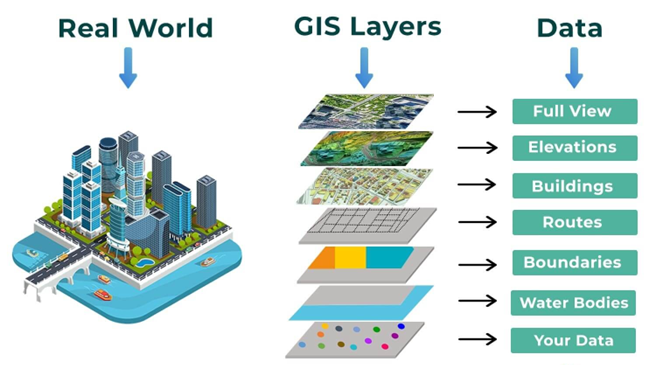
- The images from the drones are used to create detailed maps that show exactly where each property is.
- The Survey of India (SoI) works with state governments to collect information about land and prepare maps.
- They use satellites and airplanes along with drones to get accurate data.
- After mapping the land, the government checks the data on the ground to make sure everything is correct. If there are any mistakes or disputes, they are resolved during this process.
- Once everything is verified, property cards are created and given to the people who own the land. These cards serve as official proof of ownership.
- The property records are shared with Gram Panchayats (local councils) to help them plan better for the development of the village and collect taxes properly.
|
The Survey of India is the oldest scientific department of the Government of India, established in 1767. It operates under the Department of Science & Technology and plays a crucial role in mapping and surveying the country. Key responsibilities include:
|
Benefits of the SVAMITVA Scheme
- With the property card, villagers can use their homes as collateral to get loans from banks to start or grow businesses or make improvements in their lives.
- The property card gives villagers official proof of ownership, making them feel more secure and confident in their financial matters.
- With accurate property records, local authorities can collect property taxes more easily, which helps them improve village infrastructure.
- The property cards make it easier to buy and sell land, as everyone has clear proof of who owns what property.
- Clear and accurate records help in solving land disputes and avoiding illegal occupation of land.
- Prime Minister Modi has said that once the SVAMITVA scheme is completed across all villages, it could unlock Rs. 100 lakh crore worth of economic activity.
How is the SVAMITVA Scheme Implemented?
- The Survey of India (SoI) signs an Memorandum of Understanding (MoU) with state governments to begin the scheme, and they work together to map the land.
- Drones are used to collect images of land in rural areas, and these images are turned into detailed maps that are shared with the villagers.
- After the maps are made, teams go to the villages to check the data and make sure everything is correct. If there are any errors or disputes, they are fixed at this stage.
- After the data is verified, property cards are created and given to the landowners. These cards serve as the official record of ownership.
Key Data and Facts:
|
Conclusion
The SVAMITVA scheme is a game-changing initiative for rural India, offering legal recognition of property ownership, improving land management, and empowering villagers to access financial support. The scheme's use of drones and GIS technology is not only modernizing land records but also contributing to the growth of rural economies. With its successful progress and international recognition, the SVAMITVA scheme is likely to play a key role in improving the financial well-being of millions of rural households across the country.

|
Also Read |
|
| FREE NIOS Books | |
India's 2027 Digital Census Notified
India’s Nuclear Liability Law Debate
Balancing Power and Trust in the Bay of Bengal
Karol Bagh Metro Pillar No. 112, Above Domino's, 22B, First Floor, New Delhi - 110060
Very Important Instruction For Any Issue, Student Must Produce His/Her Fee Receipt. Without Fee Receipt, It Will Not Be Possible To Track Your Details. If You Have Been Given Any Special Consideration, You Must Keep That In Writing And Produce In Case Of Conflict.
Copyright © 2024-2026 ENSURE IAS. All rights reserved.