- Courses
- GS Full Course 1 Year
- GS Full Course 2 Year
- GS Full Course 3 Year
- GS Full Course Till Selection
- Online Program
- GS Recorded Course
- NCERT (Recorded 500+ Hours)
- Polity Recorded Course
- Geography Recorded Course
- Economy Recorded Course
- AMAC Recorded Course
- Modern India, Post Independence & World History
- Environment Recoded Course
- Governance Recoded Course
- Science & Tech. Recoded Course
- International Relations and Internal Security Recorded Course
- Disaster Management Module Course
- Ethics Recoded Course
- Essay Recoded Course
- Current Affairs Recoded Course
- CSAT
- 5 LAYERED ARJUNA Mentorship
- Public Administration Optional
- ABOUT US
- OUR TOPPERS
- TEST SERIES
- FREE STUDY MATERIAL
- VIDEOS
- CONTACT US
PLACES IN NEWS 9th MAY 2025
PLACES IN NEWS 9th MAY 2025
Persian Gulf
Why in news?
a. During a Saudi Arabia visit, President Trump plans to rename the 'Persian Gulf' as 'Arabian Gulf,' supporting Arab nations' preference.
About Persian Gulf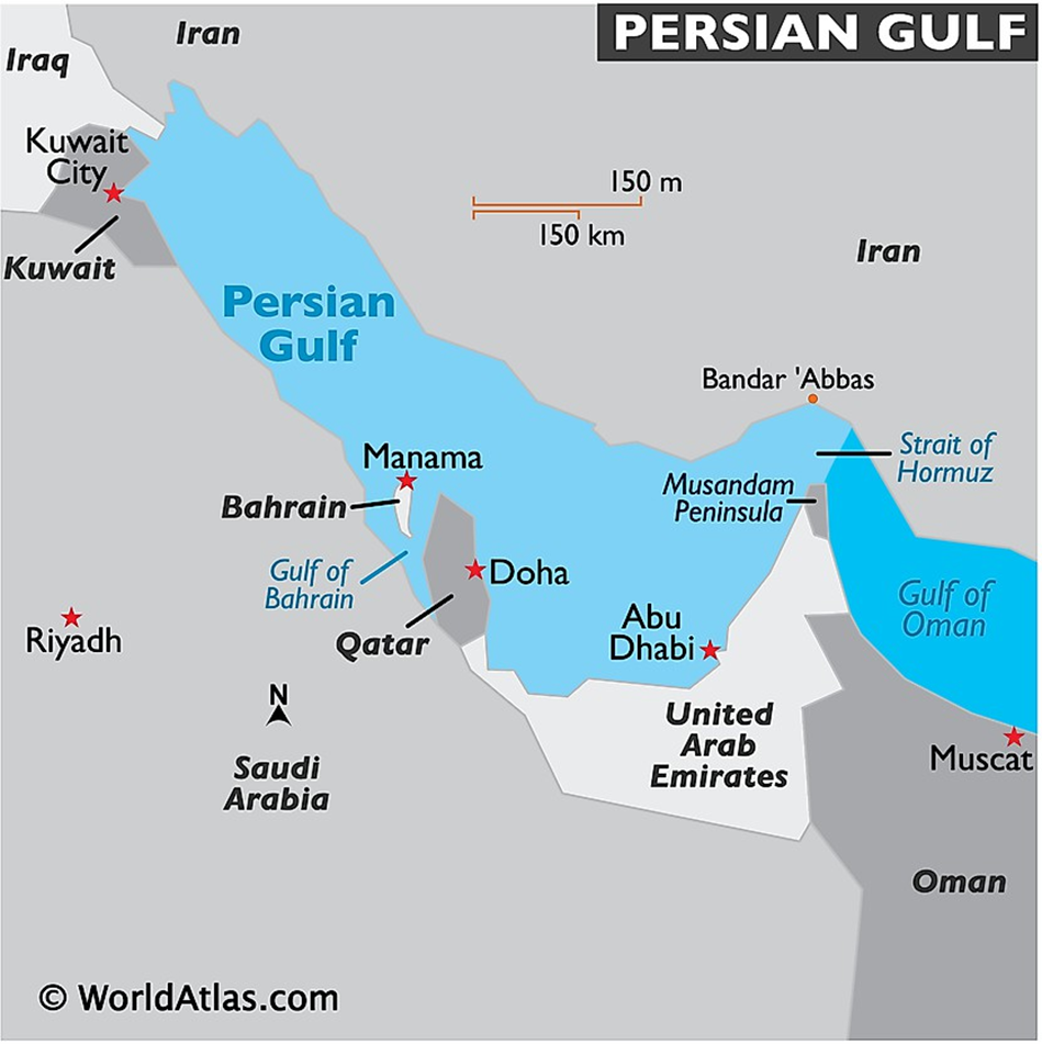
- Location and Geography:
- The Persian Gulf, a Mediterranean sea in Western Asia, is located between Iran to the northeast and the Arabian Peninsula (including countries like Saudi Arabia, UAE, Oman, Qatar, Bahrain, and Kuwait) to the southwest.
- It stretches approximately 990 kilometres from the Shatt al-Arab river delta to the Strait of Hormuz, where it opens into the Gulf of Oman and the Arabian Sea.
- The gulf is relatively shallow, with an average depth of about 50 meters, and features numerous islands, coral reefs, and submerged banks.
- Major rivers like the Tigris, Euphrates, and Karun empty into the Gulf, forming an ecologically sensitive estuarine zone in the north.
- The region is largely arid, with vast deserts and minimal rainfall, making the gulf’s coastal and marine ecosystems critically important.
- Economic Resources and Trade:
- The Persian Gulf is globally renowned for its abundant hydrocarbon resources, containing a significant share of the world’s proven oil and natural gas reserves.
- Countries bordering the Gulf—especially Saudi Arabia, Iran, Iraq, Kuwait, Qatar, and the UAE—are among the top global oil exporters.
- The region is home to massive offshore oilfields such as Safaniya (the world’s largest offshore oilfield) and major natural gas fields like South Pars/North Dome.
- At the southeastern end of the gulf, the Strait of Hormuz is a vital maritime chokepoint through which nearly 20% of global oil trade passes.
- The gulf also supports industries like petrochemicals, shipping, desalination, and increasingly, renewable energy and tourism.
- Geopolitical Significance:
- The Persian Gulf holds immense geopolitical importance as a nexus of energy security, regional rivalry, and global strategic interests.
- Tensions frequently arise between Iran and Gulf Cooperation Council (GCC) countries, often exacerbated by sectarian divisions (Shia vs. Sunni) and foreign military presence.
- The United States maintains a strong naval presence, including the Fifth Fleet in Bahrain, to ensure maritime security and deter aggression.
- China and India are also increasingly involved in the region through strategic oil partnerships and infrastructure investments.
- The Gulf's stability is essential for global energy markets, and any disruption—whether through conflict, piracy, or sanctions—can have worldwide economic repercussions.
Anak Krakatau
Why in news?
a. Satellite radar analysis reveals years of unnoticed ground movement before Anak Krakatau’s deadly 2018 collapse, previously undetected by conventional methods.
About Anak Krakatau
- Location:
- Anak Krakatau (meaning “Child of Krakatau”) is a stratovolcano situated in the
Sunda Strait, between the Indonesian islands of Java and Sumatra.
-
- It emerged from the sea in 1927, forming in the caldera left by the catastrophic
Krakatoa eruption of 1883.
-
- Part of the Pacific Ring of Fire, Anak Krakatau is one of the most active volcanoes in Indonesia, sitting above a complex system of magma chambers that fuel frequent eruptions.
- Ground Movement:
- Anak Krakatau has experienced frequent volcanic activity, with at least nine eruption episodes since 1963, typically of strombolian type, marked by moderate explosions.
- On 22 December 2018, a major eruption triggered the collapse of the volcano’s southwestern flank, causing a massive underwater landslide.
- This sudden collapse displaced seawater and generated a tsunami that struck the coastal regions of southern Sumatra and western Java, killing over 400 people and injuring thousands.
- Post-disaster studies revealed that the volcano had shown significant ground deformation in the years preceding the collapse—slow, unnoticed movements that were not detected by conventional monitoring tools.
- New Methods of Detection:
- Advanced technologies like satellite radar interferometry (InSAR) have now allowed scientists to analyse subtle ground movements at volcanoes like Anak Krakatau.
- By comparing satellite radar images taken over time, researchers detected that the southwestern flank of the volcano had been slowly shifting for years before the 2018 collapse.
- These findings highlight the importance of remote sensing tools in monitoring volcanic hazards, especially in remote or maritime volcanoes where ground-based instruments are limited.
- Such technologies can provide early warnings for potential collapses and tsunamis, improving disaster preparedness and risk mitigation in vulnerable coastal regions.
Nagarhole National Park
Why in news?
a. Jenu Kuruba families have recently started returning to their ancestral homes within Nagarhole National Park after a long wait.
About Nagarhole National Park:
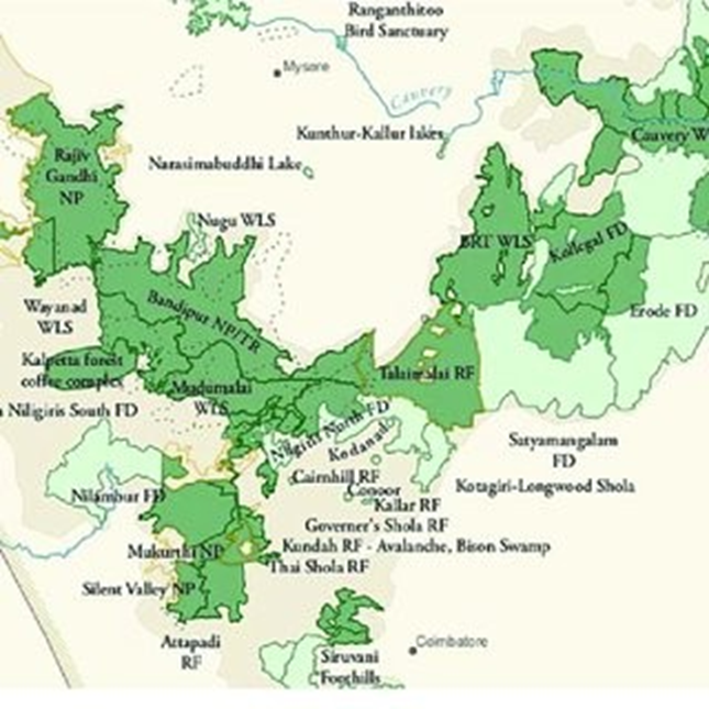
- Location and Geography:
- Nagarhole National Park, also known as Rajiv Gandhi National Park, is located in the Kodagu and Mysuru districts of Karnataka, India.
- It forms a crucial part of the Nilgiri Biosphere Reserve, a UNESCO-designated site, and is ecologically connected to other key protected areas such as Bandipur National Park, Wayanad Wildlife Sanctuary in Kerala, and Mudumalai Tiger Reserve in Tamil Nadu.
- The park stretches across the Western Ghats and Deccan Plateau, featuring gently undulating terrain, rich river systems including the Kabini River, and seasonal streams that support dense vegetation.
- Its strategic location makes it vital for wildlife corridors and long-range migration of large mammals, especially elephants and tigers.
- Flora and Fauna:
- Nagarhole is dominated by moist deciduous and dry deciduous forests, interspersed with swampy grasslands, also known as hadlus, which serve as grazing grounds for herbivores.
- The park hosts a rich diversity of trees, including rosewood, teak, sandalwood, and terminalia species.
- It supports over 250 bird species and numerous mammals such as the Bengal tiger, Indian elephant, gaur, dhole, leopard, and sloth bear.
-
- The presence of aquatic bodies also sustains mugger crocodiles, amphibians, and several fish species.
- Tribal Presence:
- The park is home to several indigenous communities, notably the Jenu Kuruba, Betta Kuruba, and Yerava tribes, who have traditionally lived in and around the forest.
- The Jenu Kuruba (literally “honey collectors”) have deep cultural and subsistence ties to the forest, relying on non-timber forest products like honey and medicinal plants.
- In recent developments, Jenu Kuruba families have begun reoccupying their ancestral homes inside Nagarhole after long-standing struggles for recognition and rights under the Forest Rights Act, 2006.
- This marks a step towards tribal empowerment and coexistence-based conservation in India’s protected areas.
Mithi River
Why in news?
a. Mumbai police’s EOW arrests 2 middlemen in multi-crore Mithi River desilting scam.
About Mithi River:
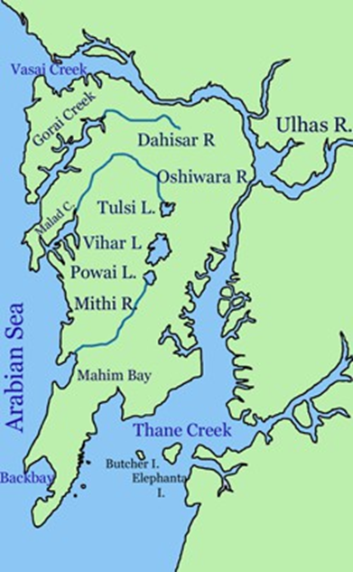
- Origin and Course:
- The Mithi River is a seasonal river located on Salsette Island, which houses the city of Mumbai, India.
- It originates from the overflow of Vihar Lake, and around 2 km downstream, it is joined by the overflow from Powai Lake.
- The river flows for approximately 18 kilometres, passing through several densely populated and industrial areas including Powai, Saki Naka, Kurla, Kalina, Bandra Kurla Complex, Dharavi, and finally Mahim, where it drains into the Arabian Sea via Mahim Creek.
- Following the devastating Mumbai floods of 26 July 2005, the river’s width was increased from an average of 5 meters in its upper reaches to 70 meters in the lower stretches to improve water flow.
- Desiltation Scam:
- The Mithi River has suffered severe environmental degradation due to unchecked dumping of industrial waste, sewage, animal waste, and hazardous materials, significantly reducing its carrying capacity.
- To mitigate future flood risks, the Brihanmumbai Municipal Corporation (BMC) initiated a desiltation and cleanup project.
- However, the effort has been marred by a multi-crore scam, where contractors allegedly inflated bills and reported fake volumes of silt removed.
-
- In a recent development, Mumbai Police’s Economic Offences Wing (EOW) arrested two middlemen for their involvement in the scam, highlighting deep-rooted corruption in civic contracts and undermining the city's flood-prevention infrastructure.
|
Also Read |
|
UPSC Foundation Course |
|
| UPSC Monthly Magazine | CSAT Foundation Course |

CCRAS has revived two rare Ayurvedic Manuscript

477 Snow Leopards in Ladakh: Study
PLACES IN NEWS 9th MAY 2025
Karol Bagh Metro Pillar No. 112, Above Domino's, 22B, First Floor, New Delhi - 110060
Copyright © 2024-2026 ENSURE IAS. All rights reserved.