- Courses
- GS Full Course 1 Year
- GS Full Course 2 Year
- GS Full Course 3 Year
- GS Full Course Till Selection
- Answer Alpha: Mains 2025 Mentorship
- MEP (Mains Enrichment Programme) Data, Facts
- Essay Target – 150+ Marks
- Online Program
- GS Recorded Course
- Polity
- Geography
- Economy
- Ancient, Medieval and Art & Culture AMAC
- Modern India, Post Independence & World History
- Environment
- Governance
- Science & Technology
- International Relations and Internal Security
- Disaster Management
- Ethics
- NCERT Current Affairs
- Indian Society and Social Issue
- NCERT- Science and Technology
- NCERT - Geography
- NCERT - Ancient History
- NCERT- World History
- NCERT Modern History
- NCERT Medieval History
- CSAT
- 5 LAYERED ARJUNA Mentorship
- Public Administration Optional
- ABOUT US
- OUR TOPPERS
- TEST SERIES
- FREE STUDY MATERIAL
- VIDEOS
- CONTACT US
PLACES IN NEWS 9th JULY 2025
PLACES IN NEWS 9th JULY 2025
09-07-2025
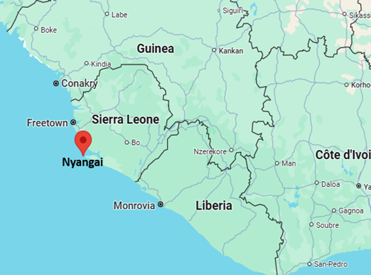
Sierra Leone
Why in the News?
- Nyangai, part of the Turtle Islands in southern Sierra Leone, is facing severe land erosion due to rising Atlantic sea levels and climate change.
- The island has lost two-thirds of its surface area, now measuring just 200 m long and 100 m wide.
- The crisis is impacting the livelihood and survival of its residents, especially fishermen.
- The situation highlights the vulnerability of low-lying coastal communities despite their minimal contribution to global warming.
- It serves as a powerful example of climate injustice, where the least polluting communities suffer the most from the consequences of climate change.
About Sierra Leone
- Location: Sierra Leone is a tropical country in West Africa, situated along the Atlantic Ocean.
- Borders: It shares borders with Guinea to the north and east, Liberia to the south, and the Atlantic Ocean to the west.
- Geography: The country features lightly wooded hills inland and mangrove swamps along its coastline.
- Major Rivers: Key rivers include the Rokel, Taia, Moa, and Sewa rivers.
- Political System
- Sierra Leone is a constitutional republic with a directly elected President and a unicameral legislature.
- Capital: Freetown, which has one of the world’s largest natural harbours.
- Economy
- While most people engage in subsistence farming, Sierra Leone is also known for its mineral wealth.
- Key resources include diamonds, gold, bauxite, and rutile (used to produce titanium dioxide).
Red Sea
Why in the News?
- Yemen's Houthi rebels attacked a Liberian-flagged cargo ship in the Red Sea, resulting in the death of three mariners and injuries to two others.
- This is part of a series of Houthi-led attacks on commercial shipping in the region since November 2024, threatening a vital global maritime trade route.
- The ship came under attack while moving toward the Suez Canal, highlighting the escalating risks to international shipping and the region’s strategic importance.
- The European Union naval force confirmed the attack and casualty details, marking increased international concern over maritime security in the Red Sea.
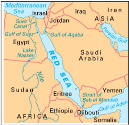
About Red Sea
- The Red Sea is a narrow inlet of the Indian Ocean located between the continents of Africa and Asia.
- An inlet is a narrow strip of water extending from a sea or lake into the land or between islands.
- It is one of the world’s northernmost tropical seas and also among the busiest maritime trade routes globally.
- It connects to the Indian Ocean in the south through the Bab el-Mandeb Strait and the Gulf of Aden.
- In the north, the Red Sea is divided by the Sinai Peninsula into two arms:
- The Gulf of Aqaba
- The Gulf of Suez, which further connects to the Mediterranean Sea via the Suez Canal.
- The Red Sea is part of the Great Rift Valley, specifically the Afro-Arabian Rift System, which is geologically active.
- Bordering Countries:
- East: Saudi Arabia and Yemen
- North: Egypt
- West: Sudan, Eritrea, Djibouti
- Other Characteristics
- It stretches approximately 2,250 km and has a surface area of around 438,000 sq. km.
- Its name likely comes from occasional reddish-brown algae blooms (Trichodesmium erythraeum) that change the water’s colour.
- Notable Islands include Tiran Island (near the Gulf of Aqaba) and Shadwan Island (near the Gulf of Suez).

PLACES IN NEWS 9th JULY 2025
Melting Glaciers and Volcanoes: Uncovering the Hidden Risks of Climate Change
BRICS vs Europe’s CBAM: Climate and Trade Tensions
Karol Bagh Metro Pillar No. 112, Above Domino's, 22B, First Floor, New Delhi - 110060
Very Important Instruction For Any Issue, Student Must Produce His/Her Fee Receipt. Without Fee Receipt, It Will Not Be Possible To Track Your Details. If You Have Been Given Any Special Consideration, You Must Keep That In Writing And Produce In Case Of Conflict.
Copyright © 2024-2026 ENSURE IAS. All rights reserved.