- Courses
- GS Full Course 1 Year
- GS Full Course 2 Year
- GS Full Course 3 Year
- GS Full Course Till Selection
- Online Program
- GS Recorded Course
- NCERT (Recorded 500+ Hours)
- Polity Recorded Course
- Geography Recorded Course
- Economy Recorded Course
- AMAC Recorded Course
- Modern India, Post Independence & World History
- Environment Recoded Course
- Governance Recoded Course
- Science & Tech. Recoded Course
- International Relations and Internal Security Recorded Course
- Disaster Management Module Course
- Ethics Recoded Course
- Essay Recoded Course
- Current Affairs Recoded Course
- CSAT
- 5 LAYERED ARJUNA Mentorship
- Public Administration Optional
- ABOUT US
- OUR TOPPERS
- TEST SERIES
- FREE STUDY MATERIAL
- VIDEOS
- CONTACT US
PLACES IN NEWS 7th MARCH 2025
PLACES IN NEWS 7th MARCH 2025
07-03-2025

Indus River
Why in news?
- Pakistan has discovered massive gold reserves worth around Rs 80,000 crore in the Indus River bed, offering a potential economic boost to the country’s struggling financial situation.
About Indus River:
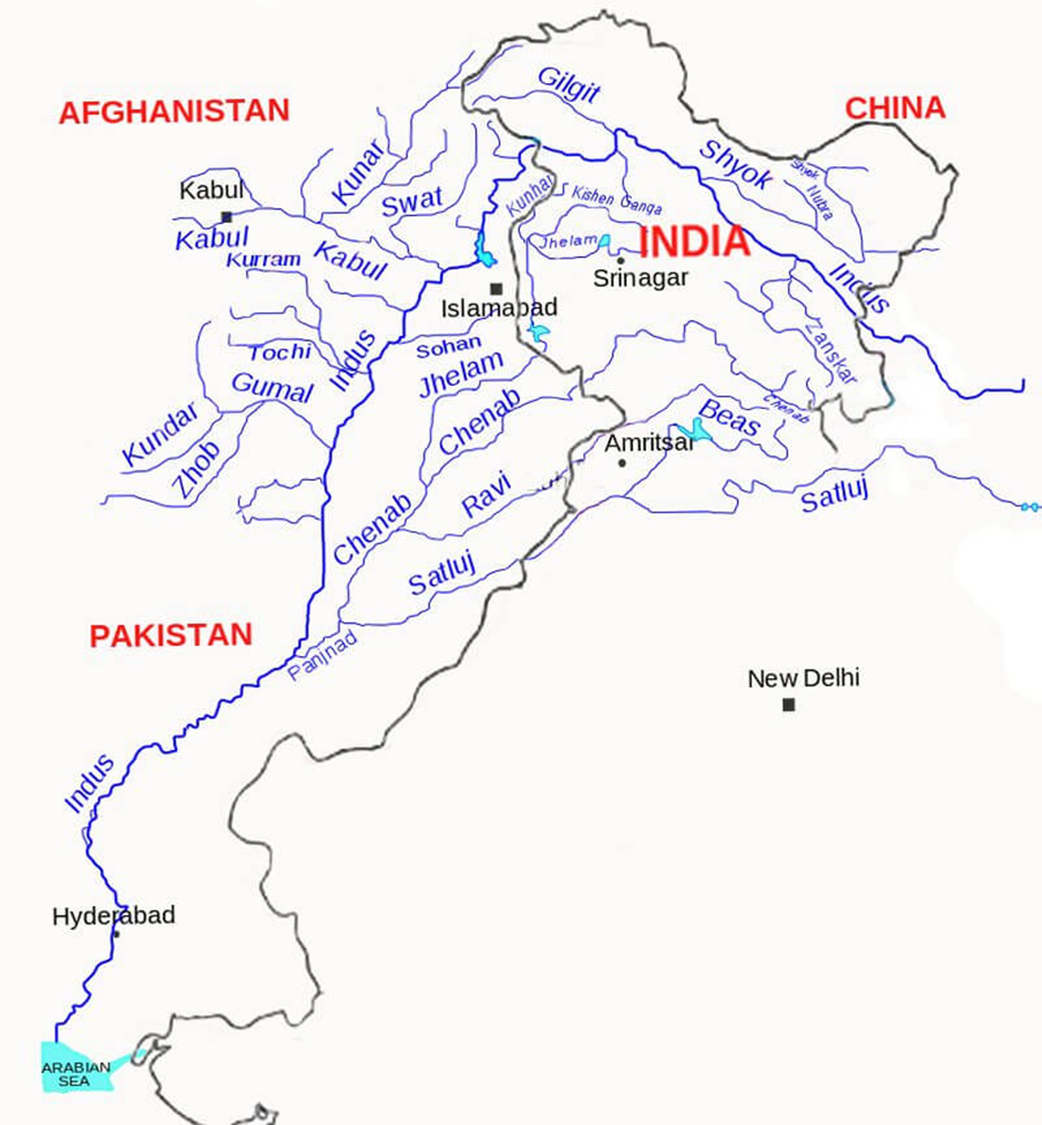
- The Indus River is one of the longest rivers in Asia, originating from a glacier near Bokhar Chu in the Tibetan region within the Kailash Mountain Range, close to Mansarovar Lake.
- It is known as ‘Singi Khamban’ (Lion’s Mouth) in Tibet.
- The river flows northwest and enters India at Demchok in Ladakh, where it courses between the Karakoram and Ladakh ranges before continuing into Pakistan.
- With a total drainage area of approximately 1,120,000 sq. km, it is one of the 50 largest rivers in terms of annual flow, estimated at 175 km³ per year (5,500 m³/s).
- The Indus River basin extends across Tibet (China), India, Pakistan, and Afghanistan, with India’s drainage area covering 321,289 sq. km (9.8% of India's total geographical area).
- It is bounded by the Karakoram and Haramosh ranges in the north, the Himalayas in the east, the Sulaiman and Kirthar ranges in the west, and the Arabian Sea in the south.
- The river is vital for agriculture, hydropower, and human consumption in the region.
- The Indus has several major tributaries. Its left-bank tributaries include the Zanskar River (Ladakh) and the Panjnad River, which forms from the confluence of five Punjab rivers—Jhelum, Chenab, Ravi, Beas, and Sutlej.
- Its right-bank tributaries include the Shyok, Gilgit, Kabul, Kurram, and Gomal rivers.
- The river originates from a mountain spring and is fed by glaciers from the Himalayas, Karakoram, and Hindu Kush ranges, supporting diverse ecosystems, from temperate forests to arid plains.
- Historically, the Indus River played a significant role in the Indus Valley Civilisation (3300 BCE - 1300 BCE), one of the world’s oldest urban cultures.
- Major sites like Harappa and Mohenjo-Daro are located in Pakistan, giving the civilisation its alternate name, the Harappan Culture.
Gold Reserves in the Indus River:
- Pakistan recently discovered vast gold reserves worth approximately ₹80,000 crore in the Indus River bed within the Attock district of Punjab province.
- This discovery was made through a government-commissioned survey and is expected to provide a significant economic boost to the country.
- The mining project will be overseen by NESPAK (National Engineering Services Pakistan) and the Mines and Minerals Department of Punjab.
- Geologists suggest that the Indus carries gold deposits from the Himalayas, accumulating as placer gold or nuggets.
- The State Bank of Pakistan valued the nation’s total gold reserves at $5.43 billion (December 2024).
- Amid economic instability, depleting foreign exchange reserves, and currency depreciation, successful extraction of these reserves could stabilise Pakistan’s economy and enhance its mining industry.
Dnipro River
Why in news?
- Russia is conducting repeated high-casualty assaults to cross the Dnipro River in Kherson, aiming to capture more territory ahead of possible peace negotiations despite significant losses.
About Dnipro River:
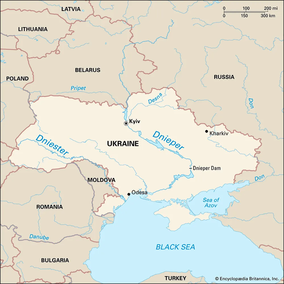
- Origin and Course:
- The Dnipro River originates in Russia, in the low Valday Hills, located west of Moscow.
- Flowing southward for 1,368 miles (2,201 km), it passes through western Russia, Belarus, and Ukraine before emptying into the Black Sea.
- The river is divided among three countries, with approximately 300 miles flowing through Russia, around 430 miles traversing Belarus, and the longest stretch, about 680 miles, lying within Ukraine.
- The Dnipro River Basin spans an area of 504,000 sq. km, with 289,000 sq. km in Ukraine, covering 48% of the country’s landmass.
- This vast basin makes it one of the most significant river systems in Eastern Europe. Characterised by a gentle slope, slow flow, and an unstable riverbed, the river experiences fluctuating water levels.
- Along its course, the Dnipro passes through several major cities, including Smolensk and Dorogobuzh in Russia, Mogilev in Belarus, and Kyiv (the capital of Ukraine), Cherkasy, Dnipro, and Zaporizhzhia in Ukraine.
- Significance of the Dnipro River:
- Strategic Barrier: Historically, the Dnipro divided Ukraine into Right and Left Banks, influencing military and political conflicts, including during World War II and the ongoing Russia-Ukraine war.
- Economic Lifeline: It is Ukraine’s most crucial navigable waterway, supporting trade, agriculture, and hydropower generation.
- Geopolitical Importance: Given its location in a war-torn region, control over the river remains a strategic objective in conflicts, including Russia's attempts to secure key crossings in the ongoing war.
Sajjangarh Wildlife Sanctuary
Why in news?
- A massive fire engulfed Sajjangarh Wildlife Sanctuary in Udaipur, threatening its rich biodiversity.
About Sajjangarh Wildlife Sanctuary:
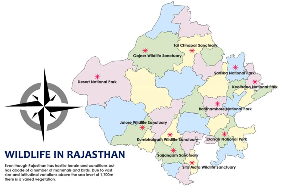
- Location:
- Sajjangarh Wildlife Sanctuary is located in Udaipur District, Rajasthan, within the southern Aravalli Hills.
- Spanning 5.19 square kilometres, it lies atop Bansdara Hill, an ecologically vulnerable region due to overexploitation of resources and unsustainable development.
- The sanctuary experiences hot summers with temperatures reaching 42°C, while winters can drop to 6°C. Rainfall is irregular, averaging 650 mm annually.
- Originally a hunting ground for the Maharanas of Udaipur near the Monsoon Palace, the area was designated a wildlife sanctuary in 1987.
- In 2017, a 28.7 sq. km area around the sanctuary was declared an Eco-Sensitive Zone to protect its fragile ecosystem.
- Flora and Fauna
- Despite being Rajasthan's smallest sanctuary, Sajjangarh Wildlife Sanctuary is home to diverse bird species. Of the 129 recorded species, 81 are resident, 8 are winter migrants, and 2 are passage migrants.
- Notably, it harbours critically endangered vultures such as the red-headed vulture, Indian vulture, and white-rumped vulture, while the Egyptian vulture is classified as endangered.
- The white-naped tit, a rare bird species found in arid regions of India, is also present here.
- The sanctuary also has various native trees and shrubs, which support the local wildlife.
- Cause of Wildfire
- A massive wildfire broke out in the sanctuary, spreading rapidly due to strong winds and affecting an additional 7 hectares.
- The fire threatened the nearby Sajjangarh Biological Park, home to lions, tigers, and leopards, as well as residential areas.
- Authorities evacuated locals, deployed 12 fire tenders, and closed the park to tourists.
- The changing wind direction posed a major challenge, prompting calls for preventive measures like water tanks, sprinklers, and helicopter firefighting operations.
Dholavira
Why in news?
- The President of India visits Dholavira, a UNESCO World Heritage Site in Gujarat, highlighting its significance as an Indus Valley Civilization city known for advanced urban planning, water conservation systems, and archaeological importance.
About Dholavira:
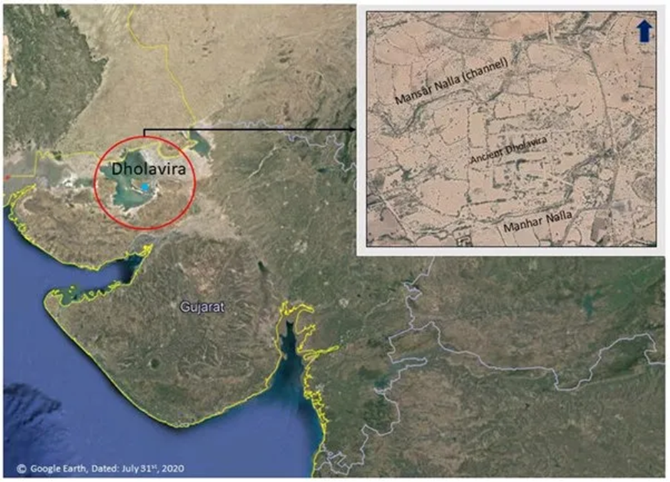
- Location:
- Dholavira is one of the most prominent sites of the Indus Valley Civilisation (IVC) and is located in the Kutch district of Gujarat, India.
- It is situated on the arid Rann of Kutch, within the Khadir Bet island.
- It is the second IVC site in India to receive UNESCO World Heritage Site status, after Rakhigarhi.
- Historical and Cultural Significance
- Dholavira is known for its sophisticated urban planning, showcasing a three-tiered city structure consisting of the Citadel, Middle Town, and Lower Town.
- The site reveals an advanced drainage and water conservation system, including reservoirs, stepwells, and channels, which highlight the inhabitants’ engineering prowess in dealing with the region’s arid climate.
- One of its most striking features is the world’s earliest signboard, discovered at the site, containing ten large Harappan script characters.
- The presence of massive fortification walls, well-structured streets, and a unique stadium-like structure suggests that Dholavira was a major trade and administrative hub.
- Dholavira flourished between 3000 BCE and 1500 BCE and played a crucial role in maritime trade, with evidence of connections to Mesopotamia and the Persian Gulf.
- Excavations have uncovered artefacts like seals, terracotta figurines, pottery, and jewellery, offering insights into the lifestyle, trade, and craftsmanship of the time.
Mali
Why in news?
- Mali has suspended artisanal gold mining permits for foreign companies following a series of fatal accidents, aiming to improve safety regulations and protect local miners in Africa’s third-largest gold producer.
About Mali:
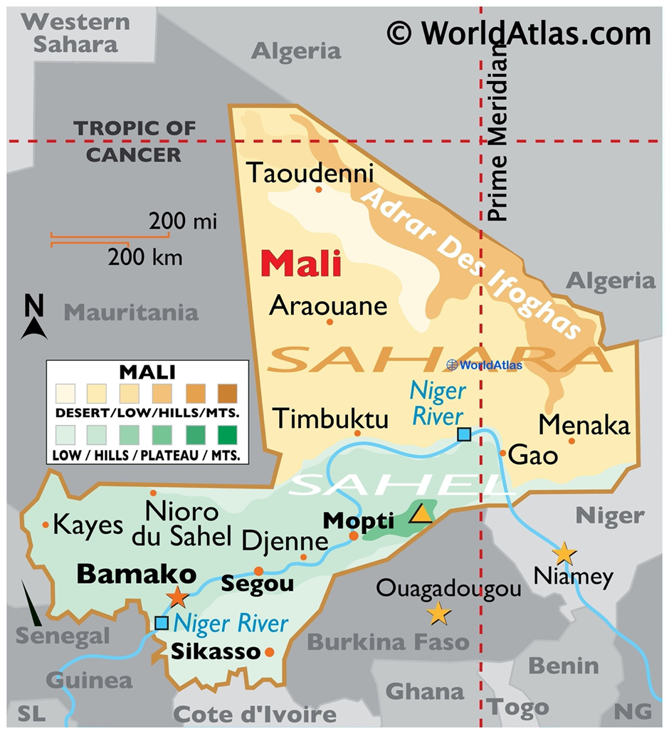
- Location and Geographical Significance:
- Mali is a landlocked country in West Africa, bordered by Algeria to the north, Niger to the east, Burkina Faso and Côte d'Ivoire to the south, Guinea to the southwest, and Senegal and Mauritania to the west.
- The country spans the Sahara Desert in the north, transitioning into the Sahel region in the central part and savanna grasslands in the south.
- The Niger River, one of West Africa’s most significant waterways, flows through Mali, supporting agriculture, fishing, and trade.
- Its capital is Bamako, which is located in the southwestern part of the country.
- Natural Resource Potential:
- Mali is rich in natural resources, particularly gold, making it Africa’s third-largest gold producer after South Africa and Ghana.
- Gold mining contributes significantly to the country’s economy, accounting for about 75% of export revenues.
- Other mineral resources include bauxite, iron ore, phosphate, uranium, and lithium, which have yet to be fully exploited.
- Mali also has vast agricultural potential, particularly in cotton production, but recurring droughts and desertification pose challenges to sustainability.
- Challenges in Gold Mining in the Region:
- Illegal and Artisanal Mining: A significant portion of Mali’s gold production comes from artisanal and small-scale mining (ASM), which operates outside formal regulations, leading to environmental damage and safety concerns.
- Frequent Accidents: Unsafe mining conditions have resulted in fatal accidents, prompting the Malian government to suspend artisanal gold mining permits for foreign companies.
- Environmental Degradation: Gold mining has led to deforestation, water pollution, and land degradation, affecting local communities.
- Security Concerns: Armed groups, including terrorist organisations, exploit gold mining for funding, particularly in the northern and central regions, where government control is weak.
- Economic Exploitation: Foreign mining companies dominate the sector, leading to concerns that local communities do not benefit adequately from mining revenues.
|
UPSC CSE PYQs Q1. Which one of the following ancient towns is well known for its elaborate system of water harvesting and management by building a series of dams and channelling water into connected reservoirs?
Answer: Option A |
|
Also Read |
|
UPSC Foundation Course |
|
| UPSC Monthly Magazine | CSAT Foundation Course |


Yala Glacier Declared Dead – Climate Change & Himalayan Cryosphere
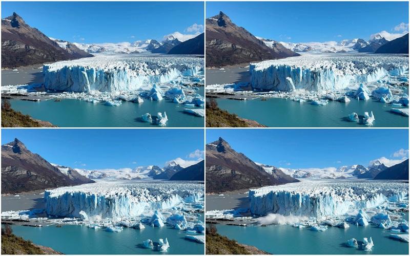
Perito Moreno Glacier Retreat – A Stable Giant Now in Decline
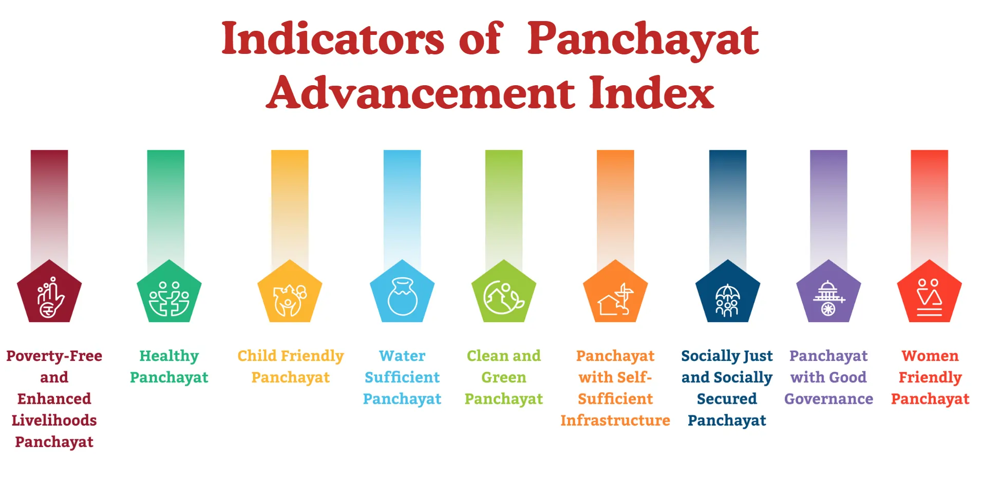
Panchayat Advancement Index (PAI) : Using Local Data for Better Governance
Karol Bagh Metro Pillar No. 112, Above Domino's, 22B, First Floor, New Delhi - 110060
Very Important Instruction For Any Issue, Student Must Produce His/Her Fee Receipt. Without Fee Receipt, It Will Not Be Possible To Track Your Details. If You Have Been Given Any Special Consideration, You Must Keep That In Writing And Produce In Case Of Conflict.
Copyright © 2024-2026 ENSURE IAS. All rights reserved.