- Courses
- GS Full Course 1 Year
- GS Full Course 2 Year
- GS Full Course 3 Year
- GS Full Course Till Selection
- Answer Alpha: Mains 2025 Mentorship
- MEP (Mains Enrichment Programme) Data, Facts
- Essay Target – 150+ Marks
- Online Program
- GS Recorded Course
- Polity
- Geography
- Economy
- Ancient, Medieval and Art & Culture AMAC
- Modern India, Post Independence & World History
- Environment
- Governance
- Science & Technology
- International Relations and Internal Security
- Disaster Management
- Ethics
- NCERT Current Affairs
- Indian Society and Social Issue
- NCERT- Science and Technology
- NCERT - Geography
- NCERT - Ancient History
- NCERT- World History
- NCERT Modern History
- CSAT
- 5 LAYERED ARJUNA Mentorship
- Public Administration Optional
- ABOUT US
- OUR TOPPERS
- TEST SERIES
- FREE STUDY MATERIAL
- VIDEOS
- CONTACT US
PLACES IN NEWS 5th JULY 2025
PLACES IN NEWS 5th JULY 2025

1. Argentina
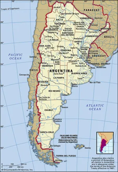
Why in the News?
- Prime Minister Narendra Modi has landed in Buenos Aires, Argentina, marking a historic bilateral visit, the first such trip by an Indian prime minister in 57 years, since Indira Gandhi’s 1968 visit.
- This two day mission is the third stop on his five-nation tour, following visits to Ghana and Trinidad & Tobago.
What are the Key Highlights?
- Geographical Overview:
|
Feature |
Description |
|
Continent |
South America |
|
Latitude/Longitude |
Approximately 23°S to 55°S latitude |
|
Borders |
Chile (west), Bolivia & Paraguay (north), Brazil & Uruguay (northeast), Atlantic Ocean (east) |
|
Length (N-S) |
Approximate 3,650 km, one of the longest north-south countries in the world |
|
Capital |
Buenos Aires (on the eastern coast, on the Río de la Plata estuary) |
- Physical Geography:
- Andes Mountains (Western Argentina):
- Forms the natural boundary with Chile.
- Includes Aconcagua (6,961 m), highest mountain in the Americas.
- Significant for glacial water sources, tourism, and minerals.
- Patagonia (South Argentina):
- Cold desert and steppe region, includes plains and plateaus.
- Sparsely populated.
- Important for oil, gas, and sheep rearing.
- Home to Perito Moreno Glacier (a UNESCO World Heritage Site).
- Pampas (Central Argentina):
- Fertile plains known for extensive agriculture and cattle ranching.
- Argentina is one of the world's leading exporters of beef, soybeans, and wheat.
- Gran Chaco (North Argentina):
- Semi-arid lowland region.
- Rich in biodiversity but threatened by deforestation.
- Home to indigenous communities.
- Mesopotamia Region (Northeast):
- Between Paraná and Uruguay Rivers.
- Rich in forests and wetlands.
- Includes Iguazú Falls (UNESCO site, shared with Brazil).
- Andes Mountains (Western Argentina):
- Hydrology and Rivers:
|
River |
Significance |
|
Parana River |
Second-longest in South America, major for navigation and hydroelectric power (Itaipu Dam nearby) |
|
Uruguay River |
Eastern border with Uruguay |
|
Rio de la Plata |
Estuary formed by confluence of Paraná and Uruguay rivers, Buenos Aires lies on its banks |
|
Colorado & Negro Rivers |
Important in southern irrigation and hydroelectricity |
- Important Places:
|
Place |
Why Important |
|
Buenos Aires |
Capital, port city, political & economic hub |
|
Mendoza |
Near Andes, wine production & Aconcagua mountain base |
|
Cordoba |
Industrial & educational center |
|
Rosario |
Major port on Parana River, agriculture hub |
|
Ushuaia |
Southernmost city in the world, gateway to Antarctica |
|
Iguazu Falls |
World-famous waterfall, UNESCO heritage site |
|
Falkland Islands (UK territory, claimed by Argentina) |
Geopolitical hotspot |
|
Tierra del Fuego |
Archipelago shared with Chile; end of the mainland |
- Other Important Information
- South-South Cooperation:
- Argentina is a part of the Global South, and India-Argentina ties are increasing in space tech, pharmaceuticals, agriculture, and lithium.
- Lithium Triangle:
- Argentina, Bolivia, Chile form the Lithium Triangle — key for EV batteries.
- Climate & Biodiversity:
- Large latitudinal extent = varied ecosystems.
- Important examples for biogeography, climate zones, and conservation issues.
- Antarctica Connection:
- Ushuaia was used as a base for Antarctica expeditions.
- South-South Cooperation:
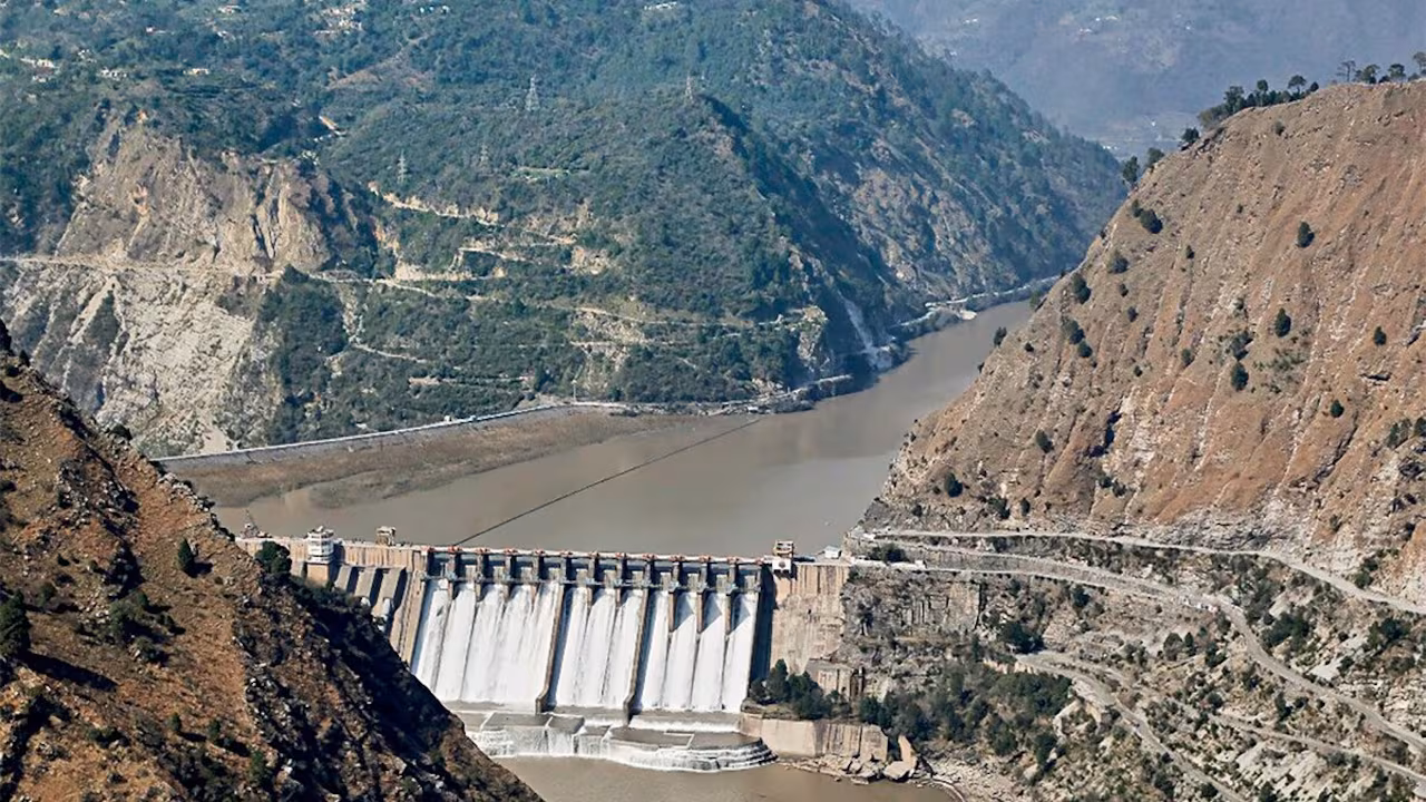
2. Siang Upper Multipurpose Project
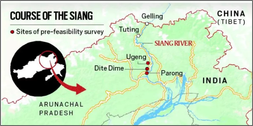
Why in the News?
- The Siang Upper Multipurpose Storage Project, located in Arunachal Pradesh, has gained attention due to:
- Geopolitical concerns over China's dam-building upstream on the Yarlung Tsangpo (Brahmaputra).
- Potential for hydropower generation, flood control, and water storage.
- Concerns about ecological impacts and displacement of tribal populations.
Geographical Location:
|
Aspect |
Details |
|
River |
Siang River (main stem of the Brahmaputra in Arunachal Pradesh) |
|
State |
Arunachal Pradesh |
|
Districts Covered |
Upper Siang District |
|
Upstream Origin |
Yarlung Tsangpo in Tibet, enters India as Siang |
|
Downstream Confluence |
Merges with Dibang and Lohit rivers to form Brahmaputra in Assam |
|
Nearby Important Towns |
Yingkiong, Tuting
|
|
Coordinates (Approx.) |
Latitude: ~28.5° N, Longitude: ~95.0° E |
|
Topography |
Located in Eastern Himalayas, rugged terrain, deep gorges, and forested valleys
|
Project Features:
|
Parameter |
Details |
|
Type |
Multipurpose Storage Project |
|
Components |
Hydropower, irrigation, flood moderation, water storage |
|
Proposed Dam Height |
Over 280 metres (One of the tallest in India) |
|
Capacity |
Estimated hydropower generation of 11,000 MW+ |
|
Authority |
NHPC Ltd. (or relevant Central PSU) |
|
Status |
Under appraisal / planning stage |
Objectives:
- Hydropower generation for the North-East and national grid.
- Flood control downstream in Assam.
- Strategic water storage against China's upstream dams.
- Irrigation and drinking water for downstream regions.
Environmental and Social Concerns:
|
Issue |
Details |
|
Displacement |
Large-scale displacement of Adi and other tribal communities. |
|
Biodiversity |
Located in the Eastern Himalayas—a biodiversity hotspot with rare flora & fauna. |
|
Seismic Zone |
High seismic activity—Earthquake-prone area (Zone V). |
|
Cultural Sites |
Close to indigenous sacred sites and tribal heritage zones. |
|
Deforestation |
Risk of submergence of large forest areas. |
Strategic & Geopolitical Relevance
- Counters Chinese hydropower projects on upstream Yarlung Tsangpo.
- Acts as India’s strategic water buffer.
- Ensures river flow regulation for downstream Assam and Bangladesh.
- Tied to India’s “Act East” Policy and Northeast infrastructure development.

Indus Waters Treaty Under Climate and Security Stress

Echoes of Tyranny in Democracies

CJI Vows Transparency in Collegium Appointments
Karol Bagh Metro Pillar No. 112, Above Domino's, 22B, First Floor, New Delhi - 110060
Very Important Instruction For Any Issue, Student Must Produce His/Her Fee Receipt. Without Fee Receipt, It Will Not Be Possible To Track Your Details. If You Have Been Given Any Special Consideration, You Must Keep That In Writing And Produce In Case Of Conflict.
Copyright © 2024-2026 ENSURE IAS. All rights reserved.