- Courses
- GS Full Course 1 Year
- GS Full Course 2 Year
- GS Full Course 3 Year
- GS Full Course Till Selection
- Answer Alpha: Mains 2025 Mentorship
- MEP (Mains Enrichment Programme) Data, Facts
- Essay Target – 150+ Marks
- Online Program
- GS Recorded Course
- Polity
- Geography
- Economy
- Ancient, Medieval and Art & Culture AMAC
- Modern India, Post Independence & World History
- Environment
- Governance
- Science & Technology
- International Relations and Internal Security
- Disaster Management
- Ethics
- NCERT Current Affairs
- Indian Society and Social Issue
- NCERT- Science and Technology
- NCERT - Geography
- NCERT - Ancient History
- NCERT- World History
- NCERT Modern History
- CSAT
- 5 LAYERED ARJUNA Mentorship
- Public Administration Optional
- ABOUT US
- OUR TOPPERS
- TEST SERIES
- FREE STUDY MATERIAL
- VIDEOS
- CONTACT US
PLACES IN NEWS 30th June 2025
PLACES IN NEWS 30th June 2025
30-06-2025

1. Kolhapur
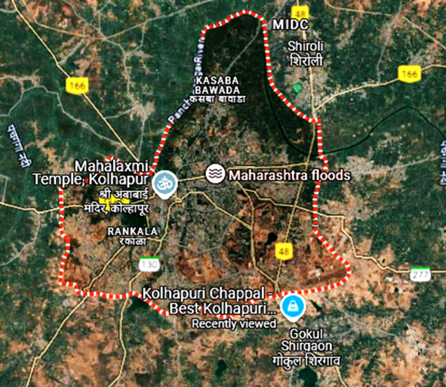
Why in the News?
- Italian luxury fashion brand Prada showcased sandals in its 2026 spring-summer men’s collection that look very similar to Kolhapuri chappals — a traditional Indian footwear. These slippers have been part of Indian culture for centuries and are made by skilled artisans.
- The Kolhapuri chappals also have a Geographical Indication (GI) tag, which means they are legally recognized as a product linked to a specific place in India. Many chappal makers now accuse Prada of copying their design without giving credit or asking for permission.
What are the Key Highlights?
- State: Maharashtra
- Region: Western Maharashtra (also called Paschim Maharashtra)
- Coordinates: Between 16.40°N to 17.10°N latitude and 73.40°E to 74.40°E longitude
- Boundaries:
- North: Sangli district
- East: Belgaum district (Karnataka)
- South: Sindhudurg district
- West: Ratnagiri district
- Area and Terrain:
- Total Area: Around 7,685 sq. km
- Terrain:
- Mainly undulating plateau and fertile valleys
- Lies in the rain-shadow area of the Western Ghats
- Partly covered by Sahyadri hills on the west
- Rivers:
- Major river is the Panchganga, which is a tributary of the Krishna River.
- Other rivers include Dudhganga, Vedganga, Warna, and Bhogawati
- Climate:
- Type: Tropical monsoon
- Rainfall: Moderate to heavy, especially in hilly areas
- Temperature:
- Summer: 25°C to 40°C
- Winter: 14°C to 30°C
- Economy and Industry:
- Agriculture:
- Main crops: Sugarcane, rice, jaggery, groundnut, soybean
- Known as one of the major sugar-producing districts of Maharashtra
- Industry:
- Famous for Kolhapuri chappals, textiles, sugar mills, and foundry units
- Industrial areas include Shiroli MIDC, Gokul Shirgaon, and Kagal Five Star MIDC
- Agriculture:
- Culture and Heritage:
- Famous for:
- Kolhapuri chappals (with GI tag)
- Kolhapuri cuisine (like Tambada and Pandhara Rassa)
- Mahalakshmi Temple – a major Hindu pilgrimage site
- Languages: Marathi (main), along with Kannada in some border areas
- Festivals: Navratri, Mahalaxmi Yatra, Ganesh Chaturthi
- Famous for:
- Transport and Connectivity:
- Road: Well-connected by national and state highways (NH-48 passes through)
- Rail: Kolhapur railway station (C Shahumharaj Terminus) links to Mumbai, Pune, Bengaluru
- Air: Kolhapur Airport (Ujalaiwadi)currently being expanded for better domestic connectivity
- Environmental and Ecological Aspects:
- Part of Western Ghats Ecosystem, a UNESCO World Heritage site
- Includes protected areas like:
- Radhanagari Wildlife Sanctuary
- Dajipur Bison Sanctuary
- Rich in biodiversity and home to species like Indian bison (gaur), leopards, deer, and various birds.
2. Kailash Mansarovar
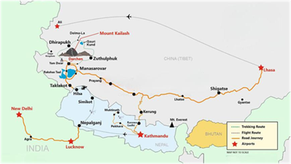
Why in the news?
- The first batch of Indian pilgrims since 2020 has undertaken the Kailash Mansarovar Yatra, marking the resumption of the pilgrimage after a 6-year gap caused by the COVID-19 pandemic and India-China border tensions.
- The group visited Mount Kailash and Mansarovar Lake in the Tibet Autonomous Region of China and is scheduled to return to India on July 1, 2025.
- Pilgrims have appealed to India and China to increase the number of yatra slots, allowing more people to experience the spiritual journey.
- The yatra also signifies a positive development in people-to-people relations between India and China amidst continued military standoff at the Line of Actual Control (LAC).
Geographical Location
- Mount Kailash and Lake Mansarovar are located in the Tibet Autonomous Region (TAR) of China, near the source of some of Asia's major rivers.
- They lie north of the Himalayas, near the western part of Tibet, close to the borders with India (Uttarakhand) and Nepal.
Mount Kailash
- Height: Approx. 6,638 metres (21,778 feet).
- Considered sacred in four religions: Hinduism, Buddhism, Jainism, and Bon(Tibetan indigenous religion).
- Hindus believe it to be the abode of Lord Shiva.
- Buddhists regard it as the home of Demchok (Chakrasamvara).
- Jains believe their first Tirthankara, Rishabhdev, attained nirvana here.
- Parikrama (circumambulation): Pilgrims walk ~52 km around the mountain, usually taking 3 days.
Lake Mansarovar
- Height: 4,588 metres (15,049 feet) — one of the highest freshwater lakes in the world.
- Surface Area: About 412 sq. km.
- Mythological significance: Believed in Hinduism to have been created by Lord Brahma. Bathing in its water is said to cleanse sins and bring salvation.
- Connected to Rakshastal (a nearby saline lake) by a short channel, symbolizing the duality of good and evil.
Access and Routes
- There are two main pilgrimage routes from India:
- Lipulekh Pass (via Uttarakhand) – older and more traditional route.
- Nathu La Pass (via Sikkim) – added in 2015, more motorable and less physically strenuous.
- Both routes are coordinated by the Ministry of External Affairs (MEA), Government of India, and involve significant trekking and high-altitude travel.
Major Rivers Originating Near Mount Kailash and Lake Mansarovar
- Indus River (Sênggye Tsangpo in Tibet)
- Originates north of Mount Kailash.
- Flows northwest through Tibet, enters Ladakh in India, and continues into Pakistan.
- One of the longest rivers in Asia (approx. 3,180 km).
- Sutlej River (Langqên Zangbo)
- Rises west of Lake Rakshastal, close to Mount Kailash.
- Flows through Himachal Pradesh and joins the Indus in Pakistan.
- Crucial for irrigation and hydro projects.
- Brahmaputra River (Yarlung Tsangpo)
- Originates near Mount Kailash and Lake Mansarovar.
- Flows eastward across Tibet, known as Yarlung Tsangpo, enters Arunachal Pradesh, India, and becomes Brahmaputra.
- Merges with the Ganga in Bangladesh as the Jamuna.
- Karnali River (Ghaghara in India)
- Starts south of Lake Mansarovar.
- Major river of western Nepal, becomes Ghaghara in Uttar Pradesh.
- Important tributary of the Ganga River.
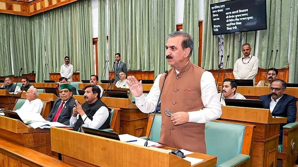
Anti-Defection Law Averts Political Crisis in Himachal Pradesh

Ensuring Safe Cancer Drugs is a Global Challenge
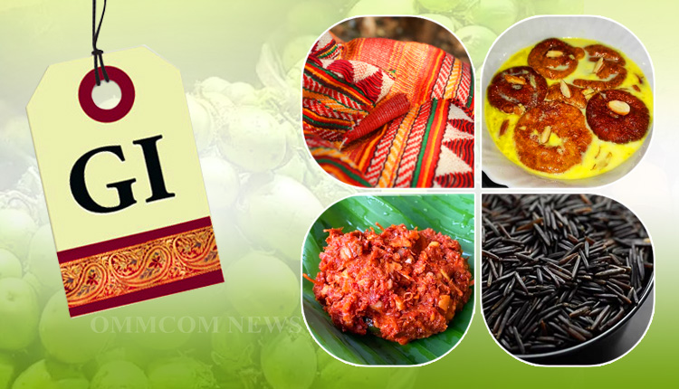
G.I. Tags: Cultural Shield or Just a Label?
Karol Bagh Metro Pillar No. 112, Above Domino's, 22B, First Floor, New Delhi - 110060
Very Important Instruction For Any Issue, Student Must Produce His/Her Fee Receipt. Without Fee Receipt, It Will Not Be Possible To Track Your Details. If You Have Been Given Any Special Consideration, You Must Keep That In Writing And Produce In Case Of Conflict.
Copyright © 2024-2026 ENSURE IAS. All rights reserved.