- Courses
- GS Full Course 1 Year
- GS Full Course 2 Year
- GS Full Course 3 Year
- GS Full Course Till Selection
- Online Program
- GS Recorded Course
- NCERT (Recorded 500+ Hours)
- Polity Recorded Course
- Geography Recorded Course
- Economy Recorded Course
- AMAC Recorded Course
- Modern India, Post Independence & World History
- Environment Recoded Course
- Governance Recoded Course
- Science & Tech. Recoded Course
- International Relations and Internal Security Recorded Course
- Disaster Management Module Course
- Ethics Recoded Course
- Essay Recoded Course
- Current Affairs Recoded Course
- CSAT
- 5 LAYERED ARJUNA Mentorship
- Public Administration Optional
- ABOUT US
- OUR TOPPERS
- TEST SERIES
- FREE STUDY MATERIAL
- VIDEOS
- CONTACT US
PLACES IN NEWS 22nd MARCH 2025
PLACES IN NEWS 22nd MARCH 2025
22-03-2025

Jim Corbett Tiger Reserve
Why in news?
- The Supreme Court criticized the Uttarakhand government for its slow action against senior officials accused of illegal constructions in Jim Corbett Tiger Reserve.
About Jim Corbett Tiger Reserve:
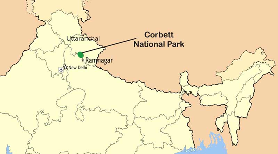
- Location and Geography:
- Jim Corbett Tiger Reserve is located in the foothills of the Himalayas in Uttarakhand.
- It spans 1,288.31 sq. km, covering undulating terrain with valleys, riverine belts, and grasslands.
- The reserve is traversed by the Ramganga, Pallaen, and Sonanadi rivers, which sustain its rich biodiversity.
- The landscape primarily consists of Bhabar and lower Shivalik regions, featuring porous tracts with boulders and sand deposits.
- Flora and Fauna:
- The reserve hosts Sal and mixed forests, along with extensive grasslands (Chaur), which resulted from abandoned settlements.
- The dominant tree species include Sal, Sheesham, and Kanju, while Lantana, an invasive weed, poses ecological challenges.
- Tigers and elephants are the flagship species, alongside leopards, sambar, hog deer, and spotted deer.
- The reserve is also home to gharials, crocodiles, numerous bird species, and diverse fish populations, enhancing its ecological significance.
- Illegal Construction in the Region:
- Unauthorized buildings have been constructed within protected areas, violating environmental norms and disrupting wildlife habitats.
- Senior government officials have been accused of allowing illegal resorts and structures, leading to legal scrutiny and Supreme Court intervention.
Mount Lewotobi
Why in news?
- Indonesia's Lewotobi Laki-laki volcano erupted, prompting authorities to cancel some Bali flights due to ash clouds and aviation safety concerns.
About Mount Lewotobi:
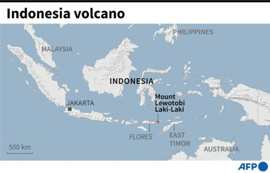
- Location and Features:
- Mount Lewotobi is a twin stratovolcano located in East Flores Regency, Indonesia, on the eastern end of Flores Island.
- It consists of two volcanic peaks: Lewotobi Laki-laki ("Male Lewotobi") and Lewotobi Perempuan ("Female Lewotobi"), both active and known for frequent eruptions.
- The surrounding region features dense forests, steep slopes, and fertile volcanic soil, supporting agriculture and human settlements.
- Lewotobi is part of Indonesia’s Sunda Arc, a chain of volcanoes formed due to subduction of the Indo-Australian Plate beneath the Eurasian Plate.
- Reason Behind the Eruption and Past Eruptions:
- The eruption of Lewotobi Laki-laki was triggered by magma movement and gas build-up beneath the Earth’s crust, causing ash plumes and potential lava flows.
- Indonesia lies on the Pacific Ring of Fire, making it highly prone to volcanic activity due to constant tectonic movements.
- Past eruptions of Lewotobi have been recorded multiple times, including significant eruptions in 1921, 1935, and 2003, often affecting nearby communities.
- The latest eruption led to ash clouds disrupting flights in Bali, highlighting its impact on regional air travel and public safety.
- The region’s volcanic activity contributes to fertile land but also poses risks like earthquakes, tsunamis, and eruptions, affecting local populations.
Laokhowa-Burhachapori Wildlife Sanctuary
Why in news?
- A sniffer dog was deployed in Assam's Laokhowa-Burhachapori Wildlife Sanctuary to help combat wildlife crimes like poaching and illegal trafficking.
About Laokhowa-Burhachapori Wildlife Sanctuary:
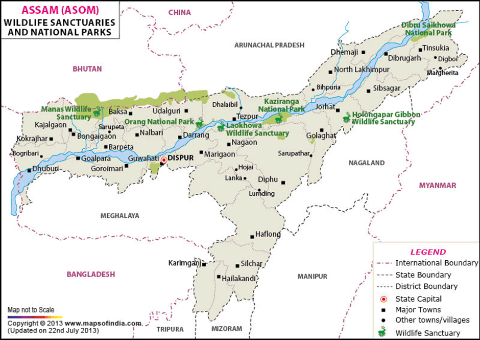
- Location:
- Laokhowa-Burhachapori Wildlife Sanctuary is located in Nagaon district, Assam, covering 70.13 sq. km on the southern bank of the Brahmaputra River.
- It forms part of the Laokhowa-Burhachapori ecosystem, an important corridor for wildlife movement.
- The sanctuary experiences a subtropical monsoon climate, with distinct wet and dry seasons affecting vegetation and animal behaviour.
- Flora and Fauna:
- The sanctuary consists of grasslands, wetlands, and swampy forests, providing an ideal habitat for herbivores and water-dependent species.
- It was once home to over 70 Indian rhinos, but rampant poaching in the 1980s led to their local extinction.
- Key species include Asiatic water buffaloes, Bengal tigers, leopards, wild boars, hog deer, and leopard cats.
- Over 200 bird species, including migratory birds, make it a significant birdwatching site.
- Wildlife Crimes in the Region:
- Poaching and Illegal Hunting: Laokhowa-Burhachapori Wildlife Sanctuary has witnessed rampant poaching of Indian rhinos, leading to their local extinction in the 1980s. Other species like Asiatic water buffaloes and deer are also targeted.
- Smuggling and Illegal Trade: The region is vulnerable to wildlife trafficking, with animal parts like rhino horns, tiger skins, and ivory being illegally traded.
- Encroachment and Habitat Destruction: Illegal settlements, cattle grazing, and deforestation threaten the sanctuary, reducing space for wildlife and increasing human-animal conflicts.
Sahara Desert
Why in news?
- Unusual storms in the Sahara Desert caused heavy rainfall, leading to the formation of temporary lakes in the arid landscape.
About Sahara Desert:
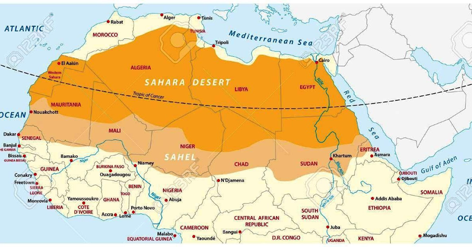
- Location and Features:
- The Sahara Desert is the largest hot desert in the world, spanning North Africa across 11 countries, including Algeria, Egypt, Libya, Chad, Mali, and Sudan.
- It covers approximately 9.2 million square kilometres, making it almost as large as the United States.
- The Sahara is characterised by vast sand dunes, rocky plateaus, gravel plains, dry valleys, and salt flats.
- It has an arid climate, with daytime temperatures exceeding 50°C and nights dropping to near freezing.
- Formation of the Sahara Desert:
- The Sahara was not always a desert; around 10,000 years ago, it was a lush green landscape with lakes, rivers, and abundant wildlife.
- The shift from a wet climate to extreme aridity occurred due to changes in the Earth’s orbit and axial tilt, altering monsoon patterns.
- Over thousands of years, reduced rainfall and increased evaporation transformed the region into the arid desert seen today.
- Expansion of the Sahara Desert:
- In recent decades, the Sahara has been expanding southward, encroaching on the Sahel region at an estimated rate of 48 kilometres per year.
- Climate change, deforestation, and unsustainable agricultural practices have accelerated desertification, reducing arable land and affecting millions of people.
- Countries like Niger, Chad, and Sudan are experiencing water shortages, crop failures, and displacement of communities due to this expansion.
- Unusual Storms and Formation of Temporary Lakes
- Scientists have observed that rare, intense storms in the Sahara occasionally lead to the formation of temporary lakes, challenging the idea that the desert is completely dry.
- A study conducted in north-western Algeria focused on Sebkha el Melah, a normally dry lakebed that temporarily fills with water after extreme rainfall.
- Satellite data from 2000 to 2021 identified only six significant lake-filling events (LFEs), showing that such lakes form only after exceptionally powerful storms.
- Causes of These Rare Storms
- Extratropical cyclones from the Atlantic Ocean are a key factor, bringing moisture-rich air into the desert.
- Instead of being blocked by the Atlas Mountains, some storms manage to bypass the rain shadow effect, delivering heavy precipitation into low-lying desert basins.
- Slow-moving Cyclones contribute to longer, more intense rainfall, increasing the likelihood of lake formation.
6. Implications for Climate Change and Future Patterns
- Climate models suggest that rising global temperatures may increase the frequency and intensity of storms in the Sahara.
- More frequent flooding events could provide temporary relief to water-scarce regions, though they won’t transform the desert into a permanent wetland.
- Understanding these rare events is crucial for predicting future climate shifts and assessing how desert ecosystems and human populations may adapt to changing rainfall patterns.
Ganga River
Why in news?
- Uttarakhand Chief Minister announces plans to develop corridors along Ganga, Sharda rivers, to boost tourism.
About Ganga River:
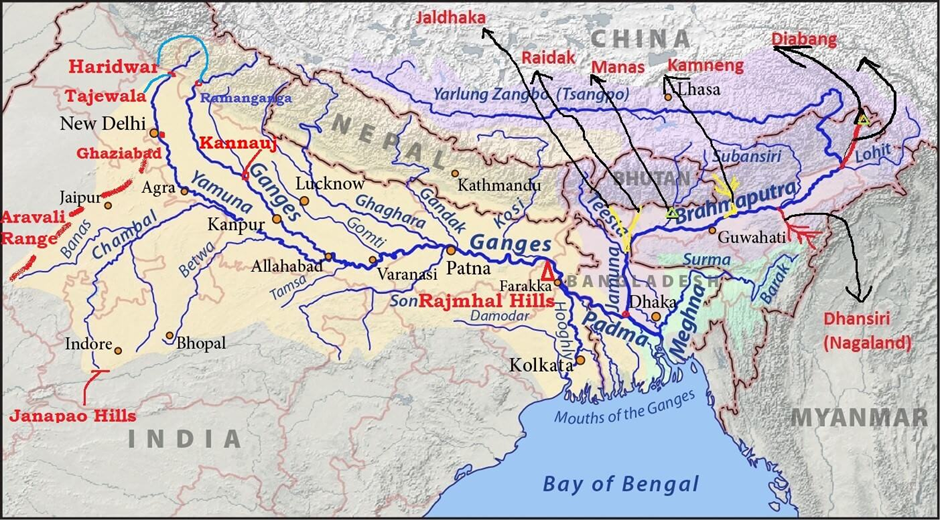
- Origin and Course:
- The Ganga River originates from the Gangotri Glacier in the Himalayas at Gaumukh, Uttarakhand, at an elevation of 3,892 meters.
- The Bhagirathi, the primary source, merges with the Alaknanda at Devprayag, forming the Ganga.
- It traverses five states: Uttarakhand, Uttar Pradesh, Bihar, Jharkhand, and West Bengal, covering approximately 2,525 km.
- The river bifurcates at Farakka, with the Padma flowing into Bangladesh and the Hooghly flowing into the Bay of Bengal.
- Tributaries:
- Major right-bank tributaries: Yamuna, Son, Punpun, and Damodar.
- Major left-bank tributaries: Ramganga, Gomti, Ghaghara, Gandak, Kosi, and Mahananda.
- Ecological and Cultural Significance:
- The Ganga basin supports about 40% of India’s population, playing a crucial role in agriculture, industry, and livelihoods.
- It holds immense religious significance in Hinduism, with sacred sites like Haridwar, Varanasi, and Prayagraj along its course.
- The riverine ecosystem supports diverse flora and fauna, including the endangered Ganges river dolphin and gharial.
- Pollution and Conservation Efforts:
- The Ganga faces severe pollution due to industrial waste, sewage discharge, and religious activities.
- Key pollutants include heavy metals, untreated sewage, and plastic waste.
- Conservation initiatives include the Namami Gange Programme, aimed at sewage treatment, river surface cleaning, and afforestation.
- The National Mission for Clean Ganga (NMCG) oversees river rejuvenation projects, promoting bio-remediation and public participation.
- Various court rulings and environmental activism have emphasised sustainable river management and pollution control.
About Sharda River
- Origin and Course:
- The Sharda River originates as the Kali (Mahakali) River from the Great Himalayas in Uttarakhand, at an elevation of 3,600 meters.
- It forms part of the India-Nepal border before entering the Indo-Gangetic Plain at Brahmadev Mandi in Nepal.
- It flows southeastward into Uttar Pradesh and merges with the Ghaghara River southwest of Bahraich, covering approximately 480 km.
- Irrigation and Hydroelectric Projects:
- The Sharda Barrage (Upper Sharda Barrage), constructed in the 1920s, is crucial for irrigation in Uttar Pradesh.
- The Tanakpur Hydroelectric Project (120 MW), commissioned in 1993, utilises the river’s flow for power generation.
- The Pancheshwar Multipurpose Project (PMP), a joint India-Nepal venture, aims to generate 5,600 MW of hydroelectric power and enhance irrigation.
- Other Key Facts:
- The Mahakali Treaty (1996) governs the integrated development of the Sharda River between India and Nepal, ensuring equitable water use.
- The river receives major tributaries like Darma, Gori Ganga, Sarju, and Ladhiya, contributing to its flow.
- The Sharda River is also considered for India’s River Inter-linking Project, aimed at optimising water resources for irrigation and drinking purposes.
- The river plays a vital role in the Terai region’s ecosystem, supporting agriculture, fisheries, and biodiversity conservation.
|
UPSC CSE PYQs Q1. With reference to the Himalayan rivers Joining the Ganga downstream of Prayagraj from West to East, which one of the following sequences is correct? (2024)
Answer: Option B
|
|
Also Read |
|
| Public Administration Optional | |
| UPSC Monthly Magazine | Question Answer Practice For UPSC |


Share of Gold in India’s Forex Reserves

Supreme Court Publishes Declaration of Judges' Assets
MHA Organizes Civil Defence Exercise
Karol Bagh Metro Pillar No. 112, Above Domino's, 22B, First Floor, New Delhi - 110060
Copyright © 2024-2026 ENSURE IAS. All rights reserved.