- Courses
- GS Full Course 1 Year
- GS Full Course 2 Year
- GS Full Course 3 Year
- GS Full Course Till Selection
- Answer Alpha: Mains 2025 Mentorship
- MEP (Mains Enrichment Programme) Data, Facts
- Essay Target – 150+ Marks
- Online Program
- GS Recorded Course
- Polity
- Geography
- Economy
- Ancient, Medieval and Art & Culture AMAC
- Modern India, Post Independence & World History
- Environment
- Governance
- Science & Technology
- International Relations and Internal Security
- Disaster Management
- Ethics
- NCERT Current Affairs
- Indian Society and Social Issue
- NCERT- Science and Technology
- NCERT - Geography
- NCERT - Ancient History
- NCERT- World History
- NCERT Modern History
- CSAT
- 5 LAYERED ARJUNA Mentorship
- Public Administration Optional
- ABOUT US
- OUR TOPPERS
- TEST SERIES
- FREE STUDY MATERIAL
- VIDEOS
- CONTACT US
PLACES IN NEWS 1st JULY 2025
PLACES IN NEWS 1st JULY 2025
01-07-2025

1. Kishanganga Hydropower Project
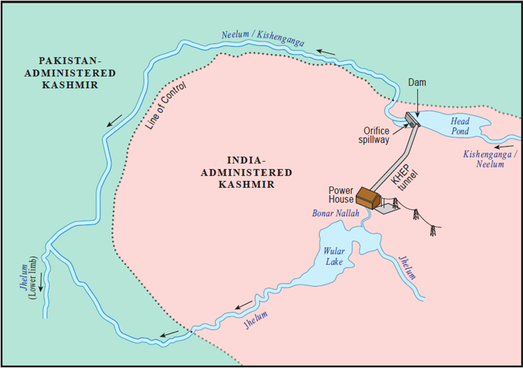
Why in the News?
- India has strongly rejected a recent "supplemental award" issued by the Court of Arbitration regarding the Kishanganga hydroelectric projects in Jammu and Kashmir.
- India said the Court has no legal standing and that it violated the Indus Waters Treaty (IWT), which India has now suspended after a terror attack in April 2025.
What are the Key Highlights?
- Location
- Country: India
- Union Territory: Jammu and Kashmir
- District: Bandipora
- Nearest Town: Bandipora town
- Village near dam site: Kralpora village, Gurez Valley
- River System
- River: Kishanganga River (called Neelum River in Pakistan)
- Tributary of: Jhelum River
- River Origin: Originates in the Drass sector of the Himalayas near the Line of Control (LoC)
- River Path: Flows through Gurez Valley (India) → Crosses LoC → Enters Pakistan-administered Kashmir → Joins Jhelum River at Muzaffarabad
- Coordinates
- Approximate Latitude: 34.63° N
- Approximate Longitude: 74.78° E
- Topography and Terrain
- Located in high Himalayan mountain region
- Terrain is rugged and mountainous
- Project elevation ranges between 1,650 to 2,000 metres above sea level
- Water Diversion and Infrastructure
- Water is diverted through a 23.5 km headrace tunnel from the Kishanganga River to a power station located near Bonar Nallah, a tributary of the Jhelum River
- Includes a 37-metre-high concrete-face rock-fill dam
- The water after power generation is discharged into the Jhelum basin
- Hydrological Zone
- Lies within the Western Himalayan hydrological region
- Receives water primarily from glacial melt and seasonal snowfall, making it a perennial river
- Accessibility
- Due to mountainous terrain and heavy snowfall, the region remains inaccessible during peak winter
- The project site is connected to Bandipora via a mountain road, which is sometimes affected by landslides and snow
- Strategic Location
- Located very close to the Line of Control (LoC) between India and Pakistan
- The area is geopolitically sensitive due to its proximity to the LoC and shared river system with Pakistan
2. Mullaperiyar Dam
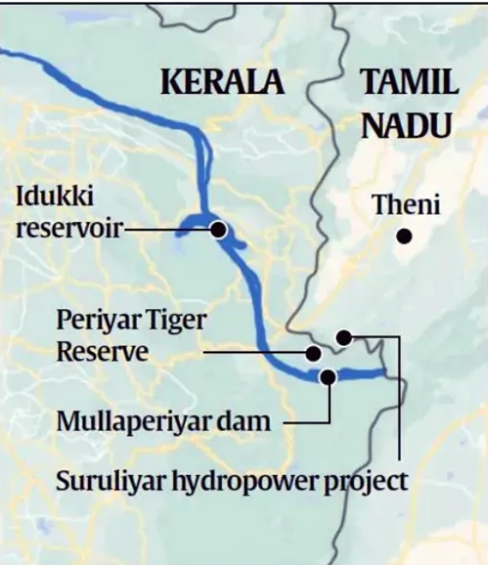
Why in the News?
- Tamil Nadu released water from the Mullaperiyar dam by opening all 13 spillway shutters.
- It happened after the water level exceeded the rule curve (136.4 ft against 136.3 ft), highlighting interstate water management dynamics.
- 999-Year Lease Agreement Highlighted: The incident brought attention back to the unique colonial-era lease agreement under which Tamil Nadu operates the dam.
- The Idukki reservoir, downstream in Kerala, recorded significantly higher water storage this year (June 2025) compared to the same period last year.
- It is an important indicator in monsoon-related dam management and hydroelectric planning.
About Mullaperiyar Dam
- Location: The Mullaperiyar Dam is located in the Cardamom Hills of the Western Ghats, near Kumily, on the Kerala-Tamil Nadu border in Idukki district.
- Construction: Completed in 1895, the dam was built using a mix of limestone and Surkhi.
- It diverts water from Kerala’s Periyar River to Tamil Nadu’s Vaigai basin to meet irrigation and drinking water needs.
- Significance: The dam is vital for supplying water to southern districts of Tamil Nadu for both agriculture and domestic use.
- Inter-State Dispute: It has been a subject of long-standing disagreement between Kerala and Tamil Nadu, mainly over issues related to safety and control of its operations.


PLACES IN NEWS 2nd JULY 2025

10 Years of Digital India Scheme

Digital Transformation in Women and Child Development
Karol Bagh Metro Pillar No. 112, Above Domino's, 22B, First Floor, New Delhi - 110060
Very Important Instruction For Any Issue, Student Must Produce His/Her Fee Receipt. Without Fee Receipt, It Will Not Be Possible To Track Your Details. If You Have Been Given Any Special Consideration, You Must Keep That In Writing And Produce In Case Of Conflict.
Copyright © 2024-2026 ENSURE IAS. All rights reserved.