- Courses
- GS Full Course 1 Year
- GS Full Course 2 Year
- GS Full Course 3 Year
- GS Full Course Till Selection
- Answer Alpha: Mains 2025 Mentorship
- MEP (Mains Enrichment Programme) Data, Facts
- Essay Target – 150+ Marks
- Online Program
- GS Recorded Course
- Polity
- Geography
- Economy
- Ancient, Medieval and Art & Culture AMAC
- Modern India, Post Independence & World History
- Environment
- Governance
- Science & Technology
- International Relations and Internal Security
- Disaster Management
- Ethics
- NCERT Current Affairs
- Indian Society and Social Issue
- NCERT- Science and Technology
- NCERT - Geography
- NCERT - Ancient History
- NCERT- World History
- NCERT Modern History
- CSAT
- 5 LAYERED ARJUNA Mentorship
- Public Administration Optional
- ABOUT US
- OUR TOPPERS
- TEST SERIES
- FREE STUDY MATERIAL
- VIDEOS
- CONTACT US
PLACES IN NEWS 18th JANUARY 2025
PLACES IN NEWS 18th JANUARY 2025

Bharathapuzha river
Why in news?
- Four members of a family tragically drowned in the Bharathapuzha river in Kerala. The incident occurred during a family outing near the riverbank, where strong currents reportedly swept them away.
- Local authorities and rescue teams recovered the bodies after an extensive search. The tragedy has left the community in shock.
About Bharathapuzha river
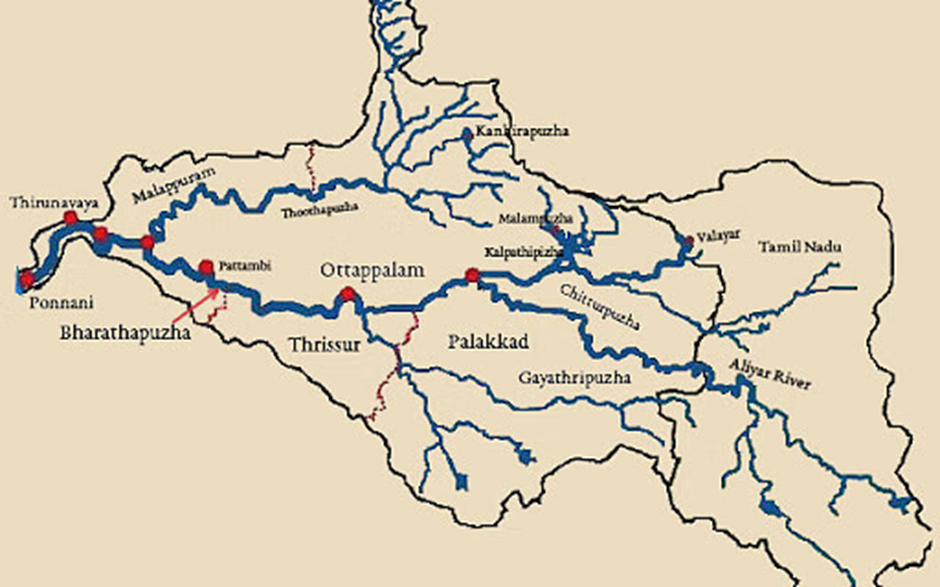
- Origin and path:
- The Bharathapuzha River, also known as the Nila or Ponnani River, is the second longest in Kerala, India, spanning 209 kilometres.
- It originates from the Anamalai Hills in Tamil Nadu at an elevation of 2,461 meters and flows westward through the Palakkad Gap, the largest opening in the Western Ghats within Kerala.
- The river traverses Palakkad and Malappuram districts before emptying into the Lakshadweep Sea at Ponnani.
- Significant Tributaries:
- The Bharathapuzha River is enriched by several significant tributaries that contribute to its flow and ecological importance.
- These include the Thuthapuzha, a vital stream that merges
with the main river, and the Gayathripuzha, known for its scenic beauty and supporting agricultural activities in the region.
- The Kalpathipuzha and Kannadipuzha further enhance the river's volume, playing essential roles in sustaining the biodiversity and livelihoods along their courses.
- Additionally, the Tirur River, though smaller in comparison, adds to the network of waterways that form the lifeline of central Kerala.
- Ecological challenge:
- Despite its extensive basin of 6,186 square kilometres, the Bharathapuzha River experiences relatively low water flow compared to other long rivers in Kerala.
- This is partly because a significant portion of its basin lies in the drier regions of Tamil Nadu and the Palakkad Gap, which receive less rainfall.
- The construction of multiple dams, such as the Malampuzha Dam, Mangalam Dam, and Pothundi Dam, has further reduced the river's flow.
- These dams, while essential for irrigation and water storage, have impacted the natural flow, resulting in minimal water presence during summer months. Consequently, the river often struggles to sustain its ecological and cultural significance during drier periods.
Siachen Glacier
Why in news?
- A private telecom firm in India has successfully brought 4G and 5G services to the Siachen Glacier, the world's highest battlefield.
- This technological milestone aims to enhance connectivity for the Indian Army and support personnel in the remote, challenging terrain.
About Siachen Glacier:
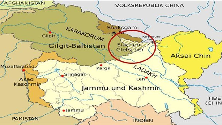
- Location:
- The Siachen Glacier, located in the eastern Karakoram Range in the Himalayas, is one of the world's longest non-polar glaciers, extending approximately 76 kilometres.
- Situated at elevations ranging from 3,620 meters to 5,753 meters, it lies just northeast of the point NJ9842, where the Line of Control between India and Pakistan terminates.
- The glacier feeds the Nubra River, which ultimately merges with the Shyok River, contributing to the Indus River system.
- Ecological importance:
- Ecologically, the Siachen Glacier plays a crucial role in the region's hydrology, acting as a perennial source of freshwater for the rivers it feeds. However, the glacier has been retreating over the past several decades.
- A 2007 survey by the Pakistan Meteorological Department revealed that the glacier has been retreating for the past 30 years at a rate of about 110 meters per year, with its size decreasing by almost 35 percent.
- This retreat is attributed to both global climate change and localised human activities, including military presence. The accumulation of non-biodegradable waste, such as empty ammunition shells and parachutes, has further degraded the glacier's ecosystem.
- Territorial Disputes:
- The Siachen region has been a focal point of territorial disputes between India and Pakistan. The conflict arises from incomplete territorial demarcation beyond the map coordinate known as NJ9842.
- The 1949 Karachi Agreement and the 1972 Shimla Agreement did not clearly define control over the glacier, leading to ambiguity.
- In 1984, India launched Operation Meghdoot, establishing control over the glacier and the adjacent Saltoro Ridge.
- Since then, both nations have maintained a military presence in the area, making it the world's highest battleground.
- The ongoing military activities have not only led to human casualties but have also exacerbated environmental degradation, impacting the glacier's health and the broader ecosystem.
Cabo Verde
Why in news?
The World Bank’s recent report highlights that Cabo Verde, a small archipelago off West Africa’s coast, requires an investment of $842 million between 2024 and 2030 to tackle its pressing climate and development challenges.
About Cabo Verde:
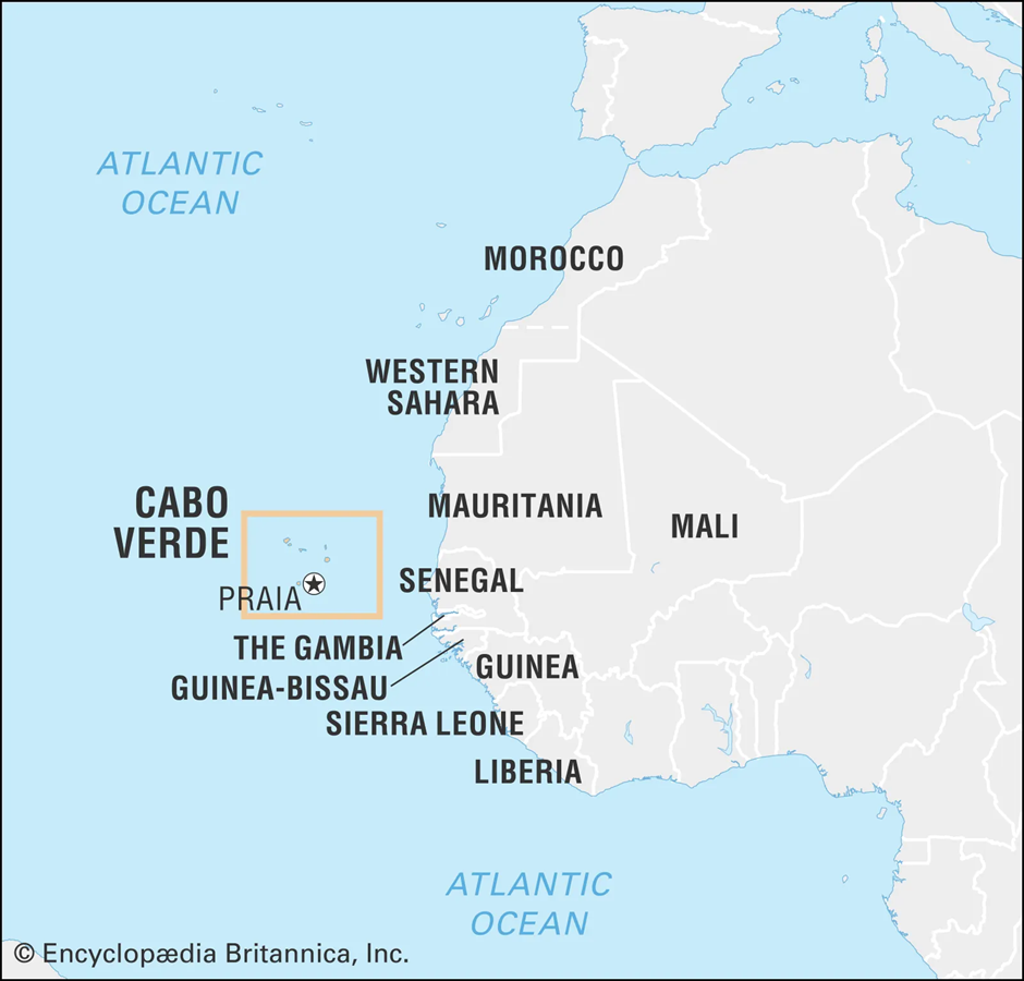
- Location and Geography:
- Cabo Verde, also known as Cape Verde, is an archipelago situated in the central Atlantic Ocean, approximately 570 kilometres off the western coast of Africa, near Senegal.
- The nation comprises ten islands and five islets, covering a total area of about 4,033 square kilometres. These islands are divided into two groups: the Barlavento (windward) islands—Santo Antão, São Vicente, Santa Luzia, São Nicolau, Sal, and Boa Vista; and the Sotavento (leeward) islands—Maio, Santiago, Fogo, and Brava. The largest island, Santiago, hosts the capital city, Praia.
- Geographically, the islands vary from flat, sandy terrains to mountainous regions with volcanic origins, contributing to diverse landscapes and microclimates across the archipelago.
- Impact of Climate Change:
- Cabo Verde faces significant challenges due to climate change, including rising sea levels, increased frequency of extreme weather events, and prolonged droughts. These environmental shifts threaten the nation's water resources, agriculture, and coastal infrastructure.
- The archipelago relies heavily on imported food—about 80%—making it vulnerable to global supply disruptions exacerbated by climate-related events. Additionally, the decline in precipitation has led to reduced agricultural productivity, impacting food security and the livelihoods of rural communities.
- The government has initiated various adaptation strategies, including investments in renewable energy and sustainable development projects, to mitigate these adverse effects.
Tungabhadra River
Why in news?
The Tungabhadra River has turned green around the villages of Shiranahalli, Gangapur, and Korlahalli in Mundargi taluk of Gadag district, Karnataka, raising concerns among local residents.
About Tungabhadra River:
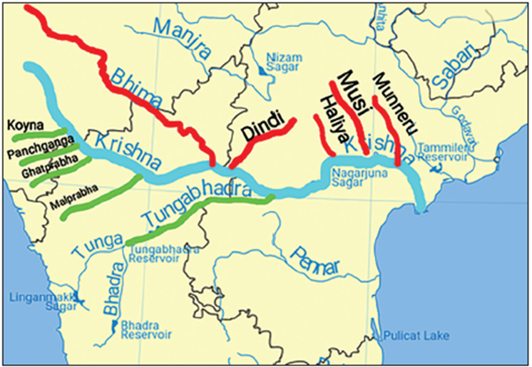
- Origin:
- The Tungabhadra River originates from the confluence of the Tunga and Bhadra rivers at Koodli in the Shimoga district of Karnataka, India.
- The Tunga River itself originates from the Bhadravathi range in the Western Ghats, while the Bhadra River originates from the Bhadra Wildlife Sanctuary in the same region.
- After their confluence, the Tungabhadra flows through the states of Karnataka and Andhra Pradesh, covering a total length of approximately 531 kilometres. It eventually merges with the Krishna River at Sangamaleshwaram in Andhra Pradesh.
- The river is supported by several tributaries, including the Varada River and the Hagari (Vedathy) River. These tributaries contribute to the river's flow and support the agricultural activities in the region.
- The Tungabhadra Dam, located near Hospet in Karnataka, is a significant structure built across the river. Constructed in 1953, the dam serves multiple purposes, including irrigation, power generation, and drinking water supply.
- It plays a crucial role in supporting the agricultural economy of the region, particularly in the Rayalaseema area of Andhra Pradesh.
- Cultural Significance:
- The river holds cultural and religious significance in Hinduism, often referred to as Pampa in ancient texts like the Ramayana.
- The region around the river, especially near Hampi, is renowned for its historical ruins and temples, reflecting the rich cultural heritage of the Vijayanagara Empire.
- Hampi, a UNESCO World Heritage Site, is situated on the southern banks of the Tungabhadra River and is famous for its ancient temples, monuments, and the iconic Virupaksha Temple.
- Ecological challenges:
- In recent years, the river has faced environmental challenges, including pollution and algal blooms.
- For instance, in 2019, the water turned dark green due to algae blooms, attributed to pollution from industrial waste and agricultural runoff.
- Such environmental issues have raised concerns about water quality and the health of aquatic ecosystems.
Pench Tiger Reserve
Why in news?
The Income Tax Department recently uncovered benami transactions involving resorts in the Pench Tiger Reserve, located in Madhya Pradesh, famously known as the ‘Land of Jungle Book’s Mowgli’.
About Pench Tiger Reserve:
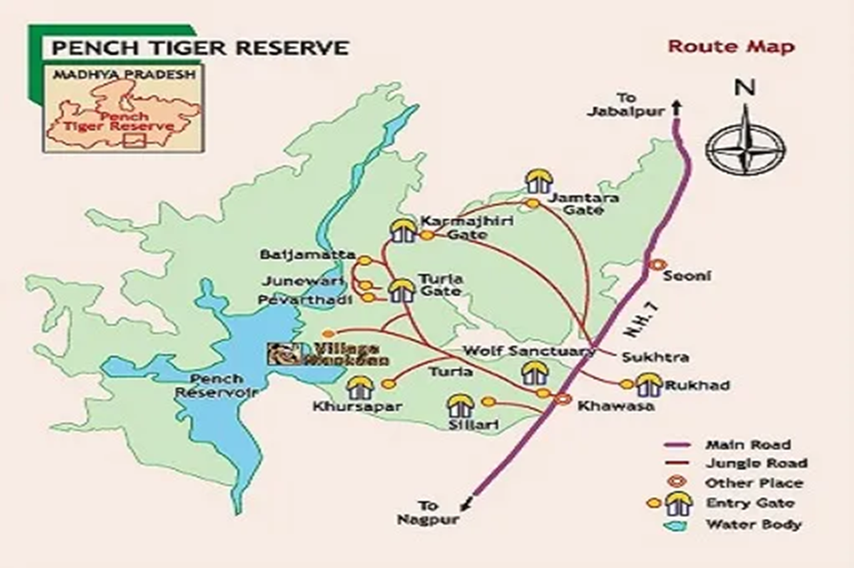
- Location and geography:
- Pench Tiger Reserve is situated in the southern part of Madhya Pradesh, India, spanning the Seoni and Chhindwara districts. It shares a boundary with Maharashtra and is part of the Satpura Range.
- The reserve is divided by the Pench River, which flows from north to south, creating diverse habitats on either side. The landscape features a mix of dry deciduous forests, open grasslands, and riverine ecosystems, contributing to its rich biodiversity.
- Flora and Fauna:
- The flora of Pench Tiger Reserve includes teak, sal, saja, and bamboo, among other species.
- The fauna is equally diverse, with notable species such as the Bengal tiger, Indian leopard, sloth bear, wild dog (dhole), gaur (Indian bison), nilgai, sambar, chital, and chinkara.
- The reserve is also home to over 250 species of birds, including the Indian roller, crested serpent eagle, and white-eyed buzzard, making it a haven for bird watchers.
- Conservation efforts:
- Pench Tiger Reserve has been a focal point for tiger conservation efforts. The reserve is part of the Project Tiger initiative, aiming to protect and increase the tiger population.
- The reserve has witnessed a significant rise in tiger numbers, with regular sightings and photographic evidence of tigers, including the famous tigress Collarwali, also known as Mataram, who has been instrumental in the reserve's breeding success.
- The reserve gained international fame as the inspiration for Rudyard Kipling's "The Jungle Book," with the character Mowgli believed to be based on the region's wildlife and landscapes.
- This connection has enhanced the reserve's appeal, attracting tourists and wildlife enthusiasts from around the world.
|
UPSC CSE PYQs Q1. Consider the following pairs:
Which of the pairs given above are correctly matched? (2019)
Answer: Option A
|
|
Also Read |
|
| Public Administration Optional | |
| Question Answer Practice For UPSC | |

Sailing into Self-Reliance: The Legacy of INS Tamal

Socialism and Secularism: Foundational Pillars of the Indian Constitution

Forest Clearance for Puri Airport Deferred Over Wildlife Concerns
Karol Bagh Metro Pillar No. 112, Above Domino's, 22B, First Floor, New Delhi - 110060
Very Important Instruction For Any Issue, Student Must Produce His/Her Fee Receipt. Without Fee Receipt, It Will Not Be Possible To Track Your Details. If You Have Been Given Any Special Consideration, You Must Keep That In Writing And Produce In Case Of Conflict.
Copyright © 2024-2026 ENSURE IAS. All rights reserved.