- Courses
- GS Full Course 1 Year
- GS Full Course 2 Year
- GS Full Course 3 Year
- GS Full Course Till Selection
- Answer Alpha: Mains 2025 Mentorship
- MEP (Mains Enrichment Programme) Data, Facts
- Essay Target – 150+ Marks
- Online Program
- GS Recorded Course
- Polity
- Geography
- Economy
- Ancient, Medieval and Art & Culture AMAC
- Modern India, Post Independence & World History
- Environment
- Governance
- Science & Technology
- International Relations and Internal Security
- Disaster Management
- Ethics
- NCERT Current Affairs
- Indian Society and Social Issue
- NCERT- Science and Technology
- NCERT - Geography
- NCERT - Ancient History
- NCERT- World History
- NCERT Modern History
- CSAT
- 5 LAYERED ARJUNA Mentorship
- Public Administration Optional
- ABOUT US
- OUR TOPPERS
- TEST SERIES
- FREE STUDY MATERIAL
- VIDEOS
- CONTACT US
PLACES IN NEWS 17th June 2025
PLACES IN NEWS 17th June 2025
17-06-2025

1. IRAN
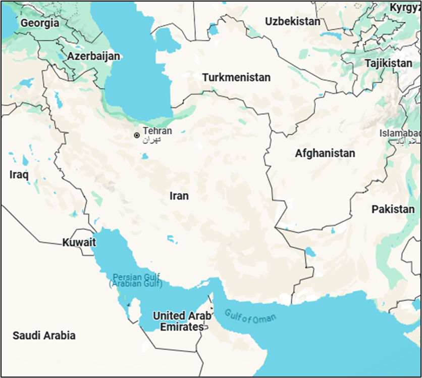
- Iran, officially the Islamic Republic of Iran, is a geopolitically and geostrategically significant country in Western Asia, occupying a pivotal location at the crossroads of Central Asia, South Asia, and the Middle East. Here's a detailed breakdown of its geography:
- Location and Extent:
- Continent: Asia
- Coordinates: Approximately between 25°N to 40°N latitude and 44°E to 63°E longitude
- Borders:
- North: Armenia, Azerbaijan, Turkmenistan, and the Caspian Sea
- East: Afghanistan and Pakistan
- West: Turkey and Iraq
- South: Persian Gulf and Gulf of Oman (with maritime boundaries with UAE, Saudi Arabia, Oman)
- Strategic Significance
- Iran controls the Strait of Hormuz, a crucial choke point through which ~20% of global petroleum passes.
- Acts as a land bridge between the Middle East, Central Asia, and the Indian subcontinent.
- Major Physiographic Regions
- Zagros Mountains: Extend along western Iran, forming a rugged terrain.
- Elburz Mountains: Located in the north, with Mount Damavand (5,610 m), the highest peak in Iran.
- Central Plateau: A large desert basin region including:
- Dasht-e Kavir (Great Salt Desert)
- Dasht-e Lut (one of the hottest places on Earth)
- Khuzestan Plain: Fertile area in the southwest near the Iraq border, rich in oil.
- Coastal Regions:
- Northern: Caspian Sea coast – lush and humid
- Southern: Persian Gulf and Gulf of Oman – arid and hot
- Climate: Mostly arid and semi-arid with significant continental variations.
- Caspian Sea region: Subtropical and humid
- Desert interiors: Extreme heat and dryness
- Mountain regions: Cold and snowy in winters
- Rivers and Water Bodies
- Karun River: Iran's only navigable river; vital for irrigation and transport.
-
-
- Lake Urmia: A large salt lake in the northwest, shrinking due to overuse and climate change.
- Caspian Sea: Largest enclosed inland water body in the world; shared with other Caspian littoral states.
- Persian Gulf & Gulf of Oman: Provide maritime access and strategic depth.
- Natural Resources:
- Rich in oil and natural gas – among the world’s top holders.
-
-
-
- Also has deposits of copper, iron ore, zinc, coal, and uranium.
- Human Geography:
- Major cities: Tehran (capital), Mashhad, Isfahan, Shiraz, Tabriz
-
-
-
- Ethnic diversity: Persians (majority), Azeris, Kurds, Lurs, Balochs, Arabs, and Turkmens
- Population concentrated around foothills, rivers, and coastal plains, avoiding desert interiors.
- Geopolitical Relevance:
- Iran's geography gives it influence over:
- Energy trade routes
- Land access to Central Asia
- Maritime access to Indian Ocean Region (IOR)
- Iran's geography gives it influence over:
-
2. Israel
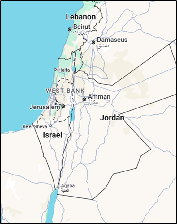
- Location and Extent
- Located in the Middle East, at the eastern end of the Mediterranean Sea.
- Bordered by:
- Lebanon (north)
- Syria (northeast)
- Jordan (east)
- Egypt (southwest)
- Palestinian Territories (West Bank & Gaza Strip)
- Coordinates: 31°N, 35°E
- Total Area: Approx. 22,000 sq km (small country, about the size of Meghalaya)
- Physical Features
- Coastal Plain:
- i. Along the Mediterranean Sea.
- ii. Fertile land, urbanized (Tel Aviv, Haifa).
- iii. Major economic and population zone.
- Central Highlands:
- i. Includes Judean and Samarian Hills.
- ii. Jerusalem is located here (~750m above sea level).
- iii. Rugged terrain, moderate rainfall.
- Jordan Rift Valley:
- i. A part of the Great African Rift System.
- ii. Includes the Jordan River, Sea of Galilee, and Dead Sea.
- iii. Dead Sea: Earth’s lowest point on land (approx. 430 m below sea level).
- Negev Desert:
- i. Covers more than 50% of Israel’s area (south).
- ii. Arid, rocky desert with sparse population.
- iii. Towns: Beersheba, Eilat.
- Coastal Plain:
- Rivers and Water Bodies:
- Jordan River: Main river (flows from Mount Hermon to the Dead Sea).
- Sea of Galilee (Lake Kinneret): Freshwater source.
- Dead Sea: Highly saline, no aquatic life.
- Yarmouk River: Tributary of Jordan River (shared with Syria and Jordan).
- Climate
- Mediterranean Climate in the north and coastal plain (wet winters, dry summers).
- Semi-arid to arid in the south (Negev Desert).
- Rainfall varies from 700 mm/year in the north to <100 mm/year in the south.
- Frequent droughts and water scarcity.
- Natural Resources
- Scarce water, major constraint.
- Minerals: Potash, bromine, phosphates (from Dead Sea).
- Natural gas: Offshore reserves (Tamar, Leviathan fields).
- Agricultural innovation: Drip irrigation, greenhouse farming.
- Geopolitical Significance
- Controls strategic terrain near Suez Canal and Red Sea (via Eilat).
- Proximity to conflict-prone areas: Golan Heights, West Bank, Gaza Strip.
- Shared water sources: hydro-political tensions (Jordan River Basin).
- Environmental Issues
- Water scarcity and over-extraction of aquifers.
- Land degradation in arid regions.
- Urban sprawl and loss of biodiversity.
- Climate change impacts rainfall and agriculture.
- Strategic Geographic Features
- Golan Heights: Occupied from Syria in 1967; important for defense and water sources.
- Red Sea Access: Eilat Port gives access to Asian and African trade.
- Mediterranean Ports: Haifa, Ashdod, vital for trade and energy.

India's 2027 Digital Census Notified
India’s Nuclear Liability Law Debate
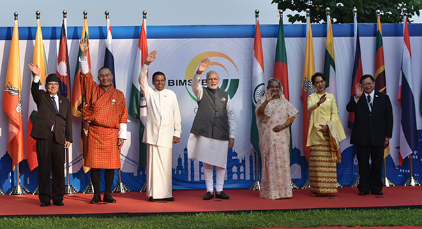
Balancing Power and Trust in the Bay of Bengal
Karol Bagh Metro Pillar No. 112, Above Domino's, 22B, First Floor, New Delhi - 110060
Very Important Instruction For Any Issue, Student Must Produce His/Her Fee Receipt. Without Fee Receipt, It Will Not Be Possible To Track Your Details. If You Have Been Given Any Special Consideration, You Must Keep That In Writing And Produce In Case Of Conflict.
Copyright © 2024-2026 ENSURE IAS. All rights reserved.