- Courses
- GS Full Course 1 Year
- GS Full Course 2 Year
- GS Full Course 3 Year
- GS Full Course Till Selection
- Answer Alpha: Mains 2025 Mentorship
- MEP (Mains Enrichment Programme) Data, Facts
- Essay Target – 150+ Marks
- Online Program
- GS Recorded Course
- Polity
- Geography
- Economy
- Ancient, Medieval and Art & Culture AMAC
- Modern India, Post Independence & World History
- Environment
- Governance
- Science & Technology
- International Relations and Internal Security
- Disaster Management
- Ethics
- NCERT Current Affairs
- Indian Society and Social Issue
- NCERT- Science and Technology
- NCERT - Geography
- NCERT - Ancient History
- NCERT- World History
- NCERT Modern History
- CSAT
- 5 LAYERED ARJUNA Mentorship
- Public Administration Optional
- ABOUT US
- OUR TOPPERS
- TEST SERIES
- FREE STUDY MATERIAL
- VIDEOS
- CONTACT US
PLACES IN NEWS 15th FEBRUARY 2025
PLACES IN NEWS 15th FEBRUARY 2025

Jhelum River
Why in news?
- Pollution, encroachments, and climate change are degrading Jhelum River and Dal Lake, threatening Kashmir’s ecosystem.
- Reduced water flow, siltation, and waste accumulation are causing ecological suffocation, endangering livelihoods and biodiversity.
About Jhelum River:
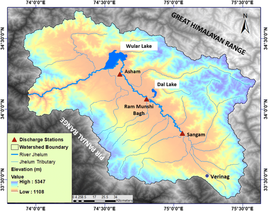
- Location and Origin:
- The Jhelum River originates from a natural spring at Verinag in the southeastern part of the Kashmir Valley. It is the region's largest and most significant river, playing a crucial role in its hydrology.
- The river follows a northward course, entering Wular Lake before changing direction southward. It then flows through the Baramulla region, carving a narrow gorge in the Pir Panjal Range.
- With a total length of approximately 724 km, the Jhelum flows through India and Pakistan. It serves as a boundary between the two nations for about 170 km before entering the Potwar Plateau.
- The river eventually merges with the Chenab at Trimmu, contributing to the extensive Indus River system. While historically a vital waterway, only about 160 km remains navigable today.
- Environmental Concerns and Challenges:
- Rapid urbanisation, deforestation, and unregulated waste disposal have severely polluted and degraded the Jhelum River. Siltation and encroachments further threaten its natural flow.
- Reduced water levels, climate change, and erratic rainfall patterns have increased concerns over its sustainability, affecting agriculture and hydropower projects dependent on its waters.
- Conservation efforts are necessary to restore the river’s ecological balance, ensuring its survival for future generations. Sustainable management practices and pollution control measures are crucial to safeguarding its health.
About Dal Lake:
- Location:
- Dal Lake, located in Srinagar, the capital of Jammu and Kashmir, is one of the most famous tourist attractions in the region. Interestingly, the name "Dal Lake" is a misnomer, as Dal itself means lake in Kashmiri.
- Often referred to as the “Jewel in the Crown of Kashmir” or “Srinagar’s Jewel,” it plays a crucial role in tourism and recreation, attracting visitors with its breath-taking landscape and serene waters.
- Geographical Features and Floating Gardens:
- Spanning approximately 18 square kilometres, Dal Lake forms a part of a larger natural wetland ecosystem, which includes its famous floating gardens.
- These floating gardens, locally known as “Raad,” bloom with lotus flowers during July and August, adding to the lake’s scenic beauty.
- The lake is divided into four basins—Gagribal, Lokut Dal, Bod Dal, and Nagin—each separated by causeways. In the centre of Lokut Dal and Bod Dal, two islands stand out—Rup Lank (Char Chinari) and Sona Lank, both known for their picturesque charm.
- Houseboats and Cultural Importance:
- Houseboats and shikaras are an integral part of the Dal Lake experience, offering unique floating accommodations that provide visitors with an immersive stay in the heart of Srinagar.
- The traditional shikaras, or wooden boats, serve as a primary mode of transport on the lake, used for tourism, fishing, and local trade.
- The lake continues to be an emblem of Kashmir’s rich cultural heritage, drawing artists, poets, and travellers who find inspiration in its tranquil waters and stunning surroundings.
- Beyond its aesthetic appeal, the lake also supports commercial activities such as fishing and water plant harvesting, making it an important resource for local livelihoods.
Bhadra Tiger Reserve
Why in news?
Wildlife activists seek an investigation into a leopard’s death in Bhadra Tiger Reserve, suspecting foul play. Concerns over poaching, habitat threats, and inadequate protection measures have intensified calls for accountability and conservation efforts.
About Bhadra Tiger Reserve:
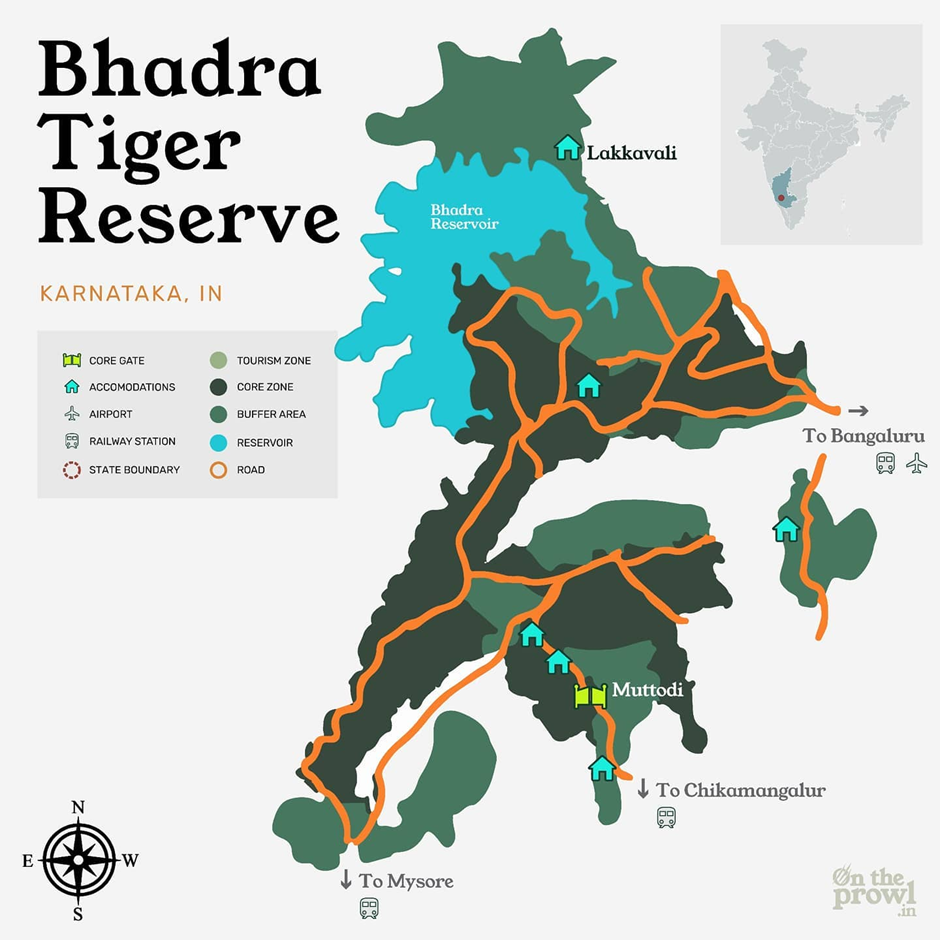
1. Location and Geography:
- Bhadra Tiger Reserve, part of Project Tiger, is situated in the Chikkamagaluru district of Karnataka, approximately 23 km south of Bhadravathi and 283 km from Bengaluru.
- The reserve spans two sections: the Lakkavalli-Muthodi section in the west and the Bababudangiri section in the east, covering diverse elevations ranging from 615 m to 1,875 m above sea level.
- It is surrounded by the Mullayanagiri, Hebbegiri, Gangegiri, and Bababudangiri hills, with Hebbe Giri (1,875 m) as the highest peak within the reserve.
- The Bhadra River and its tributaries flow through the sanctuary, supporting its rich ecosystem.
2. Flora and Fauna:
- The reserve features moist deciduous, dry deciduous, and semi-evergreen forests, with a variety of trees like teak, rosewood, sandalwood, and fig.
- It is home to tigers, leopards, elephants, Indian gaurs, sloth bears, and dholes, making it a significant biodiversity hotspot. The avian diversity includes species like the Malabar pied hornbill, paradise flycatcher, and crested serpent eagle.
Ethiopia
Why in news?
Ethiopia’s new map claims parts of Somalia, Eritrea, and Djibouti, sparking regional tensions. The issue was raised at the 38th African Union Summit, which is going to be held on February 15-16, 2025, in Ethiopia, where neighbouring countries rejected Ethiopia’s territorial assertions, citing historical disputes.
About Ethiopia:
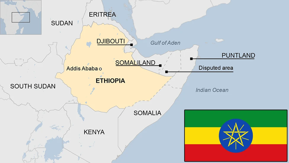
- Location and Geographical Significance:
- Ethiopia, located in the Horn of Africa, is a landlocked country bordered by Eritrea to the north, Djibouti and Somalia to the east, Kenya to the south, South Sudan to the west, and Sudan to the northwest.
- It is Africa’s second-most populous country and is strategically important due to its proximity to the Red Sea, Bab-el-Mandeb Strait, and the Gulf of Aden, key maritime trade routes.
- Despite being landlocked since Eritrea’s independence in 1993, Ethiopia remains a dominant power in East Africa.
- Controversial Territorial Claims in Ethiopia’s New Map: Ethiopia recently published a new map that controversially includes parts of Somalia, Eritrea, and Djibouti, escalating regional tensions. The specific areas in dispute include:
- Somalia—Ethiopia's new map reportedly includes Somaliland, a self-declared autonomous region of Somalia, which Ethiopia has sought to engage with for port access. Additionally, Ethiopia's claims extend towards Hobyo Port, a strategically located port in central Somalia. Control over Hobyo would strengthen Ethiopia’s maritime access, further straining its relations with Mogadishu (the capital of Somalia).
- Eritrea—Parts of Eritrea’s border regions appear incorporated, reviving old hostilities stemming from the 1998-2000 Ethiopia-Eritrea war over the Badme region. Ethiopia’s claims threaten to disrupt the fragile peace between the two nations.
- Djibouti—Ethiopia's map allegedly extends into Djibouti, a critical transit hub for Ethiopian trade and home to foreign military bases, including those of the U.S., China, and France. Djibouti plays a key role in regional logistics, and any Ethiopian claim over its territory could destabilise existing economic and security arrangements.
- Internal Conflicts in Ethiopia: Ethiopia has faced prolonged internal conflicts fuelled by ethnic tensions, political struggles, and historical grievances. The most prominent areas of conflict include:
- Tigray Conflict:
- Originating in November 2020, the conflict between the Tigray People's Liberation Front (TPLF) and the Ethiopian federal government escalated into a full-scale civil war.
- The Ethiopian government, alongside Eritrean forces and the Amhara regional militia, fought against TPLF forces, leading to widespread atrocities, mass displacement, and famine-like conditions.
- A peace deal was signed in November 2022, but tensions remain, with reports of continued human rights violations.
- Amhara Conflict:
- The Amhara region, historically allied with the government against Tigray, turned volatile when the Amhara Fano militia clashed with federal forces.
- Discontent grew after the government moved to integrate regional forces into the national army, triggering resistance from Amhara nationalists who feared marginalisation.
- The region has seen an increase in military crackdowns, civilian casualties, and protests, highlighting Ethiopia’s fragile security situation.
- Oromo Insurgency:
- The Oromo Liberation Army (OLA) continues an armed rebellion against the Ethiopian government, demanding greater autonomy for the Oromo ethnic group, Ethiopia’s largest.
- The conflict has led to violence in the Oromia region, with thousands displaced and numerous reports of human rights abuses.
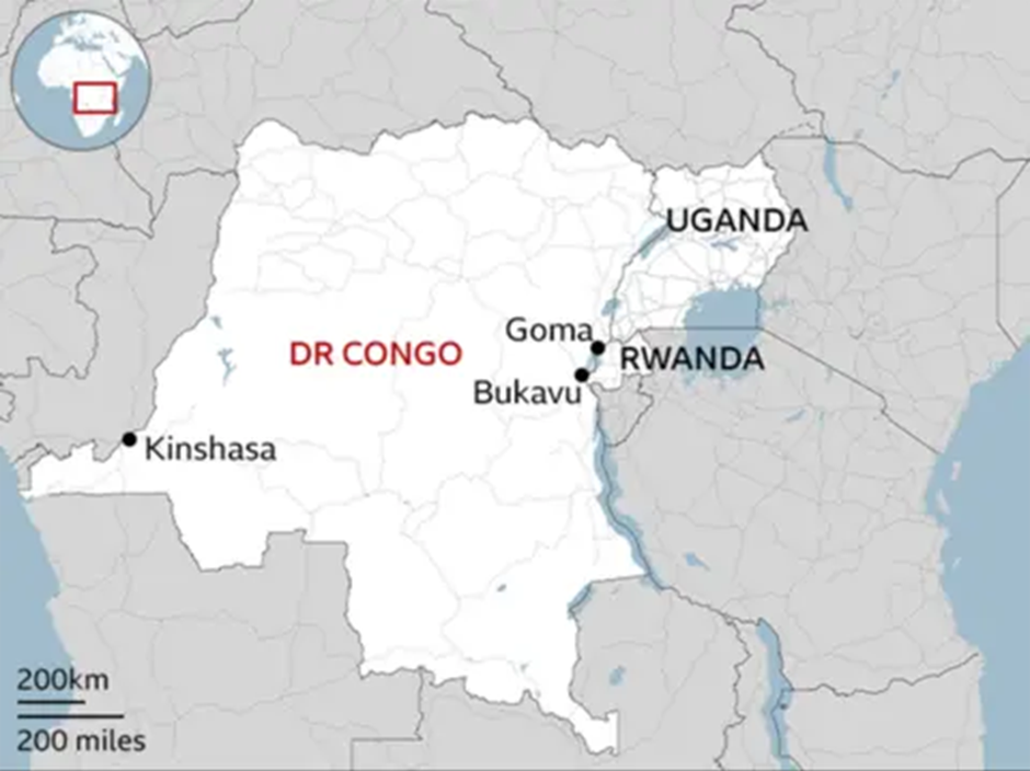
Bukavu
Why in news?
Fears have gripped Bukavu, a major city in eastern DR Congo, as M23 rebels seized a key airport nearby. The development threatens regional security, raising concerns over potential spillover violence, displacement, and instability.
About Bukavu:
-
- Location and Importance:
- Location and Importance:
- Bukavu is a major city in the eastern Democratic Republic of the Congo (DRC), situated on the southwestern shore of Lake Kivu near the border with Rwanda.
- It serves as the capital of South Kivu province and is a key economic and administrative centre.
- Due to its proximity to Rwanda and Burundi, Bukavu has historically been a hotspot for cross-border tensions and rebel activity.
- M23 Expansion and Associated Regions:
- M23 Expansion and Associated Regions:
- The March 23 Movement (M23), a rebel group active in North Kivu, has been expanding its control in eastern DRC, recently seizing key locations, including an airport near Bukavu.
- This expansion has raised fears that the conflict may spread into South Kivu, further destabilising Bukavu and surrounding areas.
- Other conflict-affected regions include Goma, the capital of North Kivu, which has frequently been targeted by M23 attacks, heightening tensions in the region.
- The rebels have also gained territorial control in Rutshuru and Masisi, further consolidating their presence in eastern DRC.
- Additionally, Ituri province remains plagued by violence from multiple armed groups, exacerbating instability and humanitarian crises.
- The continued expansion of M23 and other militias across these regions threatens to further destabilise Bukavu and South Kivu, increasing fears of widespread conflict and displacement.
|
UPSC CSE PYQs Q1. Consider the following statements:
How many of the statements given above are correct? (2023)
Answer: Option A Q. Consider the following pairs:
How many of the above pairs are correctly matched? (2023)
Answer: Option D
Q. Consider the following pairs:
|
|
Also Read |
|
| Public Administration Optional | |
| UPSC Monthly Magazine | Question Answer Practice For UPSC |

ECI to Verify Voter List in Bihar

India Opens Doors to Foreign Universities

Coordination Between Fiscal and Monetary Policy
Karol Bagh Metro Pillar No. 112, Above Domino's, 22B, First Floor, New Delhi - 110060
Very Important Instruction For Any Issue, Student Must Produce His/Her Fee Receipt. Without Fee Receipt, It Will Not Be Possible To Track Your Details. If You Have Been Given Any Special Consideration, You Must Keep That In Writing And Produce In Case Of Conflict.
Copyright © 2024-2026 ENSURE IAS. All rights reserved.