- Courses
- GS Full Course 1 Year
- GS Full Course 2 Year
- GS Full Course 3 Year
- GS Full Course Till Selection
- CSAT
- 5 LAYERED ARJUNA Mentorship
- Public Administration Optional
- Online Program
- GS Recorded Course
- NCERT (Recorded 500+ Hours)
- Polity Recorded Course
- Geography Recorded Course
- Economy Recorded Course
- AMAC Recorded Course
- Modern India, Post Independence & World History
- Environment Recoded Course
- Governance Recoded Course
- Science & Tech. Recoded Course
- International Relations and Internal Security Recorded Course
- Disaster Management Module Course
- Ethics Recoded Course
- Essay Recoded Course
- Current Affairs Recoded Course
- ABOUT US
- OUR TOPPERS
- TEST SERIES
- FREE STUDY MATERIAL
- VIDEOS
- CONTACT US
PLACES IN NEWS 11th APRIL 2025
PLACES IN NEWS 11th APRIL 2025
11-04-2025

Thar Desert
Why in news?
- A study shows Thar Desert greening rose 38% annually in two decades due to increased monsoon rainfall and agricultural growth.
About Thar Desert:
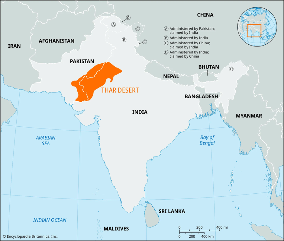
- Geography:
- The Thar Desert, also known as the Great Indian Desert, is a vast arid region located in the north-western part of the Indian subcontinent.
- It spans approximately 200,000 square kilometres, making it the 9th largest subtropical desert in the world.
- The desert lies primarily in the Indian state of Rajasthan, but it also extends into southern Haryana and Punjab and northern Gujarat. About 15% of the desert stretches into the Punjab and Sindh regions of Pakistan.
- The Thar is bounded by the Sutlej River to the northwest, the Aravalli Hills to the east, the Rann of Kutch to the south, and the Indus Valley to the west.
- Its terrain is diverse, with around 10% consisting of sand dunes, while the rest includes craggy rocks, compacted salt lake beds, and gravel plains.
- Unlike many major deserts, the Thar lacks natural oases, making it unique in its arid characteristics.
- The desert's name is derived from the word thul, meaning sand ridges, reflecting its undulating landscape.
- The only river that flows through the region is the Luni River, which is seasonal and saline in nature.
- Climate and Biodiversity:
- The Thar Desert experiences an extreme climate, with scorching summer temperatures reaching up to 50°C and winter temperatures dropping close to freezing.
- Annual rainfall is sparse, ranging between 10 and 50 cm, concentrated mainly during the short monsoon season.
- Intense dust storms are common during the summer months, further shaping the desert landscape.
- Vegetation is sparse and dominated by xerophilous (drought-resistant) plant species such as khejri, cactus, and thorny bushes.
- Despite the harsh environment, the Thar is the most densely populated desert in the world, with about 83 people per square kilometre.
- Wildlife includes desert foxes, chinkaras, monitor lizards, and several bird species like the Great Indian Bustard, which is critically endangered.
- It also supports a wide range of insects and reptiles adapted to arid conditions.
- Resources and Significance:
- The Thar Desert is rich in mineral resources such as gypsum, limestone, salt, bauxite, and silica.
- Notably, it holds one of India’s largest coal reserves, contributing significantly to the region's economy.
- Agricultural expansion and increased monsoon activity in recent years have led to notable greening in some parts, indicating shifting ecological dynamics in the region.
Mandovi River
Why in news?
- Karnataka farmers back Goa activists opposing Mandovi River (Mhadei) water diversion threatening ecology.
About Mandovi River:
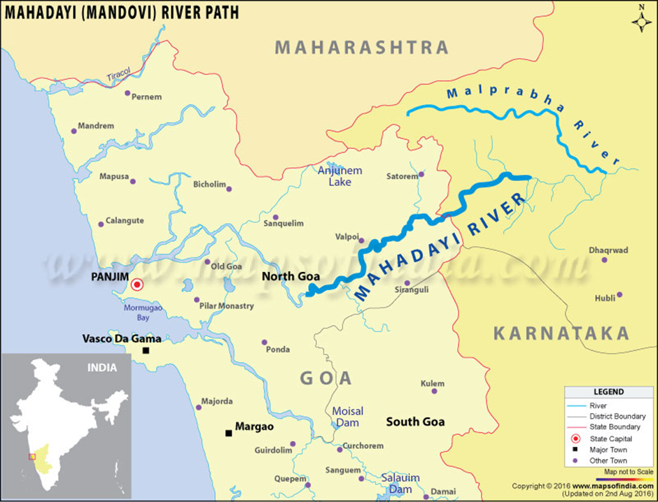
- Geography:
- The Mandovi River, also known as the Mhadei in Karnataka, originates from a cluster of 30 springs in the Western Ghats at Bhimgad in the Belagavi district of Karnataka.
- It flows through Maharashtra (1 km), Karnataka (35 km), and Goa (45 km) before draining into the Arabian Sea at the Mormugao Harbour.
- The river traverses through ecologically rich regions like Dudhsagar Falls, Varapoha Falls, and Bhimgad Wildlife Sanctuary, making it a vital freshwater source and tourist attraction.
- The Mandovi and its tributaries, such as the Mapusa River, Valvanti River, and Dudhsagar River, sustain three major islands in Goa—Divar, Chorão, and Vanxim, home to ecosystems like the Salim Ali Bird Sanctuary.
- Ecological Significance:
- Often described as the lifeline of Goa, the Mandovi is crucial for the state’s drinking water, irrigation, and biodiversity.
- The river sustains dense Western Ghats forests, helps recharge groundwater, and regulates the microclimate of the region.
- Its estuary supports inland navigation and the export of iron ore, vital to Goa’s economy.
- It also plays a role in ecotourism, particularly through its scenic cruises and wetland ecosystems.
- Water Diversion Controversy:
- The Kalasa-Banduri Project by Karnataka aims to divert Mhadei waters to the Malaprabha River to meet drinking water needs in Hubballi-Dharwad.
- However, locals in Khanapur (Karnataka) and activists from Goa argue the diversion will lead to deforestation, habitat loss, and water scarcity.
- The project has triggered interstate disputes, with both Karnataka and Goa challenging the Mahadayi Water Tribunal’s 2018 verdict in the Supreme Court.
- Goa opposes the diversion, citing ecological damage, and claims illegal canal work is already underway despite a court stay.
Aravalli range
Why in news?
- NGT stresses strict curbs to prevent illegal mining in Aravalis, especially on land protected under the Great Nicobar project swap.
About Aravalli range:
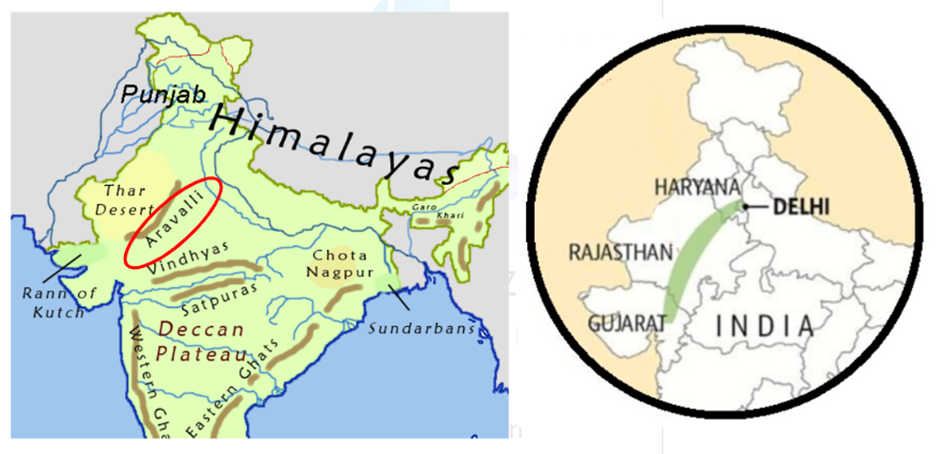
- Location:
- The Aravalli Range, one of the oldest mountain systems in the world, stretches across northwestern India, running approximately 800 km through the states of Gujarat, Rajasthan, Haryana, and Delhi.
- Formed in the Precambrian era (4.6 billion years to 540 million years ago), these hills are rich in minerals and biodiversity and act as a vital ecological barrier preventing desertification from the Thar Desert.
- Geography and Topography
- The Aravallis originate in Gujarat’s Palanpur district and extend northwards to Delhi, passing through Rajasthan and southern Haryana. The terrain is undulating with isolated hills, ridges, and valleys.
- Several important rivers emerge from the Aravalli hills, including the Banas, Sabarmati, Luni, and Sahibi, serving as lifelines for the semi-arid regions of Rajasthan and adjoining states.
- Ecological Significance and Biodiversity
- The Aravallis are home to diverse flora and fauna, including endangered species such as the rusty-spotted cat, striped hyena, golden jackal, chinkara, jungle cat, and Indian small civet.
- Rich avian life like owls and eagles are also found here. Medicinal plants such as Salar, Hadjod, and Sada Hari Bel are used by locals for traditional healing, and native tree species like Khair, Dhok, Rohida, and Khejri contribute to the forest’s ecological balance.
- The region also provides grazing land and fuelwood for local communities and holds religious significance due to sacred groves.
- Illegal Mining and Conservation Challenges
- Illegal mining has severely degraded the Aravallis, especially in Haryana's Mahendergarh and Faridabad districts.
- In Rajawas village, 506.33 acres were designated as ‘Protected Forest’ under the Forest (Conservation) Act, 1980, through a June 2023 notification as part of a compensatory afforestation scheme—the Great Nicobar Project Swap.
- However, on the same day, the Haryana mining department auctioned nearly 25% of this protected land for mining, leading to widespread local opposition.
- Following a Times of India report on this issue, the National Green Tribunal (NGT) took suo motu cognisance in October 2024.
- Great Nicobar Project Swap
- The forest area in Rajawas is part of a compensatory afforestation plan under which forests diverted for the Great Nicobar Infrastructure Project—a strategic initiative in the Andaman and Nicobar Islands—must be compensated by identifying and protecting equivalent forest land elsewhere.
- However, environmentalists argue that substituting dense evergreen rainforests of Nicobar with semi-arid forests of Aravallis not only dilutes biodiversity value but also fails to compensate ecologically.
Guindy National Park
Why in news?
- Efforts underway to restore Guindy National Park’s neglected grasslands, aiming to boost blackbuck population and revive native ecosystem.
About Guindy National Park:
- Location:
- Guindy National Park is located in the heart of Chennai, Tamil Nadu, and is one of the smallest national parks in India, covering just 2.70 km².
- Despite its size, the park is a crucial ecological zone within the urban landscape. It is characterised by a mix of dry evergreen scrub forests, thorn forests, and grasslands, which provide vital habitats for diverse species.
- The park is an extension of the grounds surrounding Raj Bhavan, the official residence of the Governor of Tamil Nadu, and is adjacent to IIT Madras.
- It is one of the few national parks located within a metropolitan area, providing essential green space for both wildlife and city residents.
- Flora and Fauna:
- The park’s flora includes over 350 plant species, such as neem, wood apple, sugar apple, and Acacia planifrons.
- These plants form the foundation of the park's ecosystem, supporting a variety of animals. The fauna is equally diverse, with 14 mammal species, including the blackbuck, which is the flagship species of the park.
- Other animals include the spotted deer, jackals, civets, bonnet macaques, and various species of reptiles like the fan-throated lizard.
- Over 150 bird species, including paradise flycatchers, yellow-wattled lapwings, and black-winged kites, also inhabit the park.
- Additionally, the park supports a variety of insects, amphibians, and reptiles, enhancing its ecological richness.
- Ecological challenges:
- One of the main ecological challenges faced by Guindy National Park is the degradation of its grassland habitats, particularly the Polo Ground.
- Historically used for polo matches during British rule, this area has become overrun by invasive plant species such as Mexican grass.
- The lack of suitable grazing land has directly contributed to the decline in the blackbuck population, as these animals rely heavily on open grasslands for grazing and lek mating displays.
- Conservation efforts are underway to restore this habitat by removing invasive species and planting native grass varieties.
- The restoration of the Polo Ground is critical to the survival of the blackbuck, which depends on the availability of large, open spaces for grazing and breeding.
|
Also Read |
|
| Public Administration Optional | |
| UPSC Monthly Magazine | Question Answer Practice For UPSC |


Golconda Blue

Drugs & Cosmetics (Compounding of Offences) Rules 2025

Project Kuiper
Karol Bagh Metro Pillar No. 112, Above Domino's, 22B, First Floor, New Delhi - 110060
Copyright © 2024-2026 ENSURE IAS. All rights reserved.