- Courses
- GS Full Course 1 Year
- GS Full Course 2 Year
- GS Full Course 3 Year
- GS Full Course Till Selection
- MEP (Mains Enrichment Programme) Data, Facts
- Essay Target – 150+ Marks
- Online Program
- GS Recorded Course
- NCERT- First Ladder
- Polity
- Geography
- Economy
- Ancient, Medieval and Art & Culture AMAC
- Modern India, Post Independence & World History
- Environment
- Governance
- Science & Technology
- International Relations and Internal Security
- Disaster Management
- Ethics
- Current Affairs
- Indian Society and Social Issue
- CSAT
- 5 LAYERED ARJUNA Mentorship
- Public Administration Optional
- ABOUT US
- OUR TOPPERS
- TEST SERIES
- FREE STUDY MATERIAL
- VIDEOS
- CONTACT US
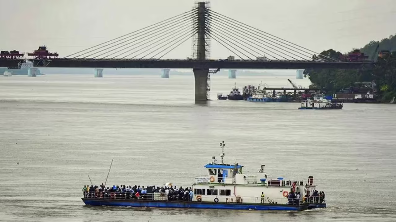
Myth of China’s Control Over the Brahmaputra
Myth of China’s Control Over the Brahmaputra
Context:
- After India suspended the Indus Waters Treaty with Pakistan, discussions about water sharing in South Asia have become more intense.
- This has brought attention to the Brahmaputra River, with India firmly stating that it controls its water resources and rejecting claims that China has significant control over the river’s flow.
- There is a common myth, often spread by Pakistan, that China’s actions on the Brahmaputra could threaten India’s water security.
- However, this claim is based on incorrect information about the river’s geography and water sources.
- Pakistan has historically benefited more than it should have from the Indus Waters Treaty, which limited India’s ability to build water infrastructure in states like Kashmir.
- Now that India is reasserting control over its water resources, Pakistan is trying to create a false story that India depends on China for the Brahmaputra’s water.
About The Brahmaputra River:
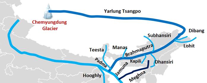
Brahmaputra River:
-
About:
- The Brahmaputra River is known as the Yarlung Tsangpo in Tibet
- Siang or Dihang in Arunachal Pradesh, India.
- Brahmaputra in Assam, India.
- Jamuna in Bangladesh.
- Length: 6th-longest river in Asia, approximately 2,900 km.
- Origin: Originates in the Tibetan Plateau (Chemayungdung mountain ranges at 5,150 meters, near Konggyu Tsho lake).
- The Brahmaputra is primarily a rain-fed river system.
- Only approximately 30-35% of its flow comes from China, mostly from Chemayungdung Glacier melt and scanty rainfall in the Tibetan region.
- This constitutes the base flow.
- The majority of the river’s water (about 65-70%) originates within India itself, mainly from monsoon rains over the Northeast's hilly areas and numerous tributaries.
- Flow: Flows eastward through the Tibetan Plateau, enters India, then Bangladesh, and finally empties into the Bay of Bengal.
- The Brahmaputra River is known as the Yarlung Tsangpo in Tibet
-
The Brahmaputra River Basin
- Total Area: Spreads across Tibet, Bhutan, India, and Bangladesh, covering a total area of 5,80,000 square kilometers.
- It is one of the largest river basins in Asia.
- In India: The Brahmaputra basin covers 1,94,413 square kilometers, which is about 5.9% of India’s total geographical area.
- States Covered: Arunachal Pradesh (81,424 sq km), Assam (70,634 sq km), West Bengal (12,585 sq km), Meghalaya (11,667 sq km), Nagaland (10,803 sq km), and Sikkim (7,300 sq km).
-
Course of the River
- Tibet (Yarlung Tsangpo):
- Flows eastward for about 1600 km through the Tibetan Plateau, parallel to the Himalayas.
- India (Siang/Dihang to Brahmaputra):
- Enters India in Arunachal Pradesh as the Siang or Dihang river.
- Takes an S-shaped bend near Bishing village at the Indian border.
- Further downstream, it is joined by the Lohit and Dibang rivers to form the mighty Brahmaputra river.
- Flows in a south-easterly direction for about 230 km through Arunachal Pradesh before entering the Assam valley.
- Travels a total distance of 916 km within India (through Arunachal Pradesh and Assam).
- Bangladesh (Jamuna to Meghna):
- After entering Bangladesh, it is known as the Jamuna river.
- The Jamuna is joined by the Ganga River (known as the Padma river in Bangladesh).
- Eventually, the Brahmaputra (as Jamuna-Padma) joins the Meghna River and finally empties its water into the Bay of Bengal.
- Tibet (Yarlung Tsangpo):
-
Key Tributaries of the Brahmaputra River
- Left Bank Tributaries (Common Features: flatter grades, fine alluvial soils, low silt, deep meandering channels)
- Siang River:
- Origin: Kailash Range glaciers (Himalayas) at 5300m altitude.
- Course: Known as Yarlung Tsangpo in Tibet; enters India through Arunachal Pradesh (deep gorge); joined by Lohit and Dibang to form Brahmaputra.
- Dibang River:
- Origin: Near Indo-Chinese border in Upper Dibang Valley, Arunachal Pradesh.
- Course: Flows through Mishmi Hills; locally called Sikang; joins Lohit River before merging with Brahmaputra near Sadiya, Assam.
- Tributaries: Dri, Mathun, Talon, Eme, Ahi, Emra, Awa.
- Lohit River:
- Origin: Eastern Tibet (as Zayu River); formed by Kangri Karpo Chu and Zayul Chu.
- Course: Enters India through Arunachal Pradesh (Mishmi Hills); merges with Siang River to form Brahmaputra.
- Features: Reddish color due to lateritic soil; Dhola-Sadiya Bridge (longest in India) over it. Farthest east tributary.
- Burhi Dihing / Dihing River:
- Origin: Eastern Himalayas in Patkai Hills, Arunachal Pradesh; formed by Namphuk and Namchik.
- Course: Flows southwest through Patkai Hills, creating oxbow lakes; joins Brahmaputra at Dihingmukh, Assam (380 km long).
- Significance: Known for tea, rubber, oil fields, diverse flora/fauna (Joy-Dihing tropical rainforest).
- Dhansiri River:
- Origin: Laisang peak in Nagaland.
- Course: Forms boundary between Cachar, Nagaon, Nagaland districts; flows through Karbi-Along and Golaghat districts of Assam; joins Brahmaputra on its south bank (354 km long).
- Significance: Known for rich biodiversity (Joy-Dihing tropical rainforest); isolated Mikir Hills from Peninsular Plateau with Kapili River.
- Kopili River:
- Origin: Saipong Reserve Forest in southeast Meghalaya.
- Course: Forms border between Meghalaya and Assam; flows through Assam before joining Brahmaputra at Kopilimukh (256 km long).
- Features: Rocky, swift, many waterfalls; harnessed for irrigation and power projects (Kopili Hydro Electric Project). Largest south bank tributary in Assam.
- Siang River:
- Right Bank Tributaries (Common Features: steep slope, coarse sandy beds, shallow braided channels, heavy silt charge)
- Subansiri River:
- Origin: Tibet, beyond Himalayas (trans-Himalayan); formed by Tsari Chu, Chayal Chu, Sikung Chu.
- Course: Largest tributary of Brahmaputra; enters India near Taksing (Arunachal Pradesh); joins Brahmaputra at Jamurighat, Assam (442 km long).
- Features: Swift flow, scenic forests, popular for white water rafting. Home to Lower Subansiri Hydro-Electric Project (under construction).
- Kameng River (formerly Bharali River):
- Origin: Glacial lake near Nyegi Kangsang mountain, Arunachal Pradesh.
- Course: Flows through Tawang district; joins Brahmaputra at Tezpur, Assam. Forms boundary between East and West Kameng districts.
- Tributaries: Tippi, Tenga, Bichom, Dirang Chu.
- Manas River:
- Origin: Tibet (trans-Himalayan).
- Course: Flows through Bhutan (largest river system there); enters India and joins Brahmaputra near Jogighopa, Assam.
- Significance: Flows through Royal Manas National Park (Bhutan) and Manas Wildlife Sanctuary (India), home to diverse and endangered wildlife.
- Sankosh River:
- Origin: Northern Bhutan (as Puna Tsang Chu).
- Course: Flows through hilly terrain, enters India forming a border between Assam and West Bengal; enters Bangladesh and joins Brahmaputra near Indo-Bangladesh boundary. Glacial-fed.
- Teesta River:
- Origin: Zemu glacier in Himalayas, North Sikkim (part of Kanchenjunga range).
- Course: Lifeline of Sikkim; flows through narrow gorges; enters plains at Sevoke (Jalpaiguri district); joins Brahmaputra River near Rangpur, Bangladesh (309 km long).
- Features: Carved deep gorge in Darjeeling hills; fed by streams and lakes in Eastern Himalayas.
- Subansiri River:
- Left Bank Tributaries (Common Features: flatter grades, fine alluvial soils, low silt, deep meandering channels)
-
Management Efforts:
- Brahmaputra Board (established 1980): To prepare master plans for flood control and bank erosion prevention.
- Flood Forecasting Systems: Central Water Commission operates 27 flood forecasting stations.
-
India's Water Independence (Flow Rates):
- At the Indo-China border (near Tuting, Arunachal Pradesh), the flow rate is around 2,000-3,000 cubic meters per second.
- During the monsoon season, as the river enters Assam’s plains, the flow dramatically increases to 15,000-20,000 cubic meters per second.
- These figures clearly show that the river's volume is overwhelmingly sustained within India's climatic and geographical boundaries.
|
Ensure IAS Mains Question (250 words) Q: The Brahmaputra River plays an important role in the geography, ecology, and economy of northeastern India. Discuss the myth of China’s control over the Brahmaputra River and analyse India’s water independence in this context. (250 Words) |
|
Ensure IAS Prelim MCQ: Q. Which of the following are right-bank tributaries of the Brahmaputra? 1. Subansiri 2. Manas 3. Dibang 4. Sankosh 5. Kameng Select the correct answer: A. 1, 2 and 4 only B. 3, 4 and 5 only C. 1, 3 and 5 only D. 2, 3 and 4 only Answer: A |
Myth of China’s Control Over the Brahmaputra

UK-EU Reset: A Strategic Opening for India
India-Central Asia Connectivity and Trade
Karol Bagh Metro Pillar No. 112, Above Domino's, 22B, First Floor, New Delhi - 110060
Very Important Instruction For Any Issue, Student Must Produce His/Her Fee Receipt. Without Fee Receipt, It Will Not Be Possible To Track Your Details. If You Have Been Given Any Special Consideration, You Must Keep That In Writing And Produce In Case Of Conflict.
Copyright © 2024-2026 ENSURE IAS. All rights reserved.