- Courses
- GS Full Course 1 Year
- GS Full Course 2 Year
- GS Full Course 3 Year
- GS Full Course Till Selection
- Answer Alpha: Mains 2025 Mentorship
- MEP (Mains Enrichment Programme) Data, Facts
- Essay Target – 150+ Marks
- Online Program
- GS Recorded Course
- Polity
- Geography
- Economy
- Ancient, Medieval and Art & Culture AMAC
- Modern India, Post Independence & World History
- Environment
- Governance
- Science & Technology
- International Relations and Internal Security
- Disaster Management
- Ethics
- NCERT Current Affairs
- Indian Society and Social Issue
- NCERT- Science and Technology
- NCERT - Geography
- NCERT - Ancient History
- NCERT- World History
- NCERT Modern History
- CSAT
- 5 LAYERED ARJUNA Mentorship
- Public Administration Optional
- ABOUT US
- OUR TOPPERS
- TEST SERIES
- FREE STUDY MATERIAL
- VIDEOS
- CONTACT US
Impact and Significance of Earthquake in Tibetan China
Impact and Significance of Earthquake in Tibetan China
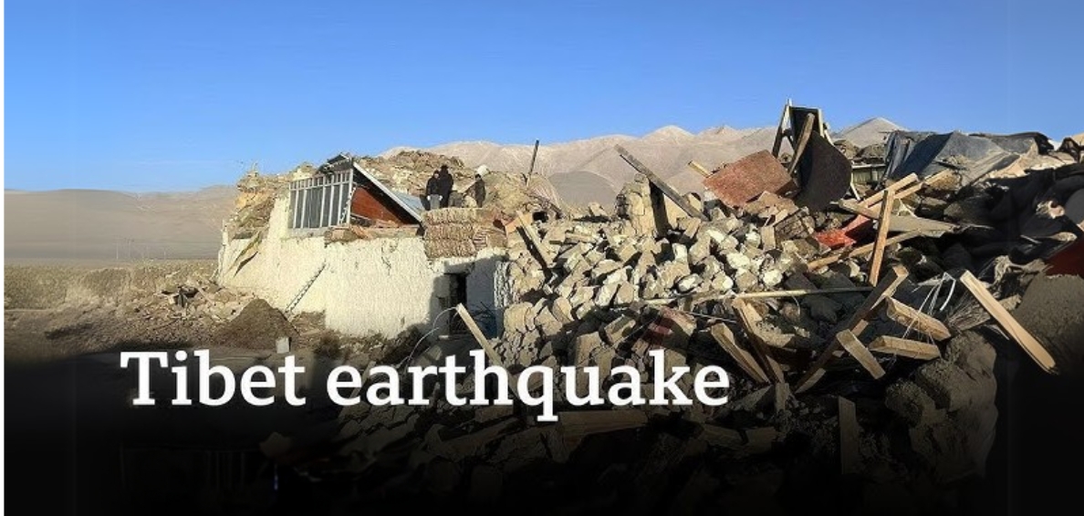
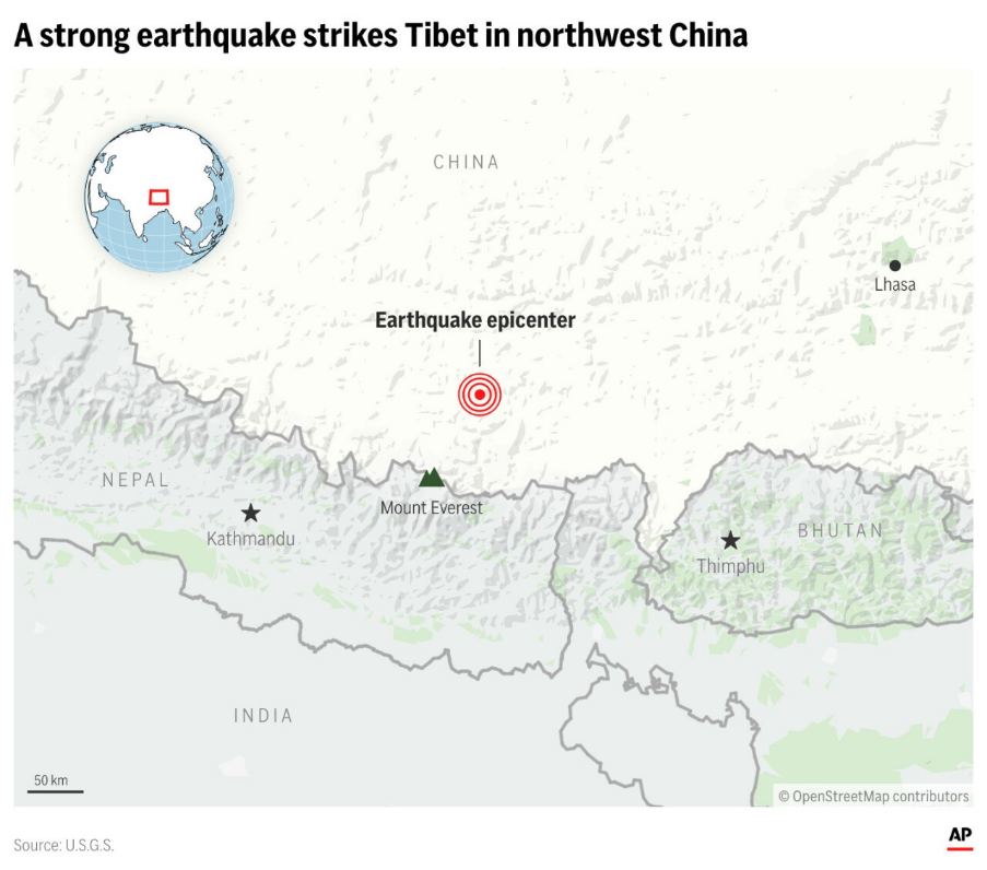
- In January 2025, a powerful earthquake with a magnitude of 7.1 struck the Tibetan region of China and Nepal. The epicenter was located 10 km below the surface, around 80 km north of Mount Everest.
- This natural disaster caused significant loss of life and property, with 95 people reported dead, 130 injured, and hundreds of houses flattened. The tremors were felt as far away as Kathmandu, Thimphu, and Kolkata.
Location and Geographical Context
- Epicenter Details: The earthquake’s epicenter was in Tingry County, Shigatse region, Tibet.
- This region lies at an average elevation of 4-5 km above sea level and is home to approximately 8 lakh people, with Tingry County housing around 7,000 residents.
Regional Significance
- Spiritual Importance: Shigatse is the traditional seat of the Panchen Lama, a prominent figure in Tibetan Buddhism. The region houses the Tashilhunpo Monastery.
- Tourism Gateway: Tingry County serves as a gateway for expeditions to Mount Everest and other Himalayan peaks. However, tourist access to the region was closed following the earthquake.
- Agriculture: The Shigatse region have fertile river valleys and grasslands, alongside semi-tropical jungles and high-altitude snowfields.
Geological Background
- The Lhasa Terrane: The epicenter was likely located in the Lhasa terrane, a geological fragment of crustal material that forms part of southern Tibet. Key features of the Lhasa terrane include:
- Geological History: The Lhasa terrane joined the Eurasian Plate during the Cretaceous period and played a major role in forming the Himalayas.
- Gangdese Batholith: This geological structure, formed 100 million years ago through subduction-related volcanism, illustrates the area’s complex geological past.
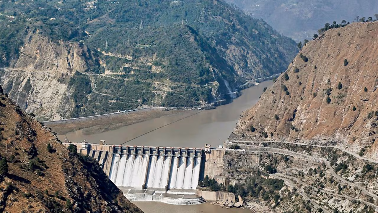
- Hydroelectric Power: The terrane includes sites for China’s massive hydroelectric dam project on the Yarlung Tsangpo River, which has sparked environmental and geopolitical concerns.
- Himalayan Seismic Activity: The Himalayan region is one of the world’s most seismically active zones, classified as Seismic Zone IV and V in India’s seismic zoning map. Contributing factors include:
- Tectonic Collision: The Indian Plate’s ongoing collision with the Eurasian Plate generates immense stress, released through earthquakes.
- Active Fault Lines: Fault systems like the Main Central Thrust and Main Boundary Thrust contribute to seismic activity.
- Young Geology: The Himalayas, being geologically young, are structurally unstable.
Causes of the Earthquake
Earthquakes in this region primarily result from:
- Plate Tectonics: The Indian Plate’s subduction beneath the Eurasian Plate creates tension, periodically released as earthquakes.
- Historical Context: Since 1950, more than 21 earthquakes of magnitude 6 or higher have occurred in the Lhasa terrane. In 2017, a 6.9 magnitude earthquake struck near Mainling, 960 km east of Tingry County.
Consequences
Immediate Impacts
- Landslides and Avalanches: The steep Himalayan terrain increases the likelihood of landslides, causing infrastructure damage and loss of life.
- Glacial Lake Outburst Floods (GLOFs): Earthquakes can destabilize glacial lakes, triggering catastrophic flooding.
Long-term Effects
- Tectonic Changes: Earthquakes may alter river courses and destabilize glaciers and lakes, impacting ecosystems and settlements.
- Cultural Loss: Damage to ancient monasteries, temples, and other cultural sites is a significant concern.
Measuring and Understanding Earthquakes
Earthquake Waves
- Body Waves: Include P waves (primary, fastest) and S waves (secondary, slower and restricted to solid media).
- Surface Waves: Travel along the Earth’s surface and cause most of the observed damage.
Measurement Scales
- Richter Scale: Measures the magnitude of seismic waves and the energy released.
- Mercalli Scale: Assesses the earthquake’s intensity based on observed effects.
Mitigation and Preparedness
- Stricter Building Regulations: Ensure buildings are designed to withstand high-magnitude earthquakes.
- Regional Collaboration: Foster knowledge-sharing and cooperative efforts among Himalayan nations for better preparedness.
- Other Measures
- Develop effective early warning systems.
- Increase public awareness about earthquake safety protocols.
- Conduct research and create detailed risk maps to anticipate future seismic hazards.
Implications of the Earthquake
-
Humanitarian Impact
- Casualties and Displacement: The earthquake resulted in significant fatalities and displacement, highlighting the need for robust disaster preparedness and rehabilitation.
-
Environmental Risks
- Hydrological Disruption: Earthquakes can alter river systems and elevate flood risks.
- Glacial Destabilization: Changes in glaciers may accelerate regional warming effects.
-
Regional Tensions
- India-China Relations: Proximity to the Yarlung Tsangpo-Brahmaputra basin raises concerns about water security and the need for cross-border collaboration.
Conclusion
The 7.1 magnitude earthquake in Tibetan China reveals the intricate connections between geological, environmental, and geopolitical factors in the Himalayan region. Beyond immediate relief efforts, the region requires sustained focus on seismic research, sustainable development, and international cooperation to safeguard its people and resources.

|
Also Read |
|
UPSC Foundation Course |
|
| CSAT Foundation Course | |
Indus Waters Treaty Under Climate and Security Stress

Echoes of Tyranny in Democracies

CJI Vows Transparency in Collegium Appointments
Karol Bagh Metro Pillar No. 112, Above Domino's, 22B, First Floor, New Delhi - 110060
Very Important Instruction For Any Issue, Student Must Produce His/Her Fee Receipt. Without Fee Receipt, It Will Not Be Possible To Track Your Details. If You Have Been Given Any Special Consideration, You Must Keep That In Writing And Produce In Case Of Conflict.
Copyright © 2024-2026 ENSURE IAS. All rights reserved.