- Courses
- GS Full Course 1 Year
- GS Full Course 2 Year
- GS Full Course 3 Year
- GS Full Course Till Selection
- Answer Alpha: Mains 2025 Mentorship
- MEP (Mains Enrichment Programme) Data, Facts
- Essay Target – 150+ Marks
- Online Program
- GS Recorded Course
- Polity
- Geography
- Economy
- Ancient, Medieval and Art & Culture AMAC
- Modern India, Post Independence & World History
- Environment
- Governance
- Science & Technology
- International Relations and Internal Security
- Disaster Management
- Ethics
- NCERT Current Affairs
- Indian Society and Social Issue
- NCERT- Science and Technology
- NCERT - Geography
- NCERT - Ancient History
- NCERT- World History
- NCERT Modern History
- CSAT
- 5 LAYERED ARJUNA Mentorship
- Public Administration Optional
- ABOUT US
- OUR TOPPERS
- TEST SERIES
- FREE STUDY MATERIAL
- VIDEOS
- CONTACT US
Chinese Bridge on Pangong Lake
Chinese Bridge on Pangong Lake
China has completed and operationalized a bridge connecting the north and south banks of Pangong Tso lake in Eastern Ladakh. This bridge allows China's People's Liberation Army (PLA) to significantly reduce the time needed to mobilize its troops and tanks.
What is the Pangong Lake Dispute?
About the Lake:
- Pangong Tso is a long, narrow, deep, endorheic lake situated at over 14,000 feet in Ladakh, within the trans-Himalayan region.
- India and China share the lake, with India controlling about one-third and China controlling two-thirds.
- The eastern end of Pangong Tso lies in Tibet.
- The lake is a tectonic lake formed when India separated from Gondwanaland and collided with Asia, creating the Himalayan Mountain range and occupying the space that was originally the Tethys Ocean.
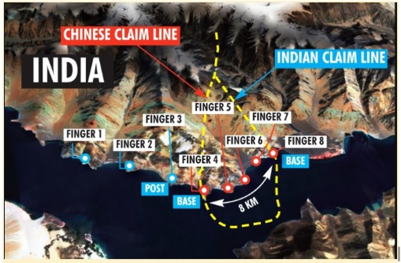
Disputed “Fingers” Area:
-
China has completed and operationalized a bridge connecting the north and south banks of Pangong Tso lake in Eastern Ladakh. This bridge allows China's People's Liberation Army (PLA) to significantly reduce the time needed to mobilize its troops and tanks.
What is the Pangong Lake Dispute?
About the Lake:
- Pangong Tso is a long, narrow, deep, endorheic lake situated at over 14,000 feet in Ladakh, within the trans-Himalayan region.
- India and China share the lake, with India controlling about one-third and China controlling two-thirds.
- The eastern end of Pangong Tso lies in Tibet.
- The lake is a tectonic lake formed when India separated from Gondwanaland and collided with Asia, creating the Himalayan Mountain range and occupying the space that was originally the Tethys Ocean.
Disputed “Fingers” Area:
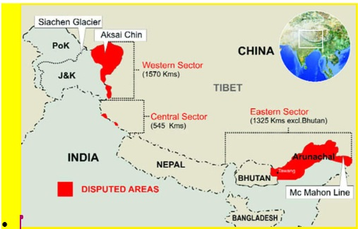
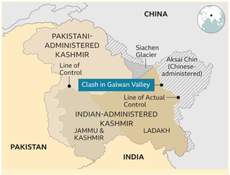
- The India-China border stretches 3,488 kilometers and is not clearly defined in some areas. There is no mutually agreed Line of Actual Control (LAC) in certain stretches. The LAC was established after the 1962 Indo-China war.
- The border is divided into three sectors:
- Western Sector: Ladakh
- Middle Sector: Himachal Pradesh and Uttarakhand
- Eastern Sector: Arunachal Pradesh and Sikkim
- The main areas of dispute are Aksai Chin, located in the western sector, and Arunachal Pradesh, in the eastern sector.
- Aksai Chin: Administered by China as part of Xinjiang, but claimed by India as part of Ladakh.
- Arunachal Pradesh: Claimed entirely by China, calling it "South Tibet," while India considers it an integral part of its territory.
Conclusion: The completion and operationalization of the bridge on Pangong Lake by China have significant strategic implications for the region. The bridge will allow the PLA to mobilize troops and tanks more quickly, raising concerns for India, particularly in areas like Rezang La, where Indian forces have previously outmaneuvered Chinese troops. The India-China border dispute remains complex, with both countries claiming territories and engaging in infrastructure development along the LAC. China's construction of military infrastructure, including roads, underground bunkers, and air combat capabilities, highlights its strategic focus on the region. India has responded by constructing roads, tunnels, and enhancing air power infrastructure to strengthen its military presence along the LAC. The ongoing developments underscore the need for continued vigilance and strategic planning by both countries to manage tensions and maintain peace along the disputed border.
How India Responded with Military Infrastructure Along LAC:
Road Construction: Nearly 6,000 km of roads constructed in border areas in the past five years, with 2,100 km along the northern borders. Examples include the Darbuk-Shyok-Daulat Beg Oldie (DSDBO) road.
Tunnels: All-weather connectivity projects in Ladakh, such as the Zojila and Z-Morh tunnels, and in Arunachal Pradesh, such as the Sela tunnel and Nechiphu bridge, are advancing. Troop Habitat: Rs 1,300 crore spent in the last three years on infrastructure and habitat in Ladakh, including green solutions like Sheela shelters and fuel cells.
Air Power Infrastructure: Increasing availability of heavy lift and logistics helicopters for resupplying materials, such as the deployment of C17 Globemaster and C-130J Super Hercules.
Other Chinese Military Infrastructure Along LAC:
Connectivity: Construction of a road from north of Samzungling to the Galwan Valley. Underground Bunkers: Construction of new underground bunkers, camps, shelters, artillery positions, radar sites, and ammunition dumps along the LAC.
Air Combat: Deployment of additional fighters, bombers, reconnaissance aircraft, and drones to counter high-altitude combat challenges.
Border Villages: Construction of new dual-use ‘Xiaokang’ border villages.
Rear Area Infrastructure: Strengthening of military and transport infrastructure in buffer zones on both banks of Pangong Tso.

Must Check: Best IAS Coaching In Delhi
UPSC Prelims Result 2024 Out: Expected Cut Off & Other Details, UPSC Prelims 2024 Answer with Explanation, Daily Prelims Quiz, Daily Current Affairs, MONTHLY CURRENT AFFAIRS TOTAL (CAT) MAGAZINE, Best IAS Coaching Institute in Karol Bagh, Best IAS Coaching Institute in Delhi, Daily Mains Question Answer Practice, ENSURE IAS UPSC Toppers, UPSC Toppers Markshe

BIS Warns of Global Economic Crossroads Amid Rising Uncertainty
Outdated Forest Data of Forest Survey of India
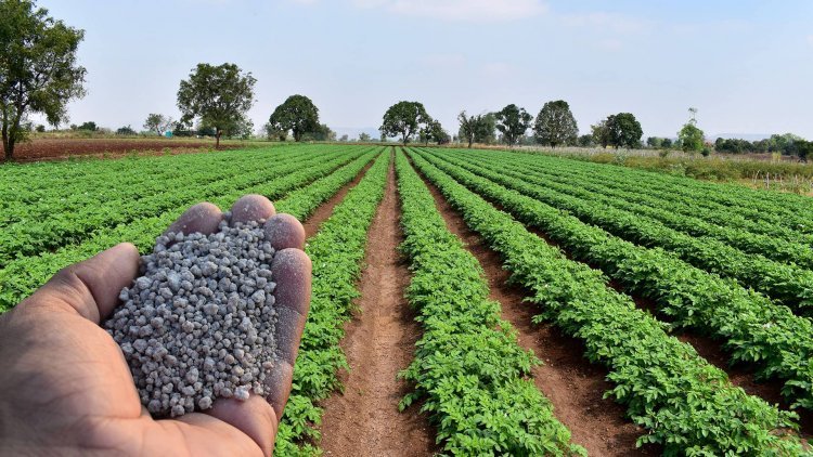
India Faces DAP Crunch Amid China’s Export Restrictions
Karol Bagh Metro Pillar No. 112, Above Domino's, 22B, First Floor, New Delhi - 110060
Very Important Instruction For Any Issue, Student Must Produce His/Her Fee Receipt. Without Fee Receipt, It Will Not Be Possible To Track Your Details. If You Have Been Given Any Special Consideration, You Must Keep That In Writing And Produce In Case Of Conflict.
Copyright © 2024-2026 ENSURE IAS. All rights reserved.