

Context
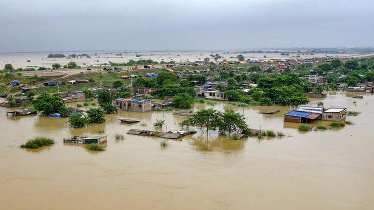
Bihar is facing a severe flood situation in September 2026, with nearly 49.67 lakh people affected across 15 districts as of 15 September. The Ganga crossed the previous highest flood level at Patna’s Gandhi Ghat, while several rivers including the Kosi, Gandak, Sone and Burhi Gandak continue to remain above danger or warning levels.
Why is Bihar Highly Vulnerable to Floods?
Bihar is one of India’s most flood-prone states. The Bihar Government estimates about 68.80 lakh hectares, or nearly 73% of the state’s geographical area, as flood-prone.
Natural causes:
- Himalayan rivers: Rivers such as Kosi, Gandak, Bagmati, Kamla-Balan and Mahananda originate in or pass through the Himalayan region and carry large quantities of water and sediment into the plains.
- High sediment load: Himalayan rivers transport huge quantities of silt, which raises riverbeds and reduces channel capacity.
- Flat topography: The gentle slope of the Gangetic plains slows drainage and allows floodwater to spread over large areas.
- Confluence with Ganga: Many north Bihar rivers ultimately join the Ganga, creating congestion when the Ganga itself is in high flood.
- River-course changes: Rivers such as the Kosi are highly dynamic and can change their course, increasing uncertainty for settlements and infrastructure.
- Backwater effect: A high Ganga can restrict the discharge of tributaries into it, causing water to back up into adjoining areas.
Human-Induced Causes:
- Encroachment of drainage channels and floodplains reduces natural water storage and drainage.
- Poor urban drainage increases waterlogging in towns and cities.
- Unplanned construction in flood-prone areas increases exposure.
- Embankment-induced drainage problems can trap water on the protected side when adequate drainage outlets are absent.
- Deficient maintenance and breach risks can convert local river flooding into a major disaster.
- Wetland degradation reduces natural flood-storage capacity.
Why Floods Remain Difficult to Contain
- Structural Limitations: Embankments require continuous maintenance and strengthening; sedimentation increases pressure, while embankments may worsen waterlogging elsewhere.
- Drainage Problems: Silted channels, blocked drains and wetland loss delay floodwater recession and prolong waterlogging.
- Transboundary River Management: Rivers originating in Nepal require India–Nepal cooperation on rainfall, discharge, reservoirs and flood forecasting.
- Riverbank Erosion: Flood-induced erosion causes loss of farmland, houses, roads and public infrastructure, particularly along the Ganga and north Bihar rivers.
- Climate Variability: Increasingly erratic and intense rainfall causes sudden river-level rises and makes historical flood patterns less reliable.
Impacts of Bihar Floods
Economic Impacts
- Damage to standing crops, livestock and agricultural land.
- Destruction of roads, bridges, embankments, houses and power infrastructure.
- Disruption of markets, transport and supply chains.
- Loss of income for farmers, agricultural labourers and informal workers.
Social Impacts
- Displacement and temporary migration of rural communities.
- Disruption of education and healthcare services.
- Greater vulnerability of women, children, elderly persons and persons with disabilities.
- Increased risk of water-borne diseases due to contamination of drinking-water sources.
Environmental Impacts
- Riverbank erosion and loss of fertile land.
- Damage to wetlands and aquatic ecosystems.
- Contamination of surface-water sources.
- At the same time, controlled seasonal flooding can replenish soil moisture and nutrients, highlighting the need to manage floods rather than simply eliminate natural river processes.
Flood Management in Bihar
A. Structural Measures
- Construction and strengthening of embankments along vulnerable river stretch.
- Bank protection and revetment to control erosion.
- Construction of spurs and guide bunds to regulate river flow and protect embankments.
- Drainage improvement to facilitate the quick removal of stagnant floodwater.
- Strengthening of bridges, roads and critical infrastructure against flood forces.
- Development and maintenance of flood shelters and raised platforms in vulnerable areas.
- Creation of suitable reservoir and storage capacity in upstream catchments, wherever technically, environmentally and socially feasible.
- Restoration of natural drainage channels and wetlands as flood-storage areas.
B. Non-Structural Measures
- Flood Forecasting & Early Warning: Strengthen real-time monitoring, integrate CWC–IMD–satellite data and provide last-mile, location-specific alerts.
- Floodplain Zoning: Map flood-risk zones and regulate construction and land use in high-risk areas.
- Community-Based Disaster Management: Train communities in evacuation, first aid and rescue, and strengthen local disaster-management committees.
- Risk-Informed Infrastructure: Promote flood-resilient infrastructure and housing and ensure critical transport connectivity.
- Risk Financing: Strengthen crop insurance, livelihood protection and timely disaster-relief financing.
Government Initiatives and Institutional Measures
- Bihar State Disaster Management Authority (BSDMA)
-
- Established under the Disaster Management Act, 2005.
- Responsible for disaster-management policy, planning, capacity building and public awareness.
- Bihar has also developed district-level preparedness and response mechanisms.
- Water Resources Department, Bihar
-
- Responsible for embankment construction and maintenance, riverbank protection, flood-control works and drainage.
- It also works on interstate and basin-level water-resource management.
- Flood Management Improvement Support Centre
-
- Established under the Bihar Kosi Basin Development Project.
- Uses data, simulations and flood-flow analysis to improve forecasting and advance warnings.
- Embankment Asset Management System
-
- Bihar has developed Bagmati and Kosi EAMS to monitor embankments and associated infrastructure.
- The system integrates engineering information, river data and flood-forecasting information for improved decision-making.
- Standard Operating Procedures for Flood Management
-
- Bihar has issued SOPs covering pre-flood preparedness, rescue and relief, post-flood action and reconstruction.
- The state has also published an updated SOP for Flood Disaster Management, 2026.
Way Forward
- Shift from Flood Control to Risk Management: Reduce exposure, vulnerability and losses rather than trying to eliminate floods.
- Adopt Basin-Level Planning: Manage rivers at the basin scale through coordination among Bihar, neighbouring states, Nepal and central agencies.
- Strengthen Embankments: Ensure regular maintenance and risk-based strengthening, while integrating embankments with drainage and floodplain management.
- Restore Natural Drainage: Rejuvenate drainage channels and wetlands to reduce prolonged waterlogging.
- Improve Sediment Management: Strengthen sediment monitoring and incorporate river morphology into infrastructure planning.
- Strengthen Early Warnings: Develop village-level, impact-based alerts using real-time river, rainfall, satellite and hydrological data.
- Regulate Floodplains: Prepare flood-hazard maps and restrict settlements and critical infrastructure in high-risk areas.
- Strengthen India–Nepal Cooperation: Enhance real-time data sharing, joint forecasting and basin-level watershed management.
- Build Resilient Livelihoods: Promote flood-resilient agriculture, livelihood diversification, insurance and social protection.
- Adopt Climate-Resilient Governance: Integrate climate projections into risk mapping, infrastructure and disaster planning, shifting from relief to prevention and resilience.
FAQs
- Why is Bihar particularly vulnerable to floods?
Bihar has a flat Gangetic terrain and is crossed by several Himalayan rivers carrying high water and sediment loads. Many river catchments also lie outside Bihar, particularly in Nepal. - Why is the Kosi called the “Sorrow of Bihar”?
The Kosi carries heavy sediment, frequently changes its course and has historically caused extensive flooding and erosion across north Bihar. - What is the major limitation of embankment-based flood management?
Embankments can reduce inundation in protected areas but may increase drainage problems and waterlogging. They also remain vulnerable to erosion, overtopping and structural failure. - Why is India–Nepal cooperation important for Bihar floods?
Major rivers entering north Bihar originate or have significant catchments in Nepal. Upstream rainfall, river discharge and reservoir information are therefore essential for downstream flood forecasting and preparedness. - How can climate change affect Bihar’s flood risk?
Greater rainfall variability, intense short-duration rainfall and changing river-flow patterns can increase the uncertainty, intensity and timing of floods.