

Context
Denmark has inaugurated a Carbon Capture and Storage (CCS) project in the North Sea to store captured carbon dioxide (CO₂) beneath the seabed of a depleted oil field.
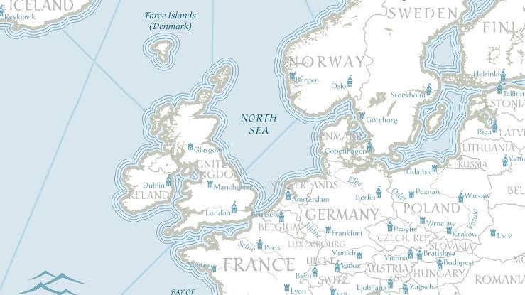
About the North Sea
- Location: A shallow sea of the North Atlantic, located between the British Isles and northwestern Europe.
- Boundaries: Bordered by Great Britain, Norway, Denmark, Germany, the Netherlands, Belgium and France; the Orkney and Shetland Islands lie to its northwest.
- Connections: Linked to the Atlantic Ocean through the English Channel and the Baltic Sea through the Skagerrak and Kattegat.
- Major Rivers: Rhine, Meuse, Scheldt, Thames, Elbe, Weser, Ems, Forth and Humber drain into the North Sea.
Economic Importance
- Energy Resources: The seabed contains substantial oil and natural gas reserves, supporting Europe’s energy supply.
- Fisheries: Its nutrient-rich waters support highly productive fisheries.
- Trade and Transport: A key maritime trade route linking Europe with global markets, including the Middle East.
- Carbon Storage: Its depleted offshore oil and gas formations provide suitable sites for geological CO₂ storage, supporting carbon-management efforts.
FAQs
Q1. Where is the North Sea located?
Ans: It lies in the North Atlantic Ocean, between the British Isles and northwestern Europe.
Q2. Which major rivers drain into the North Sea?
Ans: Important rivers include the Rhine, Meuse, Scheldt, Thames, Elbe, Weser, Ems, Forth and Humber.
Q3. How is the North Sea connected to the Baltic Sea?
Ans: It is connected to the Baltic Sea through the Skagerrak and Kattegat.
Q4. What is Carbon Capture and Storage (CCS)?
Ans: CCS involves capturing CO₂ emissions, transporting them and storing them deep underground to prevent their release into the atmosphere.