
Context
The Uttar Pradesh Government has submitted a report to the National Green Tribunal (NGT) on the demarcation of the Solani River floodplain. The assessment uses a 1-metre Digital Elevation Model (DEM) and a 100-year return period to identify areas vulnerable to flooding.
About Solani River
- Origin: Himalayan foothills near Dehradun, Uttarakhand.
- Course: It flows through parts of Uttar Pradesh, including Saharanpur and Muzaffarnagar districts.
- Confluence: It joins the Banganga River upstream of Shukratal.
- Catchment: The basin receives around 1,170–1,500 mm of annual rainfall and has predominantly loamy soils.
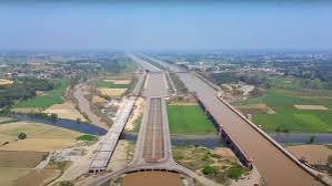
- Solani Aqueduct: Located near Roorkee, it is a historic 19th-century masonry aqueduct that carries the Upper Ganga Canal over the Solani River. It is an important example of early hydraulic engineering in India.
What is Floodplain Demarcation?
- A floodplain is the relatively low-lying area alongside a river that may be inundated during floods.
- Digital Elevation Models (DEMs) provide detailed information about ground elevation and help identify areas likely to be flooded.
- A 100-year return period means a flood having a 1% probability of occurring in any given year. It does not mean such a flood occurs only once every 100 years.
National Green Tribunal (NGT)
- Established in 2010 under the National Green Tribunal Act, 2010.
- It is a specialised judicial body for the effective and speedy disposal of environmental cases.
- It deals with matters relating to environmental protection, forests, natural resources and environmental rights.
- It can provide relief and compensation to victims of environmental damage.
Significance of the Exercise
- Helps identify flood-prone areas scientifically.
- Supports regulated construction and land-use planning.
- Reduces risks to life, property and infrastructure.
- Helps protect the river’s natural floodplain and drainage system.
- Provides a scientific basis for disaster-risk reduction and climate-resilient urban planning.
FAQs
Q1. Where does the Solani River originate?
Ans: It originates in the Himalayan foothills near Dehradun, Uttarakhand.
Q2. Which river does the Solani River join?
Ans: It joins the Banganga River upstream of Shukratal.
Q3. What is the significance of the Solani Aqueduct?
Ans: It is a historic 19th-century masonry aqueduct near Roorkee that carries the Upper Ganga Canal over the Solani River.
Q4. What is a 100-year return period?
Ans: It refers to a flood with a 1% chance of occurring in any particular year, rather than a flood that occurs only once in 100 years.
Q5. Why is floodplain demarcation important?
Ans: It helps identify areas vulnerable to flooding and supports safe land-use planning, construction regulation and disaster-risk reduction.