Context
Scientists from the University of Washington have explained the declining water levels of the Colorado River, pointing to major changes in the hydrological cycle of the American West.
About Colorado River
- The Colorado River is a major river of North America, often called the “Lifeline of the Southwest” due to its importance in arid regions.
- It originates in the Rocky Mountains of Colorado (USA) and flows westward and southward for about 1,450 miles (2,330 km) before emptying into the Gulf of California in Mexico.
- The river passes through seven U.S. states and two Mexican states, draining a vast arid and semi-arid region.
- It forms major reservoirs such as Lake Mead and Lake Powell, which are crucial for water storage and supply.
- A section of the river acts as an international boundary between Arizona (USA) and Mexico, highlighting its geopolitical significance.
- Important tributaries include the Green, Gunnison, San Juan, Dolores, Little Colorado, Gila, and Virgin rivers, contributing to its extensive basin.
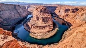
- The river has carved the Grand Canyon over millions of years, a UNESCO World Heritage Site, and also flows through notable landscapes like Canyonlands National Park and Horseshoe Bend, making it a major natural and tourist landmark.