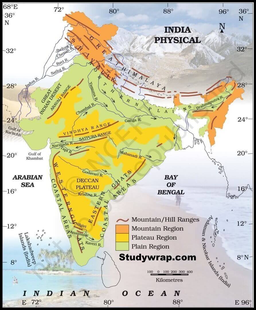
India is a land defined by some of the most magnificent and ancient mountain systems in the world. These Mountain Ranges in India play a pivotal role in shaping the country’s diverse geography, influencing its monsoon-driven climate, and providing the source for its perennial river systems. From the towering, snow-capped Himalayas in the north to the ecological hotspots of the Western Ghats in the south, these ranges are integral to India’s cultural, spiritual, and environmental landscape.
Key Mountain Ranges in India: An Overview
India’s topography is characterized by various mountain systems that cover nearly every region of the country, each contributing unique geological and biological value.
1. The Himalayan Range
The Himalayas are the world’s youngest and most prominent fold mountain ranges, formed millions of years ago by the collision of the Indian and Eurasian plates. They stretch approximately 2,500 km from west to east, acting as a massive natural barrier between the Indian subcontinent and the Tibetan Plateau.
- Length: ~2,500 km.
- Width: 160–400 km.
- Highest Peak: Mount Everest (8,848.86 meters).
- Division: They are divided into three parallel ranges:
- Greater Himalayas (Himadri): The northernmost range with an average elevation of 6,000 meters. It contains peaks like Kanchenjunga and is the source of the Ganga and Yamuna rivers via glaciers like Gangotri.
- Lesser Himalayas (Himachal): Situated south of Himadri with elevations between 3,700 and 4,500 meters. It includes the Pir Panjal and Dhauladhar ranges and famous hill stations like Shimla and Nainital.
- Outer Himalayas (Shivalik): The youngest southernmost range, composed of loose sediments and rising to 1,500–2,000 meters. It features fertile valleys known as Duns (e.g., Dehradun).
2. The Karakoram Range
Located in the northernmost part of India (Ladakh and Jammu & Kashmir), this is one of the world’s highest-altitude systems.
- Highest Peak: K2 (8,611 meters), the second-highest mountain on Earth.
- Glaciers: Home to the Siachen Glacier, the longest glacier outside the polar regions.
- Significance: Holds immense strategic and defense importance for India.
3. The Aravalli Range
The Aravallis are among the oldest mountain ranges in the world, now categorized as residual mountains due to millions of years of erosion.
- Extent: Stretches 700 km across Delhi, Haryana, Rajasthan, and Gujarat.
- Highest Peak: Guru Shikhar (1,722 m) in Mount Abu, Rajasthan.
- Significance: Acts as a natural barrier preventing the eastward expansion of the Thar Desert.
4. The Western Ghats (Sahyadri Hills)
Running parallel to the western coast for 1,600 km, this range is a UNESCO World Heritage Site and a global biodiversity hotspot.
- Extent: Gujarat, Maharashtra, Goa, Karnataka, Kerala, and Tamil Nadu.
- Highest Peak: Anamudi (2,695 m) in Kerala, which is the highest point in South India.
- Significance: Crucial for regulating the Indian monsoon and maintaining ecological balance.
5. The Eastern Ghats
A discontinuous, eroded range running along the eastern coast that is lower in elevation than the Western Ghats.
- Highest Peak: Jindhagada Peak (Arma Konda/Sitamma Konda) at 1,690 m in Andhra Pradesh.
- Features: Intersected by major east-flowing rivers such as the Godavari, Krishna, and Kaveri.
Mountain Ranges of Central and North East India
The Vindhya and Satpura Ranges
These central Indian ranges define the boundary between Northern and Southern India.
- Vindhya Range: A discontinuous chain extending across MP, UP, Bihar, and Chhattisgarh. Its highest point is Sad-Bhawna Shikhar (752 m).
- Satpura Range: Lies south of the Vindhyas, separating the Narmada and Tapi river valleys. Its highest peak is Dhupgarh (1,350 m) near Pachmarhi.
The Purvanchal and North East Hills
Located in northeastern India, these hills curve southward beyond the Dihang River.
- Major Hills: Includes the Patkai, Naga, Mizo, Garo, Khasi, and Jaintia
- Highest Peak: Dapha Bum (4,570 m).
- Significance: Forms a natural boundary with Myanmar and China and is rich in tribal culture and biodiversity.
State-Wise and Regional List of Mountain Ranges
Table: Mountain Ranges in North India (North to South)
| Mountain Range | Primary Location/State |
| Saltoro Mountains | Ladakh |
| Karakoram Range | Ladakh |
| Ladakh Range | Jammu & Kashmir |
| Zanskar Range | Jammu & Kashmir |
| Pir Panjal Range | Jammu & Kashmir |
| Dhauladhar Range | Himachal Pradesh |
| Shivalik/Dundwa Range | Northern Uttar Pradesh |
Table: Western Ghats and South Indian Mountains
| Mountain Range | States |
| Satmala and Ajanta Hills | Maharashtra |
| Harishchandra and Balaghat Range | Maharashtra |
| Kudremukh and Baba Budan Hills | Karnataka |
| Nilgiri Hills | Junction of Tamil Nadu, Kerala, and Karnataka. Highest Peak: Doddabetta (2,637 m). |
| Anaimalai and Cardamom Hills | Tamil Nadu and Kerala |
| Palani Hills | Tamil Nadu and Kerala |
Comprehensive List of North East Mountain Peaks
| Mountain Range | Location (State) | Highest Peak | Approx. Height |
| Patkai and Naga Hills | Arunachal Pradesh, Nagaland | Mount Saramati | 3,841 m |
| Khasi Hills | Meghalaya | Lum Shyllong | 1,965 m |
| Garo Hills | Meghalaya | Nokrek Peak | 1,412 m |
| Mizo Hills (Lushai) | Mizoram | Blue Mountain (Phawngpui) | 2,157 m |
Frequently Asked Questions (FAQs)
WHICH IS THE HIGHEST PEAK IN THE WESTERN GHATS?
Anamudi, located in Kerala, is the highest peak in the Western Ghats with an elevation of 2,695 meters.
WHERE IS THE GURU SHIKHAR PEAK LOCATED?
Guru Shikhar is the highest peak of the Aravalli Range, situated in Mount Abu, Rajasthan.
WHAT ARE THE THREE PARALLEL RANGES OF THE HIMALAYAS?
The Himalayas consist of the Greater Himalayas (Himadri), the Lesser Himalayas (Himachal), and the Outer Himalayas (Shivalik).
WHICH MOUNTAIN RANGE ACTS AS THE BOUNDARY BETWEEN NORTH AND SOUTH INDIA?
The Vindhya Range in Central India forms a natural boundary between North and South India.
WHICH RANGE IS HOME TO THE WORLD’S SECOND-HIGHEST PEAK, K2?
The Karakoram Range, located in the northern regions of Ladakh and Jammu & Kashmir, contains K2.
WHAT IS THE SIGNIFICANCE OF THE NILGIRI HILLS?
The Nilgiri Hills serve as the vital meeting point of the Western and Eastern Ghats in Southern India.
WHICH MOUNTAIN RANGE IS KNOWN AS THE “BLUE MOUNTAINS”?
The Nilgiri Hills are commonly referred to as the “Blue Mountains”.
WHICH IS THE HIGHEST POINT IN THE SATPURA RANGE?
Dhupgarh, with a height of 1,350 meters, is the highest peak in the Satpura Range.
NAME THE MAJOR EAST-FLOWING RIVERS THAT CUT THROUGH THE EASTERN GHATS.
The Eastern Ghats are intersected by the Mahanadi, Godavari, Krishna, and Kaveri rivers.
WHAT ARE “DUNS” AND WHERE ARE THEY FOUND?
Duns are fertile longitudinal valleys, such as Dehradun, located in the Outer Himalayas (Shivalik Hills).