Sierra Leone
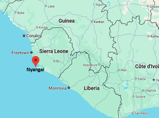
Why in the News?
- Nyangai, part of the Turtle Islands in southern Sierra Leone, is facing severe land erosion due to rising Atlantic sea levels and climate change.
- The island has lost two-thirds of its surface area, now measuring just 200 m long and 100 m wide.
- The crisis is impacting the livelihood and survival of its residents, especially fishermen.
- The situation highlights the vulnerability of low-lying coastal communities despite their minimal contribution to global warming.
- It serves as a powerful example of climate injustice, where the least polluting communities suffer the most from the consequences of climate change.
About Sierra Leone
- Location: Sierra Leone is a tropical country in West Africa, situated along the Atlantic Ocean.
- Borders: It shares borders with Guinea to the north and east, Liberia to the south, and the Atlantic Ocean to the west.
- Geography: The country features lightly wooded hills inland and mangrove swamps along its coastline.
- Major Rivers: Key rivers include the Rokel, Taia, Moa, and Sewa rivers.
- Political System
- Sierra Leone is a constitutional republic with a directly elected President and a unicameral legislature.
- Capital: Freetown, which has one of the world’s largest natural harbours.
- Economy
- While most people engage in subsistence farming, Sierra Leone is also known for its mineral wealth.
- Key resources include diamonds, gold, bauxite, and rutile (used to produce titanium dioxide).
Red Sea
Why in the News?
- Yemen’s Houthi rebels attacked a Liberian-flagged cargo ship in the Red Sea, resulting in the death of three mariners and injuries to two others.
- This is part of a series of Houthi-led attacks on commercial shipping in the region since November 2024, threatening a vital global maritime trade route.
- The ship came under attack while moving toward the Suez Canal, highlighting the escalating risks to international shipping and the region’s strategic importance.
- The European Union naval force confirmed the attack and casualty details, marking increased international concern over maritime security in the Red Sea.
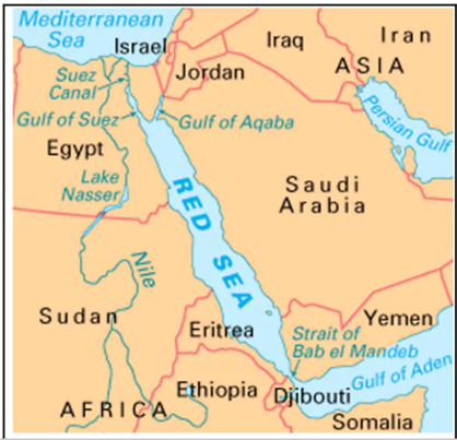
About Red Sea
- The Red Sea is a narrow inlet of the Indian Ocean located between the continents of Africa and Asia.
- An inlet is a narrow strip of water extending from a sea or lake into the land or between islands.
- It is one of the world’s northernmost tropical seas and also among the busiest maritime trade routes globally.
- It connects to the Indian Ocean in the south through the Bab el-Mandeb Strait and the Gulf of Aden.
- In the north, the Red Sea is divided by the Sinai Peninsula into two arms:
- The Gulf of Aqaba
- The Gulf of Suez, which further connects to the Mediterranean Sea via the Suez Canal.
- The Red Sea is part of the Great Rift Valley, specifically the Afro-Arabian Rift System, which is geologically active.
- Bordering Countries:
- East: Saudi Arabia and Yemen
- North: Egypt
- West: Sudan, Eritrea, Djibouti
- Other Characteristics
- It stretches approximately 2,250 km and has a surface area of around 438,000 sq. km.
- Its name likely comes from occasional reddish-brown algae blooms (Trichodesmium erythraeum) that change the water’s colour.
- Notable Islands include Tiran Island (near the Gulf of Aqaba) and Shadwan Island (near the Gulf of Suez).