Why in the News?
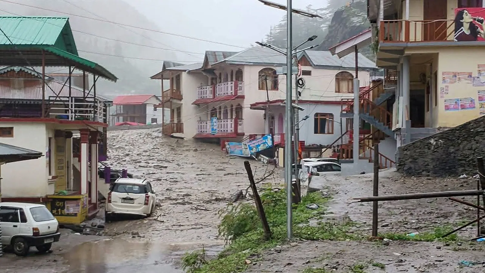
- In August 2025, flash floods and mudslides struck Dharali village in Uttarkashi district, Uttarakhand, leading to the death of at least four people and over 60 reported missing.
- The floods were triggered by continuous heavy rainfall over the past few days, even though no official cloudburst
- The event took place in the Bhagirathi Eco-Sensitive Zone (BESZ), raising serious concerns about unregulated construction, climate change, and inadequate disaster preparedness in the Himalayan region.
Key Highlights
- Sequence of the Disaster
- In August 2025, Dharali village, located just 10 km from the tourist spot Harsil, was hit by flash floods and a debris avalanche.
- Continuous rainfall over 3 days saturated the soil in this fragile Himalayan slope, triggering mudslides and the flow of loose moraine and debris into rivers.
- The forceful flow of debris and water devastated buildings, shops, and hotels, and washed away roads.
- Initial suspicion of a cloudburst was ruled out by the India Meteorological Department (IMD), whose data showed only 7 mm rainfall in 24 hours, well below the 100 mm/hour threshold required for a cloudburst classification.
- Experts suspect a Glacial Lake Outburst Flood (GLOF) or localised debris/mudslide may be responsible.
- Topography and Vulnerability of Uttarkashi
- Uttarkashi district lies at altitudes between 800 and 6,900 metres above mean sea level, making it extremely vulnerable to landslides and flash floods.
- The district includes the source regions of the Ganga (Gangotri) and Yamuna (Yamunotri)
- It is characterized by high mountain ridges, steep valleys, narrow gorges, and fragile slopes.
- The land slopes steeply towards the southwest, leading to rapid accumulation of momentum in debris and water flow.
- Average annual rainfall is 1,289 mm, with July being the wettest month (~312 mm average rainfall).
- The south-facing Himalayan slopes receive heavy monsoon rain and are prone to frequent thunderstorms.
- Rescue Operations and Ground Response
- Immediate response was launched by:
- Indian Army
- National Disaster Response Force (NDRF)
- Immediate response was launched by:
- State Disaster Response Force (SDRF)
- Fire Department
- Local police
- More than 250 personnel were initially deployed, later supported by 200 more from Border Roads Organisation (BRO) and Indo-Tibetan Border Police (ITBP).
- Air Force helicopters were coordinated for:
- Air-dropping essential supplies and medicines
- Evacuation of stranded villagers
- Communication was disrupted due to power outage; satellite phones were sent to restore contact.
- Temporary shelters were opened at various places to support the people.
- Legal and Environmental Concerns
- Dharali lies within the Bhagirathi Eco-Sensitive Zone (BESZ), a 4,157 sq. km zone notified in 2012 to protect the Ganga river’s ecological origin.
- Despite legal protection, unregulated activities were reported:
- Construction of multi-storey hotels
- Helipad development at Jhala
- Proposed Char Dham bypass road between Hina and Tekhla, which threatened 6,000 Deodar trees
- The Char Dham All-Weather Road Project, particularly the Dharasu–Gangotri stretch, has faced objections due to:
- Absence of proper Environmental Impact Assessment (EIA)
- Road-widening in unstable geological zones
- Ignoring warnings from Supreme Court-appointed committees
- Climate Change and Increased Risk
- Scientists and disaster experts link the increasing frequency of such events to climate change, which causes:
- Rising atmospheric moisture (7% per °C of warming)
- Accelerated glacial melting
- Scientists and disaster experts link the increasing frequency of such events to climate change, which causes:
- Unpredictable and erratic monsoon patterns
- Flash floods, cloudbursts, and landslides are becoming more intense and frequent across the Hindu Kush Himalayan Region.
- Traditional disaster infrastructure (like embankments and dams) is inadequate to deal with such extreme events.
Past Flash Floods and Cloudbursts in Uttarakhand
| Date | Location | Impact |
| August 2022 | Dehradun–Tehri–Pauri | Cloudburst, bridges washed away, sacred sites flooded |
| September 2022 | Dharchula, Pithoragarh | Cloudburst near Kali river, 1 death |
| August 2024 | Ghansali, Tehri Garhwal and Kedarnath Valley | Cloudburst, severe landslides, pilgrim movement halted, damage to Kedarnath path |
| June 29, 2025 | Yamunotri Highway, Uttarkashi | Cloudburst killed 2, 7 missing, Chardham Yatra suspended |
Why Are These Incidents Rising Across India?
The increasing frequency and severity of flash floods, cloudbursts, and landslides across India, particularly in Himalayan and hilly regions, is a result of multiple interlinked natural and human-induced factors:
- Climate Change and Warming Atmosphere
- Global warming is increasing the temperature of the troposphere, leading to more moisture retention in the air.
- Warmer air holds 7% more water vapour per 1°C rise, intensifying rainfall events.
- This leads to short, sudden, and extremely heavy rainfall events — the ideal trigger for flash floods and cloudbursts.
- Erratic Monsoon Patterns
- The Indian monsoon is becoming increasingly unpredictable: delayed onset, concentrated rainfall, early withdrawal.
- Instead of moderate rain over a season, rainfall now occurs in short, high-intensity bursts, overwhelming natural drainage.
- Urbanisation and Loss of Natural Buffers
- Rapid urban growth has led to:
- Loss of wetlands, lakes, floodplains, and forests.
- Increase in concrete surfaces, reducing natural infiltration of water.
- Cities like Mumbai, Bengaluru, and Delhi face urban flooding during monsoons due to clogged or inadequate drainage.
- Rapid urban growth has led to:
- Development in Fragile Ecosystems
- Infrastructure projects like dams, roads, tunnels, and hotels in ecologically sensitive areas (e.g., Uttarakhand, Himachal Pradesh, Sikkim) destabilize slopes.
- Hill cutting, deforestation, and blasting alter natural drainage, increasing landslide and flood risks.
- Projects like Char Dham Highway and Hydroelectric Plants have been repeatedly flagged by environmentalists.
- Glacial Retreat and Glacial Lakes
- Accelerated melting of Himalayan glaciers is leading to formation of unstable glacial lakes.
- These can burst (Glacial Lake Outburst Floods or GLOFs), releasing massive volumes of water downstream — as seen in Chamoli (2021) and possibly Uttarkashi (2025).
- Weak Early Warning Systems
- India has limited Automatic Weather Stations (AWS) in high-altitude regions.
- Real-time monitoring and data-based forecasting are still in development phases.
- In many remote areas, early warning does not reach communities in time.
- Poor Land Use Planning and Violations
- Construction continues even in landslide-prone zones, river floodplains, and eco-sensitive areas.
- Environmental Impact Assessments (EIA) are often bypassed or diluted.
- Illegal constructions, even in notified zones like Bhagirathi ESZ, compromise long-term safety.
- Inadequate Community Preparedness
- Locals are often not trained or included in disaster preparedness plans.
- Lack of community-based disaster management leads to higher casualties during sudden disasters.
- Institutional Gaps
- Fragmented coordination between central and state disaster management authorities.
- Policies are often reactive, with insufficient focus on risk mitigation and climate adaptation.
These factors, especially when combined, are making India more vulnerable to climate-induced disasters, with the Himalayan region being the most at risk due to its geological fragility, changing climate, and growing developmental pressure.
Implications
- Humanitarian Consequences
- Loss of lives and injuries to residents and tourists.
- Dozens missing, widespread psychological trauma.
- Displacement of families living near riverbanks.
- Disruption of basic services like electricity, healthcare, and communication.
- Environmental Impact
- Destruction of natural floodplains, forests, and wetlands.
- Flow of debris and construction material into rivers, disturbing aquatic ecosystems.
- Increased soil erosion, deforestation, and biodiversity loss.
- Infrastructure and Economic Loss
- Damage to roads, buildings, and essential services.
- Hindrance to tourism and religious pilgrimage (e.g., Char Dham Yatra).
- Economic setback for local businesses and transport.
- Governance and Policy Failure
- Failure to implement BESZ regulations.
- Construction permitted in landslide-prone and flood-prone zones.
- Weak monitoring and compliance by local authorities.
- Poor early warning dissemination due to limited Automatic Weather Stations (AWS).
- Climate Change Amplification
- Increased frequency of intense weather events like GLOFs and flash floods.
- Vulnerability of Himalayan states like Uttarakhand is increasing due to warming, deforestation, and glacier retreat.
- Requires national and regional climate adaptation frameworks.
Challenges and Way Forward
| Challenges | Way Forward |
| Fragile Himalayan geology and terrain | Conduct hazard zonation mapping; avoid construction in high-risk zones |
| Weak implementation of BESZ laws | Strict enforcement of BESZ rules; penalize illegal construction |
| Outdated infrastructure design | Use resilient designs such as half-tunnels, slope stabilization structures |
| Lack of real-time data | Install more Automatic Weather Stations (AWS) in remote high-altitude zones |
| Inadequate early warning and evacuation | Deploy community-based early warning systems integrated with local knowledge |
| Climate change ignored in planning | Mainstream climate adaptation in urban/rural planning and infrastructure |
| Deforestation and land use change | Promote reforestation, afforestation, and nature-based solutions |
Key Terminologies
- Flash Flood
- A sudden flood of water typically caused by intense rainfall or dam failure in mountainous or arid regions.
- Occurs within 6 hours of the triggering event.
- High velocity, highly destructive.
- Cloudburst
- Defined by India Meteorological Department (IMD) as ≥100 mm rainfall in 1 hour over ~10 km².
- Common in the Himalayan foothills during monsoons.
- Can trigger flash floods and landslides.
- Glacial Lake Outburst Flood (GLOF)
- Sudden release of water from glacial lakes, formed by melting glaciers.
- Causes massive downstream flooding, seen in Chamoli (2021) and possibly Dharali (2025).
- Bhagirathi Eco-Sensitive Zone (BESZ)
- Declared in 2012 under the Environment (Protection) Act, 1986.
- Covers 4,157 sq. km from Gangotri to Uttarkashi.
- Limits construction, prohibits polluting industries, mandates EIAs for large projects.
- Automatic Weather Station (AWS)
- An automated station that records real-time meteorological data (rainfall, temperature, pressure).
- Vital for early warning systems in remote and disaster-prone regions.
- Char Dham All-Weather Road Project
- Flagship road connectivity project to improve access to Yamunotri, Gangotri, Kedarnath, and Badrinath.
- Criticized for ignoring ecological warnings, cutting trees, and triggering landslides.
Conclusion
The flash flood in Uttarkashi’s Dharali village is a stark warning of what happens when fragile ecosystems are subjected to unscientific development and climate inaction. While natural events like rainfall cannot be prevented, their disastrous consequences can certainly be minimized through better planning, strict environmental regulation, and disaster-resilient infrastructure. India must treat the Himalayas as an ecological hotspot, not merely a corridor for tourism and roads.
| Ensure IAS Mains Question
Q. The recent flash floods in Uttarkashi district of Uttarakhand highlight the intersection of fragile Himalayan ecology, climate change, and unregulated development. Discuss the causes and implications of such disasters and suggest a sustainable framework for mitigation and preparedness. (250 words) |
| Ensure IAS Prelims Question
Q. With reference to the recent flash floods in Uttarkashi district, consider the following statements: 1. The India Meteorological Department (IMD) confirmed the event as a cloudburst based on recorded rainfall data. 2. Dharali village is located within the notified Bhagirathi Eco-Sensitive Zone (ESZ). Which of the statements given above is/are correct? a) 1 only b) 2 only c) Both 1 and 2 d) Neither 1 nor 2 Answer: b) 2 only Explanation: Statement 1 is incorrect: The IMD specifically stated that rainfall in Uttarkashi did not meet the criteria for a cloudburst (which is ≥100 mm/hour in a 10 km² area). Rainfall recorded was well below that. Statement 2 is correct: Dharali village lies within the Bhagirathi Eco-Sensitive Zone (ESZ), a protected ecological stretch notified in 2012 to conserve the upper Ganga basin. |