- In December 2024, the Union Ministry of Home Affairs announced that India’s coastline length increased from 7,516.6 km to 11,098.8 km.
- The National Hydrographic Office (NHO), together with the Survey of India (SoI), checked the coastline again.
- This shows a 47.6% increase compared to the old measurement from the 1970s.
- This change was not because India gained new land or islands.
- It happened because of better ways to measure the coastline.
Why Did the Coastline Length Change?
- The old measurement used maps that were not very detailed and had a scale of 1:4,500,000.
- This missed many small features like estuaries, creeks, and sandbars.
- Islands like Andaman & Nicobar and Lakshadweep were not fully counted before.
- The new measurement used more detailed maps at a scale of 1:250,000.
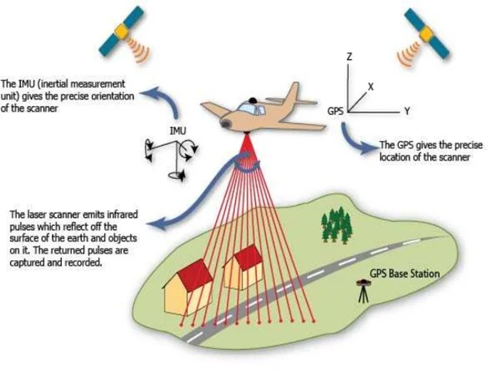
- Modern technology like GIS, satellite data, LIDAR-GPS, and drones helped in measuring.
- The measurement was done using the high tide line as a base.
- River mouths and creeks were measured by drawing boundaries inland to keep things consistent.
- Islands that appear at low tide were also included.
- This gave a longer coastline length.
- The government will update coastline length every 10 years from 2024-25 onwards.
How GIS, Satellite Data, LIDAR-GPS, and Drones Helped Measure the Coastline
- GIS (Geographic Information Systems) helps collect, store, and analyze geographic data on maps.
- It allows combining many types of data like satellite images, surveys, and maps into one system.
- This helps map the coastline in much greater detail than before.
- Satellite data provides high-resolution images of large coastal areas from space.
- Satellites can capture details about the shoreline, landforms, and changes over time.
- This helps measure the coastline more precisely and monitor erosion or land changes regularly.
- LIDAR-GPS uses laser light from aircraft or drones to measure distances very accurately.
- It creates detailed 3D maps of the land and coastline by scanning its shape and height.
- GPS helps pinpoint exact locations, making measurements very precise.
- This method can capture small features like sandbars, tidal flats, and creeks that older maps missed.
- Drones can fly close to the coastline and take detailed photos and videos from many angles.
- They can cover areas that are hard to reach or too small for satellites to see clearly.
- Drones provide up-to-date images that help update coastline maps quickly.
- Together, these technologies provide a clearer, more accurate, and detailed picture of India’s coastline.
- This is why the new coastline length is much longer than earlier estimates.
The Coastline Paradox Explained
- The coastline paradox means the length of a coastline depends on how closely you measure it.
- Coastlines have many small bends and details that become clear when you measure carefully.
- Using a large ruler smooths out many details and shows a shorter length.
- Using a small ruler shows more details and makes the coastline seem longer.
- Lewis Fry Richardson first noticed this in the 1950s.
- Benoît Mandelbrot explained it in 1967 using math.
- He showed how the measured length of Britain’s coast changed with the ruler size.
- If you measure with very tiny units, the length could become almost infinite.
- So, the longer coastline of India is because of better and more detailed measurements, not actual land changes.
Geographical Coverage of India’s Coastline
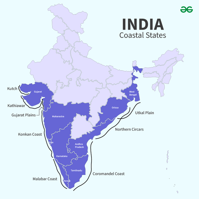
- India’s coastline touches the Bay of Bengal in the east, the Arabian Sea in the west, and the Indian Ocean in the south.
- There are 11 coastal states including Gujarat, Maharashtra, Goa, Karnataka, Kerala, Tamil Nadu, Andhra Pradesh, Odisha, and West Bengal.
- Coastal Union Territories include Daman & Diu, Lakshadweep, Puducherry, and Andaman & Nicobar Islands.
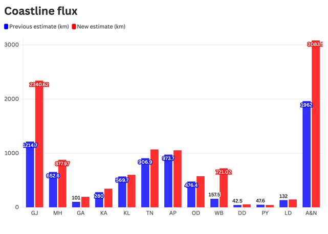
- Some states showed big increases in coastline length:
- Gujarat’s coastline grew from 1,214 km to 2,340 km, still the longest.
- West Bengal’s coastline grew from 157 km to 721 km, the largest percentage increase (357%).
- Tamil Nadu’s coastline grew from 906 km to 1,068 km, overtaking Andhra Pradesh.
- Some states had little or no increase:
- Kerala’s coastline increased by only 30 km (5%).
- Puducherry’s coastline reduced by 4.9 km (-10.4%) because of erosion and better measuring.
Old vs New Measurement Methods
| Aspect | Old Method (1970s) | New Method (2023-24) |
| Measurement basis | Straight lines | Includes all coastal features |
| Coastal features counted | Basic shoreline | Estuaries, creeks, sandbars, inlets |
| Map scale | 1:4,500,000 | 1:250,000 |
| Technology | Manual mapping | GIS, satellite, LIDAR-GPS, drones |
| Accuracy | Less accurate | More accurate and detailed |
| Coastline length | 7,516.6 km | 11,098.8 km |
Types of Coastlines: Emergence and Submergence
- Coastlines of emergence happen when land rises or sea level falls.
- Features include beaches, lagoons, salt marshes, cliffs, and sea arches.
- Examples are the Tamil Nadu coast (Coromandel Coast) and Kerala coast (Malabar Coast).
- Coastlines of submergence happen when land sinks or sea level rises.
- India’s west coast shows both types:
- Northern parts are submerged due to faulting.
- Kerala coast is mostly an emerging shoreline.
Economic and Development Effects
- The longer coastline helps in developing ports and shipping facilities.
- Andhra Pradesh is building more ports like Ramayapatnam, Krishnapatnam, and Kakinada.
- A longer coastline means more fishing areas, better tourism, and more trade.
- Accurate coastline data helps plan security and disaster management.
- It is important for coastal protection and disaster warnings like cyclones and tsunamis.
- It also helps monitor environmental changes like erosion and the health of coastal plants and animals.